Sunday, August 28, 2011

August Hikes 2011

Saturday, August 20: Lees Peak
Rick's hiking companions
The "chute" to the top of Lees
     Rick took off this morning to climb Lees Peak in the Anthony basin.  It was a beautiful day on the mountain, and while his wife and son didn't accompany him, a herd of mountain goats led him for much of the way to the summit of the peak!  He got some great pictures of his escorts.  
Lakes Basin from top of Lees


Friday, August 26:  Copper Creek Falls
See pictures from these hikes HERE
     Rick worked hard during the three days of teacher inservice this week so we could take off on Friday for a hike together.  Since we hadn't been up to Boulder Park all summer and Rick wanted to do a little fishing anyway, I suggested the 5.5 mile round trip hike to Copper Creek Falls and then fishing at Two Color Campground on Eagle Creek.  Whatever we did - we had to get out of the valley and the forecasted 95-98 degrees!  It was warm enough up in the mountains!
Rick and Ging in front of Copper Creek Falls
     It is always amazing when we get up to Boulder Park to remember our first visit to the area shortly after we were married.  Rick bought me a cup of coffee at the Boulder Park lodge!  There were cabins all over the place.  And then the big landslide came, the river flooded, and the lease for the lodge ran out.  Now you can barely see the clearings where the buildings once stood.  But the scar on the hillside from the landslide is still VERY evident!   
     It is late in the year to make this wonderful wildflower hike, but we still are treated to a few hardy survivors of the summer: paintbrush, purple asters, cow parsnip, a few monkeyflowers along creeks, mariposa lilies by Copper Creek Falls, mountain bluebells, larkspur, pussytoes, yarrow, and fields of what I think is horsemint.  We also pass evidence of several fierce avalanches in recent winters: debris, broken trees, etc.  
Meadow areas as you approach Copper Cr Falls
     The trail is busy!  We pass several groups heading OUT from time spent up at Eagle Lake or Lookingglass, etc.  And we pass hikers and backpackers heading IN for the weekend.  It is fun to see families out hiking!  
    Once at Copper Creek and the lower falls, we decide to hike UP the cliffs as I have never been to the top (and you can't see it from the bottom!)  It is a good little climb, but worth it.  We finally arrive at a narrow little draw with deep pools and small cascades - the lull before the water pours over the edge with a flurry!  A good amount of water in the face helps cool us down!  
Rick cools off fishing in Eagle Creek
    On our way back down from the top, we stop to take a picture.  We opted NOT to bring the big gorilla pod tripod, so it takes a bit of a balancing act on the rocks to get the camera set for a timed picture of both of us!  But it was good we stopped, because as we are getting ready to head on down, I discover huckleberries right under our noses!  Big ones!  I feel like a greedy black bear as I strip the branches clean and rapidly stuff them into my mouth! We left a FEW for others, but thoroughly enjoyed 5-10 minutes of feeding!  The berries were the biggest I have ever seen on the east side of the state. 
Ginger enjoying the creek. 
     We hike back on down the trail, the hot summer sun and thoughts of Eagle Creek's cool waters spurring us on!  Once back down at Two Color, Rick heads up stream to fish while I take a book and find a rock in the middle of the creek where I can soak my feet and feel COOL!  Rick is more productive in catching four fish that will feed us for two meals, but I do read a chapter of a book for our fall Bible study!  
     Another great opportunity to enjoy God's creation together and wind up our summer!  


Friday, August 19, 2011

COLORADO VACATION 2011 Part 8 - Silver City, Tucson, and home!

Monday, August 15:
Click HERE to view the remaining trip pictures
            We are up at 6:45 once again, say goodbye to Patty before she leaves for school, pack up the trailer, say our goodbyes to Regan and Rachael, and by 8:20 we are on the road south. 
            From Edgewood to Socorro I pull back out the needlepoint and ALMOST finish a donkey before we arrive in Jed’s town.  We gas up and switch drivers.  I take a 75 mile stretch from Socorro down to south of Truth or Consequences and the turnoff on 152 to Silver City.
Santa Rita Cooper Mine
            Highwayt 152 proves to be a huge surprise.  The first part is typical high desert, shifting from the green of the Rio Grande valley to the high chaparral of the mountains.  About 20 miles in, we begin the climb to what is a MERE 8200’ pass over the Black Mts.  This pass seems like the LONGEST and windiest one of all the passes we have gone over. The road is windy and twisty and steep in places….and interminably long before we reach the summit.  Once over the top the vegetation seems to change to more pine and green and lush.  We drop down to the Mimbres valley, and then back up again toward Santa Rita (a ghost town of the old copper mining days) and eventually to our KOA 4 miles east of Silver City.  We do stop briefly at the Santa Rita Copper Mine site – now a huge open pit mine in action operation 24/7. 
            Our Silver City KOA is a model of how a campground should be run.  I am greeted as I walk into the office with, “Are you Ginger?”  She had seen the tent trailer pull in with the Oregon plates and knew she only had one tent trailer coming in with a reservation today!  Wow!  A very personable gal who shared her obvious love and joy of life in Silver City with us.  Gave us good recommendations.  Everything was ready to go, and we pulled into our site and set up the trailer.  The campground is beautifully groomed and cared for.  We are given a fresh baked cookie as a welcome gift.  Ice cream is served by the pool evenings.  So friendly I just might have to write the KOA people and let them know what a great job this couple does here in Silver City!
Our campsite in Silver City
            We are running a little late (thank you Emory Pass!), so instead of going out to eat we grab a bite from the truck while considering our options for the day.  The road north into Gila Hot Springs and the cliff dwellings is very slow – perhaps even more twisty and winding than Emory Pass.  We have seen cliff dwellings and probably won’t go into the hot springs anyway.  The weather is supposed to be negligible for views – a thunderstorm is forecast and locally heavy rain at times.  In reading through the information, we discover the Catwalk isn’t as far as thought and in fact the driving time is LESS than if we went up to Gila Hot Springs even though the milege is further.  With Krystal Irby’s wise advice about how cool the Catwalk is, we decide to head up 180 in that direction for the rest of the afternoon. 
Entrance to CatWalk
Ginger on suspension bridge
            What a great decision!!!  The road is smooth, the landscape lush and green, the rain scattered – we do go through a couple storms and see some lightning.  We arrive at Glenwood and then the Catwalk Picnic area around 4:10.  The “trail” is only 1.1 miles long, over metal bridges, suspension bridges, up stairways, and along “catwalks” over the river.  Many of the rocks in the canyon are tinged with purple or red, the water is relatively strong (and brownish). Huge boulders block the progress of the river and cause it to tumble and toss it’s way down the canyon.  The walls of the canyon are steep and lined with small niches, broad bands of strata.   It is a fascinating and fun walk through this narrow canyon, finding the remains of the old mining pipes (first 4” and then two 18” pipes) and hoping the storm would stay at bay.  A very light rain fell much of the walk, but nothing too hard.   We just had to make sure of our footing because the rocks could be slippery at times.  We found flowers to identify – some I am still working on!  New ones included Desert Four O’Clocks and Prickly Poppies as well as Mesquite pods.  Pinon pine mixed with yucca, agave, prickly pear and HUGE sycamore trees.  The picnic area was thick with the twisting branches of the sycamores.  We passed signs announcing a bear in the area, but no such luck. 
            Back the 5 miles of Whitewater Canyon to the main road and Glenwood.  It is 6:10 and we still have over an hour to go to get back to Silver City.  The KOA folks had recommended a cafĂ©, The Bluefront, but we find it is closed.  All that is open seems to be Mario’s Pizzeria, so we give it a go.  Rick has a meatball grinder and I a Turkey, Bacon, and Avocado sandwich.  A little slow getting served, as right after we order many locals come in for take-out orders, movies (it is also the local video rental store!), etc.  But our meal is good and we are no longer hungry! 
Mystery poppy - Prickly Poppy
            Drive back to Silver City is uneventful for the most part.  It is darkening toward the end and begins to rain about 20 miles outside of town.  We do pass a herd of nearly 20 elk grazing in the fields.  By the time we arrive in Silver City, it is in the midst of a terrific thunderstorm, with lightning nearly blinding us and water running down the streets.  A deluge of water and then we discover heading out of town that the power is out and traffic lights are dark.  The rain seems to just come down harder!!!  But in spite of it all, we find our campground, discover we have power here, and make it back safely.  Whew!!! 
            Time to unwind, relax, search for the identities of some flowers, and prepare to visit Silver City in the morning and then head to Tucson!!  G’night


Tuesday, August 16:

            Ah, shortly before we went to sleep last night, the rain quieted.  This morning everything is damp and fresh, but the air is definitely going to be humid today as it warms up.  We arise, shower, and shortly after 9 head the 4 miles into Silver City. 
The Big Ditch Park down the middle of Silver City
            We drive straight to the Chamber of Commerce Visitor Center and find the bridge across the “big ditch” to the main street of town.  The ditch used to be the location of Main Street, before a series of major floods at the turn of the century scoured the street down to bedrock 55 feet below.  An entire street of major buildings collapsed.  The ditch is now a park area, but still the location for the run off from all the streams coming into town.  Three creeks merge either within town or just before. 
            Main street is in a revitalization process over the past twenty years.  There is some outstanding public art on the sides of buildings.  One which intriqued us the most is a series of 5 panels, made to look somewhat like windows, which combine paint and mosaic to depict the five cultures which have merged in the Silver City history: Mimbres Indian, Apache Indian, Hispanic, Whites, and the last one celebrates all the others such as Jewish, Japanese and Chinese, German, etc. 
The Mimbres Indian panel
            I found a bead shop open and picked up the few turquoise beads I was hoping to get to alter a pair of earrings I have.  Then Rick mentioned he had seen a clay tile factory called Szerzgy at the end of the street.  We found it and the guy at the door offered to give us a tour.  It was fascinating – a hands-on company working out of an old automobile repair building.  I learned a few things to apply to my tile attempts!  Shortly after 11 we head back to the KOA, break down the trailer, gas up, and we are on our way by 11:45 bound for Lordsburg. 
            We cross the Continental Divide for the LAST time, elevation 6800’ this round, just 20 miles south of Silver City.  I am going to figure out how many times we have crossed the Divide this trip, as well as how many mountain passes we have gone over.  It is a lot!        
Section of Texas Canyon just east of Benson, AZ
            Southern Arizona and New Mexico are SO green!  It is an incredible sight!  Especially Arizona – cactus are in bloom, grass lines the freeway, the rocks at Texas Canyon are awesome with all the green.  I am in awe!  Also what looks like California poppies are growing in patches, which cast a glow to the green hills when viewed from a distance. 
            We are running a little low on gas when we reach the Arizona border (didn’t find the anticipated Pilot west of Lordburg) so we stop in Bowie to put a little into the tank.  (At $4.00 a gallon it is truly just a little!)  I drive at this point from Bowie to Benson – a short stretch, but it gives Rick a little break.  At Benson, we gas up again (not much cheaper at $3.67), pick up some groceries at Safeway, and a small bite to eat at the Wendy’s.  While in the Wendy’s we are reminded that Arizona is on Pacific Time during the summer – we have gained an hour! 
            With time to “blow”, Rick calls Mom R and asks if there is anyone we might visit while in Benson.  She suggests Gordie and Hattie.  We drive back the few miles to Pomerene Rd, but cannot find the assisted living quarters where they are living. It was a nice try…..
            On to Tucson!  With the handy directions I made for myself at Randy’s, we go straight to the CHRPA headquarters and the Mennonite house located there.  Drop off the trailer and drive in to downtown Tucson. 
            At 6th Avenue and 6th Street we pull over and call Luke.  Seconds later he is right there!  Evidently he was riding just two blocks away!  We make arrangements for the evening and he takes off to shower!  Rick and I find a parking space on 4th Avenue and mosey in the shops for an hour.  Rick finds a place to get a 15 minute neck massage right out on the sidewalk, plus we pick up a hat Luke wanted to purchase for Cameron M.  It is an eclectic mix of shops and restaurants down on 4th Avenue!! 
YAVs at Brandon's
Luke and Kyle Anderson
            Around 5:15 we walk over to Brandon’s house to say goodbye to the YAV kids (if we don’t see them in the morning).  Have a glass of wine/beer with them, then walk down to the B Line to meet Kyle Anderson for dinner.  Enjoy a great meal of fish tacos or chicken burrito with Kyle, hearing about his teaching program and placement in math at a middle school.  Luke joins us around 7:20 for dessert and at 8 we break up the party.  We have a truck to load up!! 
Our "campsite" at CHRPA
            Luke throws his bike into the truck, we stop at Borderlinks to pick up the YAV car, and drive back out to CHRPA.  Load up Luke’s stuff in trailer and truck – three bikes, a guitar, pictures in frames, boxes of books, but we get it all in!  Luke introduces us to Miriam and Emma – our hosts for the evening and he takes off to spend the rest of the night with his fellow YAVs at the Borderlinks house.  (He was outvoted on where to spend the night – he voted for Mennonite house!)
            It is so warm and muggy, but Miriam gets the swamp cooler up and running again and the house begins to cool off.  I will be glad to return to the Pacific Northwest weather! 
G’night!  Tomorrow we head for home!  


Wednesday, August 17:
Final group shot of Tucson YAVs:
Stevie, Meredith, Aly, Luke, Jacob
We leave the CHRPA house at 7:20, having enjoyed conversations with both Miriam and Emma prior to their going to work.  CHRPA operates from 7 to 3:30 during the summer months, so Miriam leaves early!  We pick up Luke at the Borderlinks HQ, take a final picture, and head for the freeway north! Rick drives to Wickenburg, with Luke navigating through Phoenix while Ging sets up camp in the back seat and starts working on her needlepoint work.  I haven’t done anything on this since the drive down to Boise!     
        I drive the stretch up to Kingman where we pull off to grab a bit to eat at Arby’s.  Ging to Kingman.  Heading out again, I make reservations for the KOA in Ely, but while that is happening we somehow miss the turn to Rte 93 north to Las Vegas.  I am busy working in the back seat and Rick and Luke are deep in conversation, so it is 40 miles before we see a sign to Los Angeles and Needles, CA.  I ask, “Why are we seeing signs to LA?”  Quick check of the map and we realize we are on our way to California!  Our little boo-boo adds 85 miles to our day.  We have to continue to Needles and then north on Hwy 95 up to Las Vegas.  End up visiting one more state and seeing the “New York Mts” – the skyline looks like a cityscape. Other than that the vista was very barren and dry! 
New York Mts.  I guess the skyline looks
like a city!  

      Around 5 we finally arrive in Las Vegas.  Rick is disgusted with himself and HOT!  He has been driving with the sun on the west side of the car.  It is 106 degrees in Vegas.  On the north side of Vegas, Luke starts driving and takes us three hours plus up Hwy 93 and 316 through the middle of Nevada.  Smooth sailing and very few cars.   Rick drives the last 30 miles into Ely over Murray Summit – one of two passes in Nevada.  We arrive at the KOA at 8:40, get set up and finally eat some dinner! 
            
One of our sunset pictures!  
The sunset driving up 316 was awesome.  I said we only got this treat because we missed our turn earlier.  God WANTED us to see this incredible a sunset.  It covered half the sky and just kept getting darker and darker and darker
            The KOA in Ely is a nice place – a movie was playing when we arrived.  Couldn’t check out much more in the dark, but morning revealed nice playground areas, beautiful tent sites, etc. 
            We traveled 725 miles today – should have been closer to 640.  Only nine hours tomorrow into Baker City!!  We put over $125 worth of gas into the truck today!

THURSDAY, August 18: 
            Final day of our trip!  We are ready to get home – apparent when everyone is up and ready to pull out of camp at 7:30 am!  Gas up, coffee up, and on our way north!  We are traveling again on Hwy 93, which will take us north through Wells and up to Twin Falls.  Rick drives to Twin Falls, while I manufacture three sheep in the back seat! 
Mountain vistas in northern Nevada. 
            We stop in Jerome (just west of Twin Falls) for lunch at a Wendy’s, and I take over driving.  My shift takes us to the Flying J at Caldwell, where Luke drives us into Baker City.  Smooth sailing for the day, just a lot of highway to cross.  502 miles later, we pull into Baker City just 5 minutes before 5 pm, in time to pick up the mail at the post office on the way into town!! 
            What a great vacation!  Beautiful countryside, time spent with Jed, time spent with Luke (unfortunately NOT together!), time with nieces and nephews and extended family.  Visits with friends, and a birthday celebration for Rick’s mom.  Plenty of adventures on mountain trails and a few FIRSTS: hitchhiking and chickens!  And through it all – safe travels.  Thank you, God!

TRIP FACTS AND FIGURES…..for the record!
**We traveled a total of 3902  miles, 3148 with the trailer in tow. 
Luke received a stipend of $250 for transportation on his trip home.  We spent $254 in gas on Wednesday and Thursday!
**We averaged expenses of under $100 per day over the 18 day vacation.
**Our Honda Ridgeline truck averaged 19 mpg over the trip – not bad pulling a trailer!   
**We crossed or touched the Continental Divide eleven times. 
**We went over 17 marked mountain passes, ranging in elevations from Texas Canyon Summit in Arizona at 4,975’ to Cottonwood Pass at 12,196’ in the central Colorado mountains.   

Sunday, August 14, 2011

COLORADO VACATION 2011 Part 7- Albuquerque, NM


Saturday, August 13:
Click HERE to view pictures of today and tomorrow
Our campsite at Randy's
            Up around 6:30 to bible study, shower, a quick breakfast, and goodbyes.  We are on the road by 8:15, heading south on Rt 68 toward Española and Santa Fe.  We wind down along the Rio Grande Gorge for abit.  Stop in Española for a cup of coffee.  South of Santa Fe, we take off on the “shortcut” route of hwy 14 and 344 to Randy’s.  Doesn’t prove to save a lot of time as it is very windy in places, but it was a nice drive nonetheless.  Arrived at Randy’s around 10:45 am.
Rachael brings Mom her birthday cake
            Set up the tent trailer out by the garage, and spend a most pleasant afternoon visiting with the girls and Mom, getting caught up on my blogging, and doing a load of laundry and hanging it out to dry.
            Good dinner, with Jed arriving around 6:30 pm, and then we play a round of Balderdash and Blurt! – interrupted in the middle with a birthday cake and candles for Mom.  Her 81st birthday is tomorrow.  Jed sleeps on the couch downstairs, Rick and I are in Julian’s room (the guest room), Julian has gone up to Regan’s room, and Regan is “bunking” with Rachael.  Such great kids to all move around so Rick and I can have a real bed! 

Sunday, August 14:
Happy Birthday, Mom!!

            Up again around 6:45 to head up to the front porch and enjoy the rising morning sun and do my study.  Gradually the adults arise (and Rachael).  Patty, Randy, and Rachael leave for church around 8:45, with Rick and I leaving a half hour later to drive into Albuquerque and pick Mom up.  We are going to worship with her today – it IS her birthday, after all!  Jed opts to keep sleeping, as do Regan and Julian! 
            Covenant Presbyterian Church is a friendly, casual family of faith.  It is obvious that the pastor and others know Mom.  She has a group of ladies (many also from Three Fountains) who join her in the pew – the group that also goes out to lunch together most Sundays.  After church we drive down to see Menaul School – it is further down toward the river than I thought. 
Mom and her grandkids!
            Back to relax at Mom’s for a couple hours (I head over to Walmart to pick up some cards and groceries) – I think all three of us nodded off with a little nap at some point.  Then we head down Central to the Route 66 diner where we meet everyone else for a birthday dinner!  Ten of us gather together.  Good meals and Randy makes sure Mom receives her free ice cream sundae dessert! 
            After dinner, Jed drives home to Socorro, Rick and I take Mom back to her apartment, and Rand’s all head back to Edgewood.  Rick and I get back to Randy’s around 7:15, where we visit, get a few maps printed off, and prepare to take off in the morning.  Randy has to leave early for Nevada, Patty starts inservice for teaching tomorrow, and Regan has her first day of a new job at Supercuts.  Time for us to leave!  G’night.  

Saturday, August 13, 2011

COLORADO VACATION Part 6 - Taos, NM


Thursday, August 11:
Click HERE to see pictures from today
Ginger and Tinny at Music in the Plaza
            We are on the move again today, so we shower, pack up the tent trailer, eat a quick breakfast, and by 8:20 we are pulling out of the campground headed south! 
            Through Buena Vista and on down Hwy 285 toward Poncha Springs and Alamosa.  On our right the first part of the trip are the rest of the Collegiate Mts – Yale and Princeton.  Then more peaks on our right.  Eventually around Poncha Springs the Sangre de Christo Mts rise up to our left (east) and we follow them clear down to Taos!  Near Alamosa, Mt. Blanco Peak at 14,000 towers over the flat land around it.  We pass Great Sand Dunes National Monument, but don’t drive the 10 miles in and out to see it.  We can see the white of the dunes against the base of the mountains. 
            At Alamosa, we veer off the main highway and head east to Fort Garland, where a scenic road is marked on the map which will take us down into New Mexico and a northern entrance into Taos.  Well, we can’t say much about the scenic part – it ran along the western edge of the Sangre de Christo Mts, but other than that was flat and fairly sagebrush lined.  This is a tough land – few trees, little water, and high elevation. 
            We pass into New Mexico around 11, stopping just past the town of Quesna to pull over and grab a bite to eat.  A typical tail gate down lunch of cheese and fruit. 
            Occasionally we can see a riff in the landscape to the west that marks the Rio Grande gorge.  Supposedly there is a giant bridge nearer to Taos that we shall explore over the gorge.  That is on the OTHER route into town from the west, however. 
            We drive right through the middle of Taos on its narrow streets (similar to Santa Fe) looking for the Visitor Center.  We find it only a mile or two from Tinny’s house and at that point said lets just unload the trailer there!  I couldn’t get the directions off my laptop in time, so we are glad we both read through them last night and we find Valle Lindo without any problem and Tinny’s house as well.  I should have checked my emails before going to bed last night, as Tinny had written again about where to park the trailer, etc and the haying situation (her back field was being cut and baled and we couldn’t block the access by parking in the driveway!)  We put the tent trailer in a spot out front and then took off for downtown and the Plaza.
Typical Taos Plaza buildings. 
            We find a free parking area and walk about 2 blocks to the plaza, stopping enroute at Kit Carson’s museum and gift shop to purchase a couple of Christmas ornaments.  Then on down to the city plaza, so typical of these Spanish origin towns, to have the central part of the city and its surrounding businesses.  Taos Plaza is marked with OLD cottonwood trees, grass, steps, a band shelter, and rimmed with a variety of small shops and businesses.  We manage to poke our way through about half of them when Tinny returns my call.  In the meantime we had found some t-shirts to purchase, a pin, and the ornaments. 
            We drive back out to Tinny’s and enjoy a wonderful dinner of crepes with vegetable stuffing, cheese, egg, chopped ham, etc.  REALLY good!  Tinny has a wonderful garden so the veggies were all fresh!  She also has 10 chickens, so the eggs were fresh too!  (Which made them very hard to peel.)
Tinny's house in Rancho de Taos
            After dinner we quickly open the tent trailer long enough to grab some clothes for the next couple days, and then pile into Tinny’s car to drive down to the Plaza for the Live Music.  A couple different groups playing, the first a singer with a country bend, and the second a group called Nosotros out of Santa Fe.  They were really fun and good.  Had a trumpet and sax in addition to the usual percussion, bass, and guitar.  Very lively music and it was great fun to watch the people, young & old, local and tourist, all dancing out on the plaza bricks to the sound of the music.  Rick ended up purchasing a $10 CD from the group. 
            Back to the house to help catch the chickens and put them in their house for the night.  (Note:  Another FIRST for me – I have never held a chicken in my arms before! )  An hour of visiting and we are ready to call it a day.  Rick and I have a full day planned exploring Taos area tomorrow! 

Friday, August 12:
Click HERE to view today’s pictures
            Up in time to say goodbye to Tinny as she takes off for school, and by 9:15 Rick and I are headed into Taos for a day of exploration! 
St. Francis de Asis Church
            Our first stop is the San Francis de Asis Catholic Church, a historic building on the south end of Taos in what is known as Rancho de Taos  (This is actually the address for Tinny as well).  It is an adobe church, with the actual mud and straw adobe coating reapplied EVERY year.  They say in the sunlight at dusk, the straw seems to glow like gold.  An entry courtyard with a couple of statues – one of St. Francis de Assisi.  Inside are the typical ornament Stations of the Cross, with mirrored crosses behind each candle.  The front and side apse of the church are ornately decorated with paintings.  We also visit the little gift shop next door and pick up a couple of small items.
Wheeler Peak from ski area
            Then we drive through Taos to north of town where the road up to the Taos Ski Area heads up the narrow canyon 18 miles.  Once again Rick is driving on curvy mountain road!  A few jagged rock outcroppings to the north side, with a creek on our right.  The ski area has a medieval flair to it, with many Middle Age type drawings and paintings on the sides of buildings.  We find the lift area, purchase tickets, and ride Lift #1 to the midway point of the mountain.  Guess we didn’t read the literature very well, as we thought we would be going clear to the top.  Alas, alas.  Then when we tried to hike around some from there, we found the hiking was limited by the Forest Service in an attempt to re-vegetate some of the hillsides.  We spent about 45 minutes on top, where we did get a good view of Wheeler Peak, at 13,100 something, the highest point in New Mexico.  This is an expert ski area with A LOT of black diamond runs, some where the skiers must HIKE to the top of the ridge before skiing down.  Glad Tinny gave us a map of the area, because we used it to orient the peaks we could see in the distance. 
Ginger at Rio Grande Bridge
            The ski area is located in the center of what is known as the Enchanted Circle, an 85 mile route around these mountains and home of at least one other downhill ski area and a cross country ski area.  Supposedly a BEAUTIFUL drive.  We drove down yesterday on one side of the circle when arriving in Taos. 
            Dropped back down off the mountain after having a brief lunch on the tailgate (very brief cheese and carrots and grapes!) and drove out the 7 miles to the Rio Grande Steel Bridge over the river, 600 feet below the bridge.  We saw Big Horn Sheep on the rocks of the canyon to the south of the bridge.  They posed very nicely for the telephoto lens on the camera!  This bridge has been in the news of late due to two recent suicides. 
Big horn sheep
            Back into Taos to return to our shopping at the Plaza and some of the other “alley way” shops as well.  We picked up some gifts for the Swanson girls and a couple other small items AND enjoyed a little ice cream treat, allowing as how we hadn’t had much lunch.  (Good thing because we didn’t get around to dinner until after 8pm!!)
            Stopped at Albertsons for dinner fixings and gassed up the truck to be ready to pull out first thing in the morning.  Enjoyed some quiet conversation with Tinny until 6:30 when we realized we had better get started on some dinner!  Teriyaki marinade was made, chicken set to “soak”, vegetables picked from the garden, chicken skewered, and barbecue turned on under the willow tree out in the middle of dog/chicken pen.  Very pleasant out under the willow, despite a very warm day (it reached 94 or so today in Taos).  By the time we got everything cooked, the chicken back into their pen for the night and watered, watched the full moon rise over the hills, it was nearly 8:30! Took all the food back up to the house to find Rick had done up all the dishes and set the table – all ready with wine poured and the candle burning!  What a guy! 
Tinny getting dinner ready!
            Grilled teriyaki chicken, zucchini, squash, peppers, corn on the cob, tomatoes, and mushrooms!  Wow!  What a meal with whole wheat breads and a bottle of wine.  We sat and talked until 10, then moved to the couches and talked another 45 minutes.  This has been a wonderful chance to really get to know Tinny.  She is a worker – has done so much on this place on her own with the help of the kids.  We wish her the very best.  4
Moonrise
            Into bed without writing or downloading pictures of anything!  Will have to take care of that on Saturday at Randy’s!  G’night.  

COLORADO VACATION 2011 Part 5 - Aspen

Wednesday, August 10:

Click HERE to see today’s pictures

            We went to the land of John Denver today!!!  Aspen, CO!! 
Rick and Ginger at Maroon Bells
            Up at a leisurely pace with breakfast, and on our way by 8:45 – heading north to Twin Lakes and Hwy 82 which leads west over Independence Pass (at 12,000’) to Aspen.  What a gorgeous drive!!  We decide to get to Aspen first and then take whatever time is left to “do” Twin Lakes on the return.  I take a couple pictures as we pass through in the morning, but we are mostly bound for Aspen. 
            And what a beautiful drive – the road winds up and up through a  valley marked with meadows and peaks – the higher we go the greener it gets!  Wildflowers along the roadway, and another peak around every bend.  At the top of Independence Pass, we take a short walk out to the scenic overlook.  We did have to share the road today with mountain bikers, part of the Colorado Bike Trek.  By the time we got to the top, we had passed most of them!
Vista near top of Independence Pass
            A short stop for construction on the west side of the pass, and then down, down, down, past more wildflowers, waterfalls, trailheads, and meadows.  About 15 miles out of Aspen, the road follows along some major rock cliffs, and in places it narrows to nearly one lane.  You hope you don’t meet anyone coming the other way for those stretches! 
John Denver Sanctuary
            Aspen is obviously a rich man’s town (how many towns of 5,000 only have ONE grocery store? – everyone must eat out!) but the buildings are beautiful, the parks are plentiful, flowers are EVERYWHERE, and the people are friendly.  We found the visitor center and Rick read something about the John Denver sanctuary.  I had TOTALLY forgotten about this tribute to John Denver and we found it was within easy walking distance of where we parked at the VC.  So that was our first stop!  A nice spot with huge rocks engraved with his famous songs, flowers, grass, and plenty of sunshine and blue sky! 
            We walked around town abit trying to figure out our plan of attack and checking out restaurants.  We could take the gondola to the top of the ski area, hike trails there, rent bikes and ride around, take the bus up to the Maroon Bells.  Finally we opted for the economy package – Maroon Bells bus (bargain day on Wednesday and only $3 each!) and then dinner at Happy Hour at La Cantina, followed by a little shopping.  All worked out perfectly.
            I would have been sorry if we hadn’t gone to Maroon Bells.  We had an informative tour driver on the way up.  Bikers can go up on their own, as can cars after 5 pm.  The site at Maroon Lake has only a small interpretive spot and restrooms.  No gift shop, no other touristy stuff.  But millions visit this famous piece of Rocky Mt every year. 
Purple asters and Maroon Bells!
            An expansive meadow fills the basin in addition to Maroon Lake.  The meadow is covered right now with purple asters mostly.  We also identified tons of other wildflowers along our “hike” around the lake and up to the waterfalls between Maroon Lake and Crater Lake above.  Pyramid Peak is to the left of the Bells, and Seviers Mt, a ridge of red pinnacles, on the right.  The maroon color of the Bells is due to hematite in the rock.  As the clouds kept shifting and we kept walking around, I just kept taking pictures.  Probably shot over 150 up here alone between the three mountains and all the flowers. 
            NEW wildflowers identified or seen today:  purple monkshood, monument plant, white geranium, black tipped senecio, and brook cress (or bitter cress). We also saw red paintbrush, yellow sunflower types, woolly mullein, sulfur paintbrush, lupine, larkspur, fireweed, yellow stonecrop, wild strawberries, bistort, cow parsnip, king’s crown, elephant heads, harebells, chiming bells…..some were at Maroon Bells and other’s at the top of Independence Pass.  All in all, another banner wildflower day! 
La Cantina restaurant
           We had decided to dine at La Cantina earlier having read the menu in the window, but when we got there we were informed it was Happy Hour and specials were available.  So much for the fancy chicken salad I was going to get, as we were able to order nachos and a quesadilla for $6 each.  We one drink each, we ate dinner in Aspen for under $25, including our tip!  Pretty good, and we were stuffed when finished!  We had a wonderful seat in front of the corner window, bordered with a windowbox filled with pink begonias. 
            We stop at the City Market for ice, and then leave Aspen around 5:30 pm to head back up and over Independence Pass.  Just as pretty the second time around! 
            Back to campground just before 7 to contact Tinny about directions to her house (she has sent us an email already!) and download all the pictures taken today! 
            Thus ends the Colorado portion of our trip!  Tomorrow we are bound for New Mexico and a couple nights in the Taos area, courtesy of Margaret’s sister-in-law, Tinny Taylor.  Should be a fun time!  

Tuesday, August 9, 2011

COLORADO VACATION 2011 Part 4


Monday, August 8: 
Eisenhower Tunnel on I-70 - Continental Divide
Click HERE to see today's pictures
          
           Our vacation with Jed ends today. So sad!  We arise, pack up the tent trailer, clean out cars and make sure everyone has their own gear.  Pull out of the campground just a few minutes before 9am.  We are bound for Leadville and south, Jed for dinner with Grandma and Matt in Albuquerque before driving on home to Socorro.  It sure has been fun to spend the week together. 
            We are heading back down to I-70, but NOT going to go through Center City this time!  At Blackhawk (the town Jed and I totally missed with our scenic bike trip) we stay on 119 to wind down a steep river canyon to the freeway.  Blackhawk is a gambling town also known as Casino Canyon and the name is very apt.  Set in a narrow canyon and lined with western style monster buildings, parking garages, and hotels.  Some of the building are new made to look old, and others as probably as old as they look! 
            At the junction with I-70 we part company with Jed as he heads east toward Denver and then south on I-25 and we head west. This section of 70 is pretty interesting as it winds up through canyon with the chance to grab a view of bigger peaks every now and then.  I see many waterfalls coming down off the sides of the canyon walls, and at one point spot a herd of about 6 young adult mountain sheep on the cliffs!  Not the huge curved horns, but “teenagers” probably! 
            A long uphill haul to the Eisenhower Tunnel at the Continental Divide – elevation 11,500 (more or less) and then DOWN to Dillon and Frisco, set in a beautiful valley.  The ski resort Breckenridge is accessed from this location.  Just 6 miles up another canyon and we arrive at our exit and highway 91 to Leadville. 
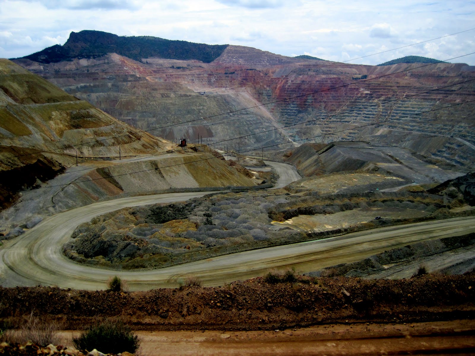
            Road to Leadville is exciting and pretty.  We climb up to Fremont Pass, amid numerous mining reclamation areas and old abandoned mines.  This area was mined extensively for a wide variety of minerals, including gold, silver, lead, etc. 
Old building in Leadville
            Leadville is not what I expected, after all the other mining towns we have found nestled in the bottom of creeks and canyons – Leadville sits on a broad plain high above the valley at 10,200’.  Wow.  We park at the visitor center, pick up some information, and then wander up and down main street , ending up at a Mexican restaurant that advertised fish tacos.  I have a halibut taco and two shrimp tacos, while Rick has a halibut burrito.  Excellent. 
Mt. Massive
            Leadville just celebrated this past weekend their equivalent of Miner’s Jubilee, and hosts this next weekend a major 100 mile long bike race, so things were hopping!  We left the trailer at a parking lot and drove down to Turquoise Lake just to see what was there.  The views of Mt. Massive and Mt. Elbert (tallest in Colorado at 14,439’) are beautiful.  Since the valley is at 10,000 feet it is hard to realize the mountains are another 4 thousand above you!  They have snow patches, but in no way are covered with snow. 
            Down the valley (emphasis on DOWN) past our exit for Twin Lakes and tomorrow’s trip to Aspen, through the narrow confines of the Arkansas River canyon.  Many rafting companies operated on this stretch of the river.  We find our Arrowhead Camping Resort five miles north of Buena Vista, check in, and get settled in a site between two cottonwood trees.  (We asked for a shady spot!)  I think we got the only shady spot available in our loop! 
Our campsite north of Buena Vista
            Afternoon spent relaxing as we do laundry (Rick) and I get caught up on photographs, blogs, and journals.  (I work for two hours and only get finished with two days!) And then?  A shower for both of us!  That sure felt good!  We basically snack our way through a light dinner as we ate a good meal at lunch time in Leadville.  Talk on phone with Luke and Mom Mac – we have cell reception, although spotty at times.  Jed texts us to say he is safely in Albuquerque, and then later, safely in Socorro. 

Tuesday, August 9:
Click HERE to see today's pictures

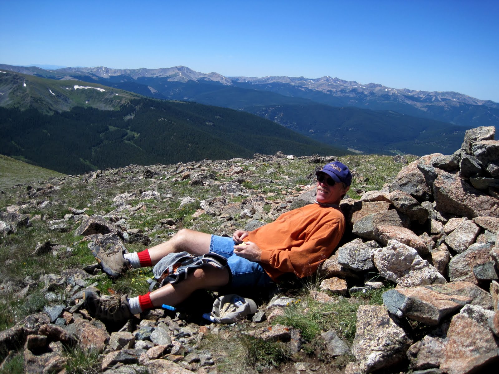
Rick and Ginger on top of the world!
            What a beautiful day in paradise!  Yesterday afternoon when we checked in to the campground, Rick picked up a couple of brochures on hiking and car tours in the area.  They proved to be one of the best investments of the trip (and they were free!)    He found a car tour to Cottonwood Pass with a 3 mile one way hike along the Continental Divide Trail to a couple of summits at 12,600 and 12,800 feet.  The pass was at 12,100’.  Wow!  What a glorious hike it was!
            We breakfast and then drive south into Buena Vista, Rick stopping so I can pick up a coffee.  Then we drive east of town to a scenic overlook that was also advertised in the car trip pamphlet.  Well, it charged, but since we only stopped long enough to take a couple pictures, we figured the pay station didn’t apply to us.  Hope we didn’t cheat Colorado out of its money!  The view was of the 10 14ers lined up in a row in this valley.  Pretty impressive, but since they don’t have much snow and the valley is at such a high elevation, you don’t get the sense of grandeur you should probably.  I think it just looks like the Elkhorns west of town!  They are 10,000 feet above our 3500’ valley, and these are 14,000 above this 8,000’ valley!  That’s about the same thing! 
            We drive up Cottonwood Canyon, past the hotsprings and Cottonwood Lake, past Rainbow Lake Resort, and then several beaver dams.  We are supposed to maybe catch a glimpse of mountain goats or sheep on the hills, but we don’t see those.  (We did see a deer in town about a block past a “Deer Crossing” sign!)
Sign at top of Cottonwood Pass
            Eighteen miles from Buena Vista you summit at Cottonwood Pass, one of the highest PAVED road passes in the country at 12,100’.  What a view of mountain peaks all around us!  Trails take off both north and south, and we take the south one for three miles to the top of a peak which we figure is at 12,800’.  (Confirmed now with a visit to Google Maps and Cottonwood Pass topographical) Enroute we visit another summit at 12,600’ where I build an inuksuk for Luke.  On the way back down to the truck, I go to the top of the “Little Summit” (my name for it) at about 12,200’ – just so I can say I hit them all! 
Wildflowers, Lost Lake, and Jones Peak
            We are at the top of the world – literally!  Above the treeline and into the tundra alpine flower world.  Everything is small and the wind blows constantly!  We are glad we have our windbreakers AND another long sleeve shirt.  Especially in the morning with the coolness, the west wind on the ridge is relentless and COLD!  Both Rick and I found ourselves nursing our right ears.  It was a bit of a brutal mile or so right on the west side of the ridge.  As soon as we crossed a saddle and entered the lee of the main summit, it was like entering a different world – no wind, the entire selection of wildflowers seemed to change, and we shed our windbreakers for the ascent to the top of the peak. 
            The top of our grassy summit with rock cliffs on the east side is broad and flat!  A rock cairn is built at the top and we use it for slight wind protection while we sit down and have a MOST SCENIC lunch break. 
            The wildflowers today are hard to describe!  So many, some of which I still have to identify.  But I shall try to list what I did know:  red paintbrush, sulfur paintbrush, dusky penstemon, a white penstemon, tall purple penstemons, yellow alpine avens, white mountain avens, purple fringe, king’s crown, yellow stonecrop, globeflowers, rocky mountain columbine, alpine forget-me-nots, chiming bells, mountain harebells, leafy purple aster, fireweed, elephant heads, moss campion, pearly everlasting, bistort, alpine sandwort, alpine phlox, alpine springbeauty, alpine sunflower, shrubby cinquefoil, and other yellow daisy like flowers that I haven’t identified yet.  Whew!  Awesome it was!
            Before we took off on the hike, coordinators for the Rocky Mt. Bike Race arrived at the top to see up a station at the pass.  The bike race starts on Thursday I think, so this was just a training run maybe.  Anyway, they put up two tent canopies and tied them together.  When the gal went to get the stakes to anchor them down, the wind gust came and it was like a giant kite sailing toward the guardrail and off the edge of the pass.  Another lady grabbed, it knocked her down and she hurt her knee, but they managed to grab the canopy and keep it from just sailing away!  It broke the frame of one and we helped them crash them down.  Offered first aid bandaids to the one lady, but she said she had some and could take care of her owie.  Like I said, the wind was BLOWING!!! 
            We arrive back at the truck at 1:45 and drive into Buena Vista, stopping for groceries before heading north to our campsite.  Quiet afternoon, showers, writing and reading and dinner of smoked salmon (thank you Amber Martell!), fresh corn on the cob, and whole wheat French bread.  Good meal topped with a little wine. 
Does life get any better than this?
            Since the Collegiate Range of 14ers is just to the west of the campground, the sun sets early in these parts! We will hit the sack early as tomorrow we are planning on driving the 60 miles or so to visit Aspen and Twin Lakes region. 
This has been a most perfect of days!  The skies were blue all afternoon – we didn’t have to worry about thunderstorms or lightning (maybe tomorrow according to the weatherman!)  Should be clear skies tonight and we shall again sleep to the rustle of the cottonwood leaves and the clicking of the branches as they rub on the roof of the tent trailer!  G’night!