5.1.16 Sunday
Bryson City to Sylva, NC
34 miles
Well, this was a strenuous travel
day!! We had to be out of Smokey
Mountain Meadows by noon and I think we pulled out at 11:30! Good timing to avoid the church traffic
coming up the hill, however! (Altho I
did say a little prayer as we headed out that we won’t encounter any uphill
traffic on the way down….and God provides!)
Couple more heavy rain storms during
the night but no thunderstorms nearby.
But by the time we were ready to pack up, the sky even had some patches
of blue!
 |
| Courthouse top! |
We drove through downtown Sylva,
just to get the lay of the land. Cute
little town with an awesome courthouse set up on a hill. It was behind me so I couldn’t get a very
good picture. Actually, it looks like a
picture of the trailer tipping over and the courthouse tower sticking up from
the top!
We stopped at the Walmart to pick up
some groceries and then found the windy little cut-off road to take us back
over to US23 south to our campground. It
is not the fastest cut-off and definitely not convenient for heading south as
we had to head north and make a U-turn to head south! Hmmmm.
 |
| Fountain pond across from campsite. |
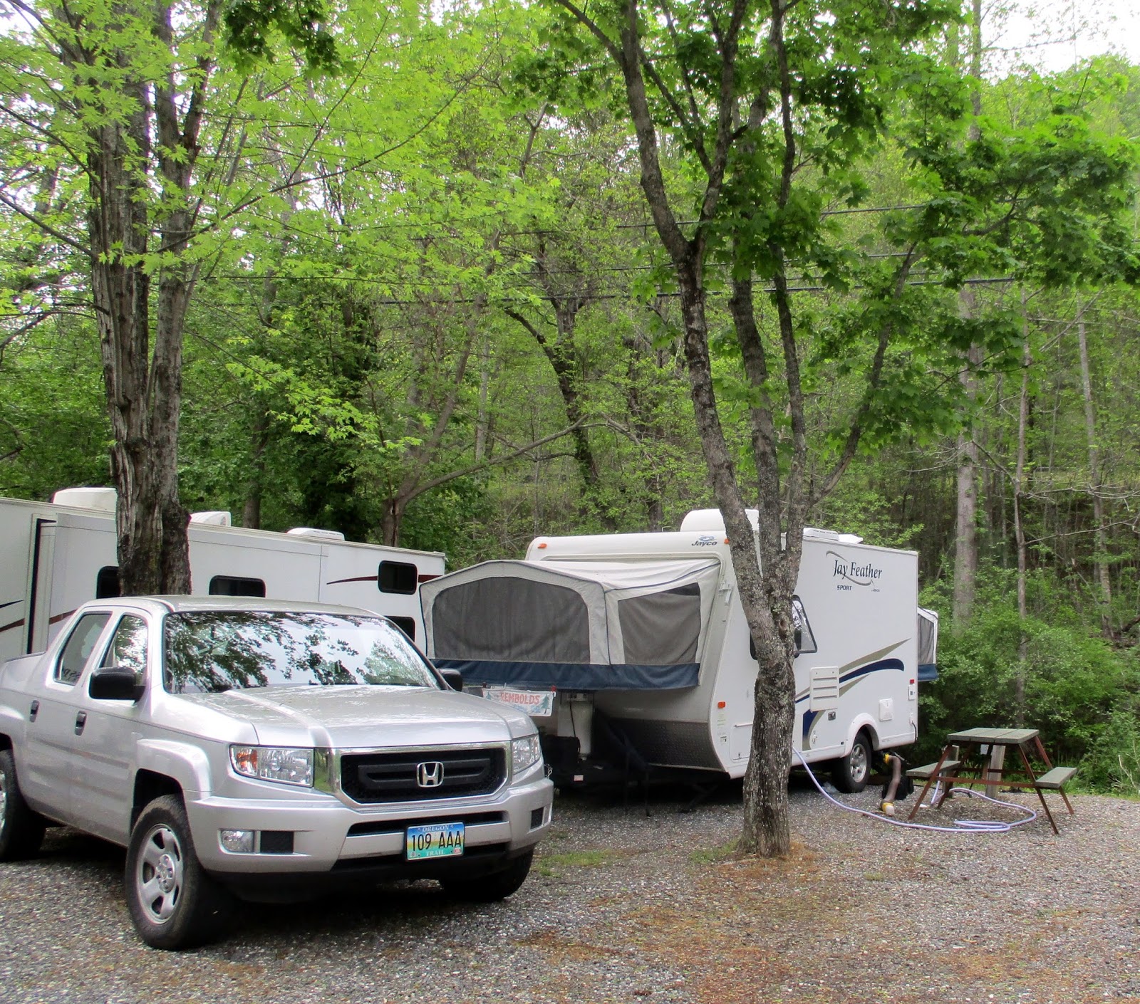
No one in the office at Fort Tatham,
but as I am calling with Rick’s phone, we see the information on the counter
with REMBOLD written across it and site #35.
I did talk with Paula, however, and she said her husband was somewhere
on the grounds. He came down as we were
backing in. A short site, but right on
the creek, so once again the beds are close to the white music of the
water! By the time you add the splash of
the fountains in the pond across from us, you think it is raining all the
time! Only in the trailer, you can
definitely tell when RAIN is hitting the roof!
 |
| Our home for the next week. |
A lazy afternoon. Rick has cell coverage, I do not. So we use his phone to call Moms. Short walks around the park, which is half
short-term sites like ours, and many full-time park model trailers. New owners.
Bathrooms are immaculate and grounds well maintained. Internet, however, has been very spotty so
far, and no cable TV. Rick was disappointed. We did find a TV up in the lounge, rec
room. He might not have a lot of
competition for it! Lots of books for
exchange though!
 |
My bed once again hangs over a stream -
this one doesn't babble, it sounds more
like steady rainfall! |
But we did pull out the little
electric grill tonight and actually cook a dinner meal! We had picked up some huge chicken breasts
which I cut into tenders and marianated.
Along with a sweet tater and some very moist and seedy bread, we dined
well.
I tried re-booting my phone and got
coverage! AT&T, but at least I could
call Marg back!
5.2.16 Monday
Hiawasee, Georgia Excursion
Hamilton Gardens
Circa 110 miles
 |
| Green islands! |
Off on another adventure today to
the state of Georgia! It is just an hour
drive south (about 50 miles) from Fort Tatham and just across the Georgia-North
Carolina border. The surprise of the
trek was the up and down nature of the road.
These mountain ranges must not run in an east-west corridor where you
can drive up a river valley. No….up one
hill to a ‘Gap’ and then down, only to climb back up again. Each seems to be at least 6% grades and many
are 8%! Again…at one of the Gaps, the
Appalachian Trail intersected the road.
The clouds of the morning were eerie – at one lookout we had a view over
the tops of the clouds to a sea of green islands. On another section of road we were IN the
cloud. But… no rain!
 |
| Rick, Margaret, Elizabeth and Ron |
We pulled into the Hamilton Gardens
exactly at 10am! Ron, Margaret, and
Elizabeth were waiting for us (we might have been early, but we missed the turn
the first time! Oops!) The gardens sit
atop a hill overlooking Lake Chatague, a reservoir of the Hiwassee River. (Don’t ask me why, but it is Lake Hiwassee,
Hiwassee River, but the town of HiAwassee!)
Many of the rhododendrons were transplanted here over 20 years ago. The hillside sloping down to the lakeshore is
literally covered with trees, moist forest underplants such as trilliums,
Solomon’s seal, columbine, etc., and hundreds of rhododendrons and azaleas of
every imaginable color, size, and variety.
No entry fee this year as they are in the process of trying to upgrade
some areas. We made a donation, but I
was sorry they didn’t have a little shop because I would have liked to purchase
a few postcards and a souvenir pin!
 |
| Hamilton Garden flowers |
We wandered the trails…all of
them! None of them long, but just wide
easy graded paths winding through the flowers.
Memorial benches are EVERYWHERE!
No lack of a place to sit down and just enjoy the view, rest, or
meditate. We wandered, took a TON of
pictures (we gals, Rick and Ron just looked!) and exclaimed over the colors or
size or details here and there!
 |
| Me and my big sister! |
Back for lunch in the shelter at the
top of the hill – Margaret had packed sandwiches, and I had brought fruit and
chips. No one starved! Then we attempted to plan our next move and
found a short mile hike close by. But by
the time we drove over, the rain started to fall and a rumble or two of
thunder. We decided right along a lake
wasn’t the best place to be caught in a T-storm. So…a drive through ‘downtown’ Hiawassee which
didn’t really reveal a place to window shop, gift stores, etc. No museum or craft market. So…we ended up at McDonald’s, Rick and I
bought everyone hot fudge sundaes, and we sat and talked for another hour! Lots of exciting things happening at the
Georgia Mountain Fairgrounds, just not on the first Monday of May! The Eggfest is in two weeks! What in the world is an eggfest? I don’t know!
But it sounds interesting!
 |
| Caught on the rock! |
`So around 2:45, Taylors headed
south and we went north! I drove Rick
and I back up to Fort Tatham, this time taking the bypass through Franklin just
to check out the town. Hoping to find
the little brewery Rick wanted to visit or the Scottish Tartan Museum I would like
to see. No such luck. Home at our little trailer by 4.
Evening spent reading, listening to
two more thunderstorms hit between 6:30 and 10pm and once again going to bed to
the sound of the pitter patter of raindrops!
Rick escaped for awhile to watch the Pirates on TV up in the rec
room/lounge. He came back AFTER the
deluge but still in a good rain.
Tomorrow we head toward Asheville,
Montreat, and perhaps a journey along the Blue Ridge Parkway on a section we
haven’t done before. Should be exciting!
Raindrops keep falling every
night!!!
5.3.16 Tuesday
Blue Ridge Parkway-Appalachian Folk
Center-Montreat
Circa 210 miles
Wow! We did a
lot of miles today for a non-travel day!!
And except for a short 8 mile section, ALL of it was on non-interstate,
much of it two lane back country roads!
 |
| Our circle route for the day of SW North Carolina! |
We left around 9 heading up to Sylva
and a short drive to the entrance to the Blue Ridge Parkway section south. Three years ago we did the north section from
here to the entrance to Smoky Mt. National Park. This time we wanted to do the longer 65 mile section
to the Folk Art Center outside of Asheville.
The morning was cloudy, but the rain had stopped and blue sky was even
poking through in places! As I went to
take my first picture, I realized I had left the media card in the laptop after
drawing this morning’s picture.
ARGH!!! The spare is NOT in the
glove compartment, so I will have to use the phone today!
 |
I have to confess...I didn't take this picture.
Just this is what it WOULD have looked like! |
So…our drive up and up, then down,
then up and around, was in a fog much of the beginning. There were overlooks everywhere, but looking
out on a white world. At times, we would
drive above the clouds, but most of the time we were in them – at least on the
first half of the drive. Walls and walls
of rhododendrons on steroids – HUGE trees of rhoddies. Some of the azaleas were in bloom, but the
rhododendrons need another month to be in full bloom. It was beautiful and
eerie.
A
few parkway facts gleaned from the internet:
- Begun
in 1935, finished in 1987 with the Linn Viaduct in NC (which we traversed in
2013!)
- Four
hundred sixty nine miles through Virginia and North Carolina
- High
point is 6053’ at Balsam, NC (which we went over today!)
- There
are 27 tunnels, of which 26 are in North Carolina. All are through solid rock. (We went through
at least 10 of them today!)
- There
are 168 bridges and 6 viaducts.
- The
speed limit is never more than 45 mph, and sometimes slower.
- It
is the most visited National Park in the country with 19 million guests a year.
 |
Typical views for first half of drive
on Blue Ridge Parkway |
We pulled off at Graveyard Fields,
site of a violent wind storm that broke off trees, leaving ‘marker’ stumps
covered with moss – until a 1925 fire burned everything and sterilized the
soil. Trees in places have recovered
over the past 90 years to about ten feet tall.
Lots of trails available if you want to hike from nearly every
overlook!
 |
| Barren landscape of Graveyard Fields |
Fortunately, the skies have
cleared somewhat and we have good views for the rest of the drive!
The parkway was a nice route through
the busier sections of southern Asheville as we wound through the trees to the
Folk Art Center at MP385. This is the
single most visited site on the BRP. My
only regret here is I can’t take pictures
and some of the artwork is
incredible. I found a print I loved with
a quote on the pines. Sadly it was
$265. (And no notecards available in
that design!) Bird sculptures made from
pinecones – so realistic and animated!
Needlework, wood carvings, paintings, basketry, you name it – artists from
all over the country have work showing, but largely over 900 artists from the
southeast US. Nothing very cheap! So we visited the national park gift shop
instead and picked up some Christmas ideas!
 |
| Entry arch to Montreat |
Out highway 70 toward Montreat! We stop at Burger King for a quick bite to
eat, and then attempt to find a road that at least indicates ‘Montreat’ on the
sign! Finally stop at a visitor center
to inquire! The nice lady assures me we
were on the right path and we head up the road!
Part of the confusion is that Montreat is a town, a conference center,
AND a college all wrapped up in the same location. Buildings are shared at
 |
| View across lake from shops |
times, but belong to
one or the other. The college area was
busy as folks are starting to arrive for the graduation this coming weekend. The conference
center was hosting a ‘recreation
and arts’ conference (that sounded interesting!) You enter through a set of rock arches that look like a giant M.
We found the Moore Center (online search had revealed it was the site of the
gift shop and Thousand Villages store!).
We explored both stores and asked a lot of questions about the
conference center.
 |
| Four inch high iris! |
Since it was 2:30 by the time we
left the shops, Rick suggested we take a hike on the grounds rather than trying
to hit the waterfalls on the way home.
 |
| At Woodword Falls in Montreat |
Great idea! We drove on up the
main road more, past the hotel and ‘lake’ (very small!), and to a series of
trailheads at the upper end of the road.
We found a 2 mile loop that traversed 4 different trail sections and
visited a waterfall. It was mostly in
deep woods walled with rhododendrons (again, not in bloom yet!) Did find some tiny iris blooming! And warnings about picking galax. The
trails are all on Montreat property. We
had NO idea what galax was! (Google
later reveals a woodland plant that is being overpicked for sale to florists. I don’t think we saw any!)
 |
| Whiteface Mountain near Highlands, NC |
 |
| BridalVeil Falls |
Time to head home! We don’t want to take the expressways or interstate
through Asheville. It is nearly 4:30 and
getting close to rush hour time. So a
few miles on 70 and I-40 take us to US280 and travel southwest toward Brevard,
NC. There I told Rick I would drive for
awhile. Little did I know what I was
saying! US Route 64 from Brevard to
Franklin, NC is the curviest section of road we have traveled this trip! Tight curves!
Up and over ridges and through gaps.
Past small villages and huge resorts, golf courses, and housing buried
deep in wooded hills. I would laugh
because the 55 mph speed (rare!) was immediately followed by ‘Slow to 20 for
curve’. The lowest speed curve was a
posted 15mph! I haven’t driven a road
like that in years! We opted to stay on
64, thinking it would smooth out toward Franklin and was a more major road than
107 heading north to Sylva, but…. I think 107 followed a river more so it might
have been the smarter choice. It was
only 2 miles shorter though. Oh well –
beautiful country!
We got home at 7:20, VERY
ready for a bite to eat! I spend part of
the evening trying unsuccessfully to get my phone pictures to transfer to the
laptop. Internet won’t do it, direct
cable doesn’t seem to work – or I don’t know how!
After a cloudy morning, the day sure
cleared off nicely! It is forecast to be
at least 10 degrees cooler tonight!
Hallelujah!
5.4.16 Wednesday
Visit to 'The Cabin' - Rob & Karen!
A night without raindrops? Yes!!!
I sit typing looking out my window at the sun rising over the hilltop,
the sounds of the stream and fountain musical against the trucks on the
highway! (J)
Good news from bad news! In trying to open an email from Katy, I got
my phone to sync and yesterday’s photos are now loading! But prayers are on the wind for Mike and
Judy.
 |
| The 'cabin' Robs rented for the week. |
We spend most of the morning
cleaning house, fixing Rick’s window shade, repacking under the seat, and
unwinding. Rick calls Rob and sets up an
11:30a time to meet them, see the house, and then go to lunch together.
Back again. A good day!
We met Rob at the Holiday Inn where he led us up the steep and windy
road to the top of the mountain behind the inn (or at least it seemed like the
top!) to the house he and Karen have
rented for the week. And what a log
cabin it is! Lodge is more like it. Only 3 bedrooms, but it will sleep 12 plus
two couches! Rob, Karen, Meg, Kurt, and
most of Karen’s family will be staying there.
They are hosting a huge party on Friday night (circa 80
 |
| I think my favorite is the rock breakfast bar! |
expected!) so
the two decks, game room, and large main floor will be welcome! Let’s just hope for warm dry weather! (But not HOT!) The house is surrounded by trees, but you do
have a view out one side to distant green hills. Rick and Rob took the truck back down to the
gates to pick up the flowers that had been delivered and left there. Karen and Meg were in town having manicures
when we arrived.
Rob drove the four of us down the
hill to meet Karen and Meg at Kostas, a Greek restaurant in Dillsboro. We had a great meal. I tried something new – a Gyros Sandwich,
which was beef and lamb, onions and tomatoes, with a tzatziki sauce (Greek
yogurt and cucumber). I opted for fruit
instead of French fries. (I’m TRYING!) I
really enjoyed getting to know Kurt, Megan’s significant. He is a postman in Pittsburgh and very easy
going.
 |
View from upper deck down to the flower
processing. Fiance Kristen is far right. |
Then we met Kristen, her sister
Amber, and Heather a good friend from Oregon!
They had driven up to Sylva to process the flowers and check on a few
other details. We helped cut the ends
and put them in water. She will be
getting another shipment tomorrow.
A chance to just sit and visit with
Rob and Karen for awhile before we left.
They had errands to run and were driving Meg into Asheville tonight for
Kristen’s bachelorette party. (Two
friends are pregnant, so Kristen said it would be pretty mellow!)
 |
| Abandoned barn on walk |
Back at the trailer and we took a
short walk up the road and hill from the campground – there are more houses
back there than you can imagine. Some
very old and others newer. A little
creek runs down along the road. We went
until the road ended in a driveway or at a gate to Cove Creek ‘Estates’ (I don’t
think developed yet!)
Agh….raindrops are falling, but at
least they are again falling at night!
Forecast is for much cooler tonight.
Might have to get the heater
out,….just in case. We stowed the heavy
sleeping bag away so no chance there!
5.5.16 Thursday
Franklin Adventures
Brrr!! It did
cool down again last night – trailer was a brisk 46 when I got up this
morning. We had every blanket on the
bed, but did NOT get out the heater. I
might change my mind about that for tonight!
Hopefully things will warm up before Saturday’s wedding, but today was
forecast to be cool and rainy off and on.
 |
| Lower Cullwohee Falls |
Hence….we didn’t get moving too
fast! But finally around 11 we head down
the road toward Franklin with the intention of waterfalls, lunch, and the
Tartan museum!
Thankfully Rick got to drive the
windy stretch of 64 today, at least for the 7 miles of twisty we had to drive
to get to Dry Falls. We stopped enroute
at Cullowhee Gorge to see the lower falls.
Dry Falls was awesome. About 75’
drop and the trail down goes behind the falls.
WET! Plenty of water pouring over
the top!
 |
| Dry Falls |
Back into Franklin and we cased out
the downtown. Found the Tartan Museum on
Main Street and then backtracked to the La Casa Restaurante to enjoy a Cinco de
Mayo lunch! We both brought home
leftovers for tomorrow! I tried a
Quesadilla Pizza which was quite good!
 |
Rick walks behind
the falls |
The Tartan Museum was
fascinating. Rick went into the gift
shop with me, but declined to pay the $2 admission into the downstairs
museum. Mostly it was a history of
tartans and the garments of the Highland Scots (the lowlanders didn’t wear the
same outfits!) North Carolina has one of
the highest concentrations of residents with Scottish-Irish-Celtic backgrounds. I read through the description of how to turn
the 5 yard long piece of fabric into the ‘skirt’ and pack, or in cooler weather
to drape the remainder over the shoulders, etc.
There are different pleats patterns for the kilt as well as
tartans. The tartan plaids were not
specific to a certain clan until well into the 1800’s. I picked up a few treasures from the gift
shop and then met Rick back down at the book store where he had been
browsing.
 |
| Highland Tartan wear |
A long HOT shower plus discussions
with the campground manager (and a refund on our overpayment!). Around 6:30 we met Rob and gang back at Kosta’s
Greek restaurant for dinner. Megan and
Kurt are in Charlotte at Matt’s bachelor party.
First time Mom has been together with three of her sons and wives since
Pop’s service in 2010! We got a table
out in the patio area, but Mom was RIGHT under the heater so she was warm
enough! Good meal and we visited for two
hours! Fun to just listen to the ‘boys’
reminisce – and everyone giving Randy a bad time about his eating habits (or
limited menu!)
Time to hit the sack!
5.6.16 Friday
Wedding Welcome Dinner
Today truly was a lazy day! We hung around the campground and did
laundry! Light rain early in the morning
and then the skies cleared. Still cool,
but the sun is shining. Rick took a walk
in early afternoon. We visited with a
seasonal gal doing her laundry as well.
I started checking for campgrounds for the trip home!
 |
| Walking Sadie |
We left around 3 to pick up wine and
ice at Wal-Mart and then truck up the hill to the cabin. The welcome dinner started at 6 but we wanted
to make our delivery and then get the truck parked out of the way out of the
driveway and down the hill. Talked with
Grandma and Patty for abit, and then offered for Rick and I to take Sadie on a
walk before the festivities really started.
Rick and I headed UP the hill toward
the top, finding three more very nice ‘cabins’ along the way! Most of these are rented out through the
agency. The hill is steep!! Last two roads we traveled were gravel, not
paved. A little good exercise before the
dinner….
 |
| Rob, Meg, Matt, and Karen |
….which was delicious!! The caterers were two guys, John and Ron, who
brought in BBQ pork, chicken, mac & cheese, cole slaw, fruit salad, baked
beans, and two huge veggie and fruit trays with dips. Rob and Karen had provided the beer, pop, and
waters. Rick and I picked up 4 1.5
liters of wine and someone in Kristen’s family showed up with another 6 large
bottles! Plenty!! (In fact, Rick brought home our unopened
Merlot!) Grandma had spent the morning
making scotcheroos – enough for 80!! The
same caterers are doing the wedding today, so I know the food will be great!
 |
| Kurt and Megan |
Rick took the van keys from Matt and
Rob so they could enjoy their guests and he made two trips down the hill to
pick people up and another two trips taking folks back down to the hotel. The Holiday Express had nicely agreed to let
people park there and get picked up for the narrow twisty road to the top of
the mountain. Same hotel where Mom, Ran,
and Patty are staying. On his last trip
to bring people up, Rick was followed by a truck that had a full cab load AND
the pickup bed filled! Lots of Matt and
Kristen’s friends from grad school, Matt’s from Cinci, and Chicago friends made
the trip to NC for the wedding. It was a
great gathering of young people, relatives, etc. Karen’s two sisters, plus two of her brothers
came, Kristen’s aunts and uncles, both of her grandparent sets, plus all of us
Rembolds. Got a few pictures, but never
one of Kristen and Matt together! (They
were making the rounds separately most of the evening!)
We stayed until 10:30, however! Late night by the time we got back to the
campground!
 |
| Rob, Karen, Ginger, Mom, Rick, Randy, Patty |
5.7.16
Saturday
WEDDING
DAY for Matt and Kristen!
I’m not sure I could get much lazier
this morning! I didn’t even get ‘dressed’
until I showered at 1:30 to start to get ready for the wedding! I spent time on my prayer drawing, I looked
for campgrounds on line, I finished reading a book. We talked with Luke on the phone as he drove
down to Ontario for tennis, I talked with my mom on the phone.
 |
| Pond and azaleas |
 |
| Megan stands with her brother. |
At 4pm we drove the short half mile
down the highway to the turnoff for Betty’s Creek and followed the windy road
up the hill to the Vineyard. A beautiful
setting on the side of the mountain looking to the east and the rolling green
hills. There were two sections of
grapevines, a half dozen small buildings tucked in here and there, and a lodge
and pavilion. The wedding ceremony
itself took place in a grove of trees in from of the wine cellar house, a
towering rock chimney to one side. It
was simple – recorded music. Matt had
just Megan standing by his side. Kristen
three friends – all of whom picked their own dress to wear, as 2 of them were
pregnant! The third was her sister,
Amber. Below and behind them was a
series of ponds and deep orange azaleas in bloom, which reflected in the pond
surface. It was shady and a little
breezy at times, but lovely.
 |
| The happy couple! |
One part of the ceremony which was a
little different – they had asked two people to give advice on marriage. One was a friend who had just married 7
months ago – a fresh perspective. The
second was Kristen’s grandmother, married for 62 years – what it takes to make
it last. Pretty special.
 |
| A wedding kiss... |
After the ceremony, while pictures
we being taken, everyone went up to the lodge and the outdoor courtyard for
cocktails, hors d’oervs, and the watching of the Kentucky Derby! Mini hats were available and many of their
friends were
wearing bow ties, etc.
Pretty cute! The tables in the pavilion
were set and labeled by the names of previous derby winners and cards with
names and horse winners were available so you knew where to sit at dinner. Rick, Rand, Patty, and I were all at ‘Gallant
Fox’ the 1930 derby winner. Cocktails
were mint juleps and another that I can’t remember, but it was cranberry. I had a virgin one of those! Especially enjoyed the fried green tomato
appetizers!
 |
| The younger set! |
Several of Matt and Kristen’s
friends had little children – two little girls were especially all dolled up in
their Disney princess dresses with big hats.
So adorable to watch them play among the vine yard. Another little 2 year old boy with suspenders
and his bow tie.
Dinner was excellent, served family
style. Only problem was the entrees came
rather separately so you weren’t sure how much to take of anything! Mac and cheese, collard greens, trout and grits, pork loin with a fruit salsa, salad and roll. The grits were the best I have ever tasted –
thick and creamy!
 |
| The cookie table |
A tradition of western Pennsylvania
weddings is to make cookies rather than a huge wedding cake. Karen and Megan had baked over 900 cookies
which Karen brought down in two large coolers with dry ice. A wide variety of fancy options! Plus little take home bags afterwards!
They had a Derby photo booth set up
in one corner. Lots of fun props,
including a horse head, a camera that you could set yourself and a little
printer on the table. We never did go
over, but Karen and Rob got some terrific pictures.
 |
Matt and Karen on
dance floor |
Rick and I danced – the music was
very definitely a younger set, but it was amazing how well this set knew the
words to some of the older tunes. Rick
requested Unchained Melody, but alas, it never was played. Still lots of fun – kids were having a very
good time!
It was a beautiful evening – a little
cool, but the pavilion had heaters in the corners. We sat Mom down there!! Dancing, I took off my sweater and was just
fine in my dress only. As we left at 11p
(they were closing things down), the stars were bright in a clear sky.
 5.8.16 Sunday
 Randy, Patty, and Mom came by just
as we were getting ready to leave. So we
drove up to the hotel, parked the trailer and hopped in with them for the trip
back up to the cabin. Randy had called
Rob and he said to come up because they had plenty of food in leftovers from
Friday night! So….we got a chance to say
goodbye to everyone except Matt and Kristen.
Randy and Patty were taking off for Atlanta and their flight home, Kurt
and Megan driving back to Pittsburgh today (Kurt has to work tomorrow).
Randy, Patty, and Mom came by just
as we were getting ready to leave. So we
drove up to the hotel, parked the trailer and hopped in with them for the trip
back up to the cabin. Randy had called
Rob and he said to come up because they had plenty of food in leftovers from
Friday night! So….we got a chance to say
goodbye to everyone except Matt and Kristen.
Randy and Patty were taking off for Atlanta and their flight home, Kurt
and Megan driving back to Pittsburgh today (Kurt has to work tomorrow).  So….we left at 12:30pm and pulled
into Woods n Waters Kampground about 40 miles south of Indianapolis, Indiana at
8pm! Rick did most of the 430 miles, but
I drove from Knoxville, TN to London, KY!
We encountered a lot of hills, green trees and construction. More flatlands once in northern Kentucky and
Indiana! Gas prices are climbing – trip home
will not be as cheap as the trip east!
Chatted with Luke for awhile around Louisville, KY and then with Jed
after we arrived at the campground.
So….we left at 12:30pm and pulled
into Woods n Waters Kampground about 40 miles south of Indianapolis, Indiana at
8pm! Rick did most of the 430 miles, but
I drove from Knoxville, TN to London, KY!
We encountered a lot of hills, green trees and construction. More flatlands once in northern Kentucky and
Indiana! Gas prices are climbing – trip home
will not be as cheap as the trip east!
Chatted with Luke for awhile around Louisville, KY and then with Jed
after we arrived at the campground. 
 We put all our eggs into a
campground just west of Des Moines, largely because I couldn’t get on the
internet on the phone to check out a couple of others. So…it is very nice but we ended up paying a
pretty price of $40!! For a ‘less than
12 hour’ stay!
We put all our eggs into a
campground just west of Des Moines, largely because I couldn’t get on the
internet on the phone to check out a couple of others. So…it is very nice but we ended up paying a
pretty price of $40!! For a ‘less than
12 hour’ stay! 


 Our hundred miles to Nebraska were
marked with bluffs and wind turbines! We
passed two large turbine farms. Rather
ironic to see the power farms sitting in the middle of the agricultural farms –
double use for the land!
Our hundred miles to Nebraska were
marked with bluffs and wind turbines! We
passed two large turbine farms. Rather
ironic to see the power farms sitting in the middle of the agricultural farms –
double use for the land! 


 Ah, there’s no place like home! No smell like when you walk into your cool,
clean house and know you are back at HOME!
But first, we had the shortest of our five days to travel!
Ah, there’s no place like home! No smell like when you walk into your cool,
clean house and know you are back at HOME!
But first, we had the shortest of our five days to travel! 

 We welcomed the Oregon sign at the
Snake River crossing! The last state of
our ten state journey home! And then a
quick stop at Walmart for a Subway sandwich and a few groceries to restock the
fridge at home. Perhaps it was the
Walmart stop we were going to make last Sunday and never did?
We welcomed the Oregon sign at the
Snake River crossing! The last state of
our ten state journey home! And then a
quick stop at Walmart for a Subway sandwich and a few groceries to restock the
fridge at home. Perhaps it was the
Walmart stop we were going to make last Sunday and never did?