Friday, November 1, 2013
Lewisville,
NC to Cherokee, NC
River
Valley Campground
217
miles
 |
| Our route for 11.1.13 |
We are
heading west!! Really west now!! Arise and pack up early, and ready to roll at
7:30 from Rob and Karen’s. We want to be
out of their way, as they are packing up and heading eastward around 9am!! The day is still darkish, still on Daylight
time, and the clouds have come in, but no
rain….yet!
Pick
up a coffee in Lewisville, down to I-40 and the quick 40 miles down to Statesville
where I found a Sheetz gas station….cheap and 3 cents more off. Plus we should be close to earning our FREE
drink! Refill the coffee cups and I take
over the wheel for the 100 miles down to Asheville.
 |
| I couldn't take pictures INSIDE the Folk Art Center! |
I
drive into the storm! (It was
forecast!!) At first just a drizzle, but
then pretty constant rain for the next hour.
I remember commenting around 9am that it didn’t look that much different
outside. The sun wasn’t breaking through
AT ALL and it was so gloomy!! But…the
further west I went, I could gradually see a lightening in the sky and then….a
patch of blue. I told Rick I was going
to keep driving toward the blue patch!!
By the
time we turned off onto the Blueridge Parkway just before Asheville to visit
the Appalachian Folk Art Center, the sun was shining and it was a gloriously
beautiful morning!!! My biggest
disappointment of the day was that no photographs were allowed inside the
center. There was a special exhibit of
weavings and I so wanted to take a few pictures. Not even any postcards available to
purchase! One was a 3D image of a maiden
surrounded by flowers, all crafted from woolen yarns and woven together. My favorite, however, was called Tumbling Waters,
and it was also 3D, but still a landscape.
The boulders protruded outward, the water had texture, it was
AMAZING!!!
So
much fun art to see, especially the kind that has existed in these hills for
generations. I got ideas….for seed
flowers, woven snowflakes, and pine cone angels. Glass and jewelry artists were demonstrating
out front. Pottery, corn husk dolls and
nativities (only $200 for the set!). I
decided our Support Group did a pretty good job 25 years ago with the one we
made for the church.
Nearly
noon as we prepare to leave and must DECIDE:
A stop to
 |
| From the Blue Ridge Parkway |
explore Asheville? The
Cherokee Indian museum? Ninety miles of
Blueridge Parkway or just 25?? We
finally say, “God has already decided!”
The day was supposed to be rainy until evening. It is gorgeous outside. We can not consider anything that will mean
INSIDE! However….we aren’t quite ready
for 90 miles of the windy and hilly parkway, but definitely 25! So….sorry to Asheville, sorry to Cherokee
Museum….the outdoors is calling us!
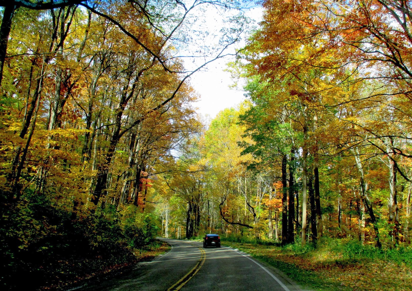
 |
| Typical Smoky Mt. picture?? |
We
drive down I-40, exit at Waynesville, and off to meet the Parkway just south of
that town. Quickly the parkway travels
UP…to the visitor center at the top of Waterrock Knob. From here we have views to the north and
south – long range views!!! The hills
are drapped with golds and reds. A few
trees have shed all their leaves but many are still covered. The hillsides are indescribable! At the Visitor Center we find a short half
mile trail UP (I emphasize that part!) to the top of the knob. We are able to add a good view back down
toward Waynesville to the northeast from here.
Lots of rhoddies still, plus Mountain Ash trees, barren of leaves, but
loaded with bright red berries. The
trail is wet since it did rain this morning!!
 |
| The road is a kaleidescope of color! |
On
down the parkway, through five tunnels and a couple more ‘gaps’ to the end of
the road at the entrance to Great Smoky Mountains National Park. The Parkway is an amazing road construction
feat – with only about 80 feet of easement on either side of the road, it has a
constant worry about encroaching development.
It was begun in the early 1930’s and not finished until 50 years
later. It is riddled with turnouts,
viewpoints, and opportunities to hike, explore, and learn. I’ve thoroughly enjoyed the segments that we
have driven.
 |
Outside Ocanoluftee Visitor
Center |
And
now…into the Visitor Center for Smoky Mountains! A quick tour of the information available,
hiking opportunities, and some of the history of the area, including a brief
overview of the Cherokee Indian situation and the Trail of Tears. It is now close to 4pm and we need to decide
about our campsite for the evening. No
phone service, so I can’t call the campgrounds I have on my list.
We
drive back into Cherokee, hoping we might SEE one of the campgrounds, but
finally call. Only one responds, and the
price is within budget, so we shall have electricity and heat this evening….and
coffee in the morning!! (Our other
option was Smokemount in GSMNP, which would NOT have provided ANY
amenities. We must be getting old!)
While cruising Cherokee we see painted bears – lots of them. The town has bear statues everywhere with a
variety of paint styles. Fun. I love it when a community finds their ‘art
niche’! As we drive out Big Cove Road,
we pass the Cherokee Reservation High School.
Wow. What a campus! Beautiful fields and buildings, but also
locked gates and fences. Interesting.
 |
Our spot along the Raven
Fork |
We
pick out a campsite along the Raven Fork of the Ocanaluftee River. The Ocanaluftee is the main river the road
over the Smoky Mountains follows into Tennessee. The trees of the campground are
beautiful. We are camped near a family
tenting….would have gone further away, but we didn’t want to walk that far to
the restrooms!
I sit
down by the river to eat my dinner of pretzels, turkey sandwich, and dried
fruit. Oh, and a glass of wine! Then a walk around the park to take pictures
of leaves. Such pretty leaves.
The
temperatures are dropping, and Rick has returned to report on ‘the BEST campground
shower of the trip’!! Hot scalding water
and plenty of pressure! (Please note,
dear friends, that says CAMPGROUND – we enjoyed all the showers you
provided!) So….I shall close off for the
evening and make a trip to verify his proclamation!! (Good, but best? Hmmmm…. Definitely well above Mankato!)
SATURDAY, November 2, 2013
Cherokee,
NC to Crossville, TN: 175 miles
Great
Smoky Mountains National Park
 |
| Farm House Museum |
Wow! What a day!
First off we slept in because it is soooo dark in the mornings right
now! I didn’t wake up until 7:30 (left
the phone in the truck so I couldn’t check time), and Rick got up around
8. By the time we left at 9, the sun was
just beginning to turn the hilltops golden.
We grab a cup of coffee and then back up to the Visitor Center to check
out the Mountain Farm Museum. When the
area was dedicated for the park in the early 30’s, many were displaced and lost
their homes. A representation of the
rural mountain homesteads were gathered and brought together to form this
museum. We saw the farmhouse, wood shed,
meat shed, chicken coop, hog pen, barn, tool shed, spring house, corn crib, etc. A herd of elk was grazing nearby and many
visitors were excited to see them. A
couple of the bulls were quite big!
 |
Near Visitor Center,
fall reflections |
 |
| Mingus Mill |
A
couple miles up the road we find Mingus Mill, an old grist mill established at
the end of a creek flowing down into the Oconaluftee River. This was a fun stop as the mill was operating
and grinding cornmeal. The volunteer
operator said their biggest problem at the time is leaves which keep clogging up
the intake! It slows the mill way
down. We watched one of the guys climb
up the ladder (after putting the lower rungs in) to clean out at least 3
separate screens. End up purchasing a
small bag of cornmeal and a recipe booklet.
 |
Mill volunteer cleans the
screens of leaves |
As we
head on up the highway, we find the colors everchanging, as well as the
skies! Clouds are gathering, especially
on the higher peaks! By the time we get
up to the top of the pass (the Tennessee-North Carolina border) the wind is
COLD and the views are closing in. We
turn off and drive the 7 miles to Clingman’s Dome.
 |
Observation Tower at
Clingman's Dome |
It is a paved ‘trail’ up to the top, but steep. It climbs about 350 feet in the half
mile. At the top of the treed dome is a
radio tower and the observation tower, which appears somewhat like a space ship
with a landing platform! It is totally
wheel chair/stroller accessible, so a curved ramp circles around to the raised
circular tower. BRRRR!!! A chilly wind was blowing and the clouds were
moving rapidly!! The sun was shining
through in scattered patches on the orange tinted hillsides. Ridge upon ridge of mountains was vvisible faintly
on the horizon. It truly looked like the
mountains were ‘smoking’ with the clouds circling around. As we left the tower, visibility was down to
about 15 feet!!
 |
| One Smoky Mt. vista from Clingman's Dome....the mountains are smokin'! |
The parking lot has filled
during our hike. In fact, we are utterly
AMAZED by the massive numbers of cars and people as we drive down the western
side of the park. Every parking lot and roadside is crammed with cars. We had thought we might take another hike,
but parking the truck and trailer was out of the question! It is a weekend and the leaves are still
pretty, especially at the lower elevation, so I guess the crowds are still
present. The weather has deteriorated
abit, so we aren’t too disappointed.
 |
| Another vista from top of dome |
I remembered later that I wanted to tell about the
pixie dust!! On our hike to the top of
Waterrock Knob yesterday, I told Rick the trail looked like it had been
sprinkle with pixie dust – it was all sparkly!
(I have been commenting on the diamond roads throughout the east – there
is SOMETHING in the asphalt that makes the highway sparkle!) As we drove down the west side of the
Smokies, we passed through a thick grove of yellow trees as the wind suddenly
caused thousands to let loose and flutter to the ground. It felt like we were driving through ‘leafy
dust’!! Rick thinks I’m nuts!
 |
| Autumn leaves along SMNP road |
We
decide to go on into Gatlinburg or Pigeon Forge for a bite to eat. We find a bypass of Gatlinburg so straight to
Dolly Parton’s hometown. The map may
list it as a town of 5900, but HOLY MOLEY!!!
It is like a massive Las Vegas strip!
King Kong, Christmas decorations, Hatfields and McCoys, Ripley’s, you
name it! Traffic, chaos, and tourism
galore. We did find a nice little
pancake house right at the beginning of town and had a great meal. After that?
Wow!
 |
| Welcome King Kong in Pigeon Forge |
It
took us a little longer to get through the Pigeon Forge – Sieverville mess, but
eventually we hit I-40 and west through Knoxville. Rick had seen the information about Oakridge
National Labs and a Museum of Science and Energy. Oakridge was about 12 miles off the freeway,
a town that was established at the beginning of WW2 to test nuclear
possibilities. It worked in conjunction
with Los Alamos and Hanford. Top Secret
stuff. Rick was interested in seeing
this third arm of that effort. A few
wrong turns, but we finally found it.
Rick only had 1 ½ hours to explore and could have used more time, but at
least we found it!
 |
My favorite painting from
Museum of Science and Energy |
Finally
stop at a MacDonalds in Harriman, TN to check for possible campgrounds (the one
I found in Oliver Springs was going to be over $41 for the night. Ridiculous, so we just kept driving!) Another half hour and we come to the
outskirts of Crossville, TN – Deer Run Resort, about 5 miles off the
freeway. And it truly is a ‘resort’ – a locked
entry gate! A bit more reasonable rate,
but on a little lake. We will get a
better look in the morning as it is nearly dark as we arrive.
 |
Sunset reflection on eastern
clouds behind truck |
Just
after Harriman, we cross over into Central Time Zone. We pick up another hour. And then tonight is the time change from
Daylight time to Standard Time. Goodness….we
will pick up two hours tonight! Oh well,
the clock may say early, but my body says it is bed time! G’night!!!
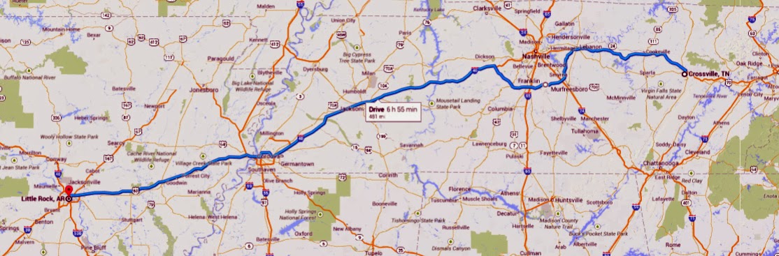
SUNDAY, November 3, 2013
Crossville,
TN to Little Rock, AR
482
miles
 |
| Route for a LONG day of driving! |
 |
| Fog on the Deer Run lake |
I keep
wondering how many more mornings we can waken to blue skies? The day dawns earlier! I hear birds singing in the trees before 6am
today! Finally, it is light early! We head over to the bathhouse (a long walk!)
for showers. Rick is successful, but I
am not. I can’t get any warm water, my
sink only stays on for 2 seconds at a time, and the auto towel dispenser gives
you 3” towels. Grrr. I sponge off, refusing to take a cold shower
when it is barely above freezing outside.
Rick offers later to walk back with me to take a shower in the men’s
side, but by then I am dressed and ready to roll. I decide not to let it bother me! (However….I will send an email to let them
know if was not satisfactory for $33 a night!)
 |
| Kudzu figures |
 |
| Memphis pyramid |
We are
on the road by 8am with a quick stop just before the freeway for gas and
coffee. Rick drives about 60 miles to an
information center/rest stop and I take over for the 75 mile bypass of
Nashville (to the south). We are on
Interstate 40 for the next four days, so our travels are mostly wide ribbons of
highway with trees. What do we see today
that is different? Cotton fields (more
in Arkansas), lots of rivers and lakes (Tennessee), Kudzo plants covering
EVERYTHING in places along the freeway.
The kudzu ends up looking like giant fantasy creatures, engulfing trees,
telephone poles, you name it. We cross
the Tennessee River, the Mississippi River.
We see the huge Pyramid in Memphis, later to learn that it is a
boondoggle for the city. It was built as
a sports arena, convention center, etc. but has been abandoned for years. In Arkansas the highway is lined with unknown
green vegetation, with highlights of sumac in a variety of golds, oranges, and
deep reds. Really pretty.
 |
| Sumac |
We
stopped in Jackson, TN to gas up the truck and fuel our bodies as well! A Denny’s was located at the Pilot. Great meals for inexpensive prices! I ordered off the senior menu which means
plenty of food for cheap.
As we
sailed past our original goal of West Memphis, I went to call the KOA in Little
Rock for details of a reservation. I
realized I had left a number off my ‘smart camera’ screen shot. Rick suggests I use the ‘smart son’
phone. So I call Jed, who gives me the
correct number! When I called, the KOA gal
quoted me a price of $39!!! Way over the
internet quote and over budget! So I call
my smart phone son back and he checks the internet for some other options. I get through to Riverside RV….reservation
made by phone.
 |
| Looking west from RV park to I30 bridge over Arkansas River |
The
setting sun in the west was making driving a challenge as we pulled into Little
Rock. Good time to stop for the
day!! We follow the directions to the
park and find it sitting right on the banks of the Arkansas River. Bridges span the horizons, the sun is setting
on the river, and our site costs $16.90 for the night! Wow!
Showers,
dinner, phone calls, and Rick is able to get some TV via his antennae! I even have wifi for the evening! The lights of the city are gorgeous. We could walk across a pedestrian bridge to
the Clinton Library if we wanted. A long
day, but a good one!!
November 4, 2013
Little
Rock, AR to Clinton, OK
320
miles
Super
8 Motel
 |
| Route for today |
I
awaken and peek at my phone at 6am.
Curious to see if any light is showing in the East, I unzip part of the
back window. The sunrise is coloring the
sky behind the pedestrian bridge over the Arkansas River. I put on my shoes, grab the camera, and quietly
sneak out of the trailer! The colors
just grow deeper over the next 20 minutes and I take SEVERAL pictures! What a beautiful start to the day!
 |
| Sunrise on the Arkansas River in Little Rock |
We
pack up, return the borrowed 30amp adapter, and easily find our way back to
Westbound I-40, glad we are heading in that direction as the other side of the
freeway is bumper to bumper! Rick drives
for the next 60 miles as we head northward to Conway, and then westward again
toward Fort Smith. The countryside is
spotted with fall colors among the low growing trees and shrubs. Many of the lakes we pass seem to be very
shallow, with trees growing in the middle of them.
A
hundred miles from Fort Smith, I take over the wheel with fresh coffee in
hand! I drive for the next 3 and a half
hours and 200 miles, through Fort Smith and into Oklahoma, past many of the
camping locales we considered for overnight stays. The weather is supposed to deteriorate today
with possible rain today, more tonight and thunderstorms by tomorrow morning
with up to a half inch possible. We are
hoping to drive through and be done! I
encounter a few light showers, but nothing major.
 |
| Oklahoma City buildings |
We
finally stop to find a bite to eat at a Subway about 80 miles from Oklahoma
City. Rick takes over the wheel. We plan to stop in OC only long enough to
purchase some cheap gas (under $2.80 according to Gas Buddy!)
 |
| For the record!!! |
and then head
toward Weatherford or Clinton and get a motel for the night. With the weather forecast, we really don’t
want to be folding up IN THE RAIN in the morning. Gassed up as planned at exit 145 at a Circle K. We stopped in Weatherford (the town where
Susan Barnes was pastor before coming to Baker City) and checked out some motels
at the MacDonalds on line. We had driven
past one and didn’t like the looks of it, and the reviews weren’t any
better. Finally decided to continue another 15 miles to
Clinton and take our luck with a Super 8 that had decent reviews. We even ended up with the price about $10 less
than posted (still double budget for a campsite, but this is a luxury
night!)
It had
better rain!!! But I can’t complain, I
have good internet. I have downloaded my
pictures, and am in the process of uploading them to the internet. It is catch up and relax time!!! Come on storm, let loose and be done!!! G’night!!!
 |
| Check out all the different Indian tribes in Oklahoma! |
Addendum: we were surprised by a couple things in
Oklahoma…..it was greener than we expected.
The east side was rolling hills, covered with shrub trees, many which
appeared to be shrub oak in various colors of foliage. The west side more open flat agriculture
land. And every few miles you have a sign
marking a different Native American tribal land. I think the state truly was parceled out to
the Indians!! I found a Google map that
shows the original reservations.
Tuesday, November 05, 2013
Clinton,
OK to Palo Duro State Park, TX
203
miles
Up
this morning to find a dreary, drizzly day outside!! The rain is light, the predicted storm passed
to the east of us somewhat. But we have
no regrets about the luxury stay as we enjoy a good continental breakfast,
chatting with a couple from Chicago heading down to Mesa, AZ for the
winter!
On our
way toward the Texas border. A study on
Gas Buddy last night revealed that prices will jump in East Texas, so we fill
the tank in Erick, OK, 7 miles from the border at a Love’s for $2.89. Our love affair with sub $3 gas is about to end
I fear! I take over the wheel and drive
until the eastern limits of Amarillo.
Rain off and on the whole way.
Low clouds and in general, A VERY GRAY DAY!! We seriously wondered about our chances for
an sightseeing in Palo Duro Canyon.
 |
| Entrance view to Palo Duro Canyon |
By the
time we head south out of Amarillo, the sky seems to be lightening and there
are even occasional glimpses of blue.
Hope?? I called the State Park to
confirm the availability of electric camping spots. Yes!
So we decide to drive on out and camp within the park. What a GREAT decision! We set up camp at Sagebrush Campground,
nearest to the entrance station. There
are only 3 other sites in use besides ours.
No rush on the showers here….and that was a surprise as well –
showers! Each campsite has a shade shelter
over the picnic table. The park is well
set up for the brutal heat of the summer season, in spite of a lack of large
shade trees. Junipers and mesquite just
don’t grow that tall!
Palo
Duro Canyon is 80 miles long and ranges from 600 to 800 feet deep. It is a cleft in the Texas panhandle plains
cut by the Praire Dog Town fork of the Red River. It has a long history of Indian occupation,
battles, and cattle ranching. The name
means ‘hard wood’ in Spanish, and refers to the juniper trees common in the
park.
 |
| Views along the trail |
 |
| Rick and Ging in front of Castle |
Once Rick and I grab a quick bite to eat, we leave
the trailer and head out on the park road that winds about 5 more miles into
the canyon. We find an amphitheater,
playhouse, 4 more campgrounds, cabins, and picnic areas along the way. We ford the Red River fork six times (the
river is low at the moment so no water flowing over the road.) As we drive the skies just keep getting
clearer and clearer, the sun now shining through. The colors of the canyon walls and formations
seem to emerge from the gray shadows and come to life. Never this morning would I have imagined that
I would be putting on shorts and t-shirt in the afternoon and been hot as
well! THANK YOU, GOD!!! What a gift!
Thank you, Rusty, for telling us about this park.
 |
| Cycling picture in Palo Duro!! |
The Lighthouse
rock formation is the canyon’s biggest attraction and accessible via a 6 mile
round trip trail. The map is marked
bicycle for most of the way, so we decide it is a good time to pull out the
bikes again. Well, let me just say, this
wasn’t any ‘Rails to Trails’. The trail
was so rough the first mile that I wondered about our sanity. I was walking up many of the steeper sections
(I couldn’t get my bike into 1st gear, just #2) and my brakes were
squeaking so badly going downhill…..But, after that first mile, it seemed to
smooth out a bit. We still had to watch
out for rocks or soft sand in places, but overall we just kept going. Just before we came to a bike rack (which is
a GREAT indicator that it is the end of the bike accessible part) we ditched
the bikes up a side creek wash since we forgot to bring the lock with us.
 |
| Sunshine behind Lighthouse formations |
We
took the wrong trail from the bike rack and ended up with a little used and
very steep access to the top of the mesa at the base of the Lighthouse
formation. Not the recommended route,
and I was very grateful when we found the other trail at the top because it
meant we didn’t have to go down what we had come up! We took pictures of the formations,
ourselves, the valley panorama, cactus, mesquite, the clouds, you name it. Rick finally located the visitor center on
the canyon rim (he had been looking since we started out). All in all….a GREAT ride in some beautiful
country!
Back
to the trailer and we decide to make a fire and enjoy just sitting and watching
the sun set on the east wall of the canyon.
We have been carrying these 2x4’s from Mankato the whole way, waiting to
build a fire. Tonight is probably our
last opportunity. Naturally, a soon as
we got a good fire going, the wind picked up, but we were still able to enjoy
just sitting, chatting, and reveling in the beauty around us. The rocks turned golden orange as the shadows
moved upwards. At one point I turned
around and realized the clouds were pinking up in the west. Nice.
 |
| Sunset skies at Palo Duro Canyon |
Showers
and then a ‘whatever can we find for dinner’ type of meal. The pickings are getting slim, but there is
always cereal and oatmeal. I eat an
apple, carrots, pretzels, and peanut butter.
Rick adds a little cheese to the menu, as he ate his apple at
lunch. Rest of evening is quiet as we
read, write, and listen to the wind buffer the walls of the tent trailer! It is DARK outside (no lights around here!),
the stars are out, the sliver of a moon has gone to bed. G’night!
Wednesday, November 6, 2013
Palo
Duro Canyon to Edgewood, NM
 |
| Today's drive to Edgewood |
This
will be a short day for the journal! We
awoke to clear skies and a brisk morning in the canyon! It was beautiful, but chilly. Not a hard frost, but probably right around
freezing. The biggest ‘hassle’ of the
canyon has been the flies! They have
flocked to the interior of the truck and the trailer. They come alive as the sun hits the trailer
and gradually warms things up!
 |
| Typical panhandle scene |
We
pull out of the steep canyon road, head back up to Amarillo, gas and coffee up
at a Love’s, and then take a bypass to link us back up with I-40 west of
town. Clear sailing west for the
morning, although with a gradual uphill to Edgewood and a headwind, our mileage
visibly goes down!!
Eastern
Texas panhandle is flat, filled with grasslands, a few cows, some cotton
fields, and windmills. Lots of wind
turbines line the northern side of the freeway.
Rick drives us into New Mexico and the rest
 |
| Entering New Mexico |
area/welcome station at the
Mile 1 exit! We are back in Mountain
Time zone!
I
drive the next near 100 miles to Santa Rosa, home of the Blue Hole 80’ artesian
well (we don’t stop at it). McDonalds
provides a quick bite of lunch and a driver switch. Eastern NM at least has some mesas to provide
visual interest, and from a distance we could see the snowcapped peaks of the Taos
and Santa Fe mountain ranges. Not just
patches, but solid bands of white.
Pretty. The freeway is up and
down through this section.
 |
| Snow on New Mexico mountains |
Santa
Rosa to Cline’s Corners is the LAST stretch of new road we will drive on this
trip. Last spring we entered Edgewood
from the east, but we drove north from Roswell and entered I-40 at Cline’s
Corners. The head wind persists! However, just past the corners you hit the
‘pass’ (so to speak) and at least it stops climbing in elevation!
We
pull into Randy’s finding Ryan home on lunch break to let the dog out. He goes back to work, we shower and clean up,
and shortly later are on our way into Albquerque to visit Mom for the remainder
of the day. The cottonwood trees of the
area are turning gold. Pretty.
 |
| Sandia Mt. sunset from Mom's apartment |
We visit
with Mom and go out to dinner at Papa Felipe’s Mexican restaurant. Always a favorite and Mom can use her
discount card! I tried something new –
Caldo de Albondigas – which is basically a meatball soup. It was very good and quite filling. Unfortunately the tortilla chips tasted way
too good as we waited and I was very hungry!
Back
to Edgewood around 9 to find Rachael still up, but Patty had just gone to
bed. Will connect in the morning. Rachael gives me another blanket to stay warm
and we head out to our trailer for a COLD night….forecast is for 24
degrees.
As I
write the next morning in the warmth of the basement, I was almost HOT last
night! That blanket Rachael loaned me
was HEAVY! We turned the little heater up and it cranked away all night. Quickly brought the trailer up to mid 40’s
from the 30 it was when we got back.
Kept it there all night.
Wow.
Thursday, November 7, 2013
Visiting
Mom; Errands!
Well,
this will definitely be short and to the point!! We spend the day with Mom! She and I went shopping at K-Mart, Macy’s and
Penney’s for clothing, time in JoAnn’s for craft supplies, and we end up at
WalMart for a few groceries for dinner.
Rick took a walk, washed and waxed Grandma’s car, and put the plastic up
in the bedroom window for winter! We
also got out the boxes of Christmas decorations for her. Dinner was lasagna, salad, and a pumpkin pie
I picked up for Rick at the store (“It is already into November and I haven’t
had anything with pumpkin yet.” I had to
take care of that!) By the time we drove
back to Edgewood, Patty had again just gone to bed! I had visited with her for about 15 minutes
this morning before she left for work.
Friday, November 8, 2013
Bosque
del Apache Wildlife Reserve,
Socorro,
New Mexico
 |
| Our route for today! |
A relaxing
morning doing laundry in Edgewood before we take off around 11:30 to pick up
Mom for a drive down to Socorro and the wildlife preserve about 20 miles
south. November is the beginning of the
sandhill crane migration and we are hoping to catch a few bird sightings! Mom hasn’t been out ‘for a drive’ in awhile,
so we take her car to give it a chance to blow out the gaskets a little on the
open road!
It is
an gorgeous fall day in the Southwest!
Clear and sunny. The highs should
peak at about 70’s this afternoon.
Driving south, Mom and Rick will attest to the warmth of the sun through
the car windows!
 |
| Snow Geese |
We
exit the freeway at San Antonio (home of a famous green chili cheeseburger) and
south on another road 9 miles to the Bosque del Apache Visitor Center. Lots of volunteers work the center, which
includes an excellent wildlife gift shop!
The actual Festival of Cranes itself for another couple of weeks, and we
see from the ‘bird count’ chart that there are only 2500 sandhill cranes
present so far from an anticipated 20 to 30 thousand. The center has good information on the
maintenance of the preserve, in terms of grain planting (mostly corn),
harvesting, flood irrigation and flood maintenance of ponds for the birds. We are along the edge of the Rio Grande River
as it flows south.
 |
| Sandhill cranes |
We
decide not to follow the 12 mile auto tour (we don’t have the audio CD to guide
us anyway) and opt instead to visit the viewing area where the heavy
concentrations of Snow Geese are present as well as the Sandhill cranes. The geese are LOUD!! The sounds of the sandhills a very different
vibration amidst the thunderous honking of the geese. Grandma catches one crane doing a little
dance which is what she wanted to see!
Mostly they were foraging in the fields for grains, while the geese were
thick in the pools. As we headed north,
we caught a few more cranes in pools with the sun behind them – silhouette pictures!
 |
| Dinner at El Sombrero |
Up to
Socorro for a planned rendezvous with Jed for dinner at El Sombrero, the
Mexican restaurant Jed introduced us to last spring. We like its little patio courtyard in back
with the fountains and color. A good
visit with Jed, catching up on many friends’ doings. Teaching appears to agree with him! He’ll be so glad when the thesis is finished,
but pleased with how things are going.
The
drive home is by the light of the crescent moon setting and the bright stars of
a clear sky. At least that’s what I saw
before I kept nodding off in the backseat!
We dropped Grandma off and headed back out to Edgewood, arriving in time
to watch the last half of the first Thor movie.
Good because we are going on Saturday to watch Thor 2. Now I have an idea of what is going on!!
In bed
shortly after 10. A good day.
Saturday, November 9, 2013
Family Time: Movie and Games!
Today
was a day to spend with Patty, Rachael, Ryan, Mom R, and Jed!! Rick and I took a walk in the bright crisp
morning sunshine, and I took much of the rest of the morning to catch up on
writing and posting At noon, Rick, Ryan
and I drove into town to pick up Mom and head over to the Regal Theaters near
Tramway. We met Patty and Rachael and
Jed!
Thor 2
was excellent!!! A good blend of
light-hearted banter, action, unexpected twists, and tearful moments. We really enjoyed it!
Everyone
headed out to Edgewood while Rick and I took Grandma grocery shopping, as well
as picking up a few items for the trip home.
Then a stop at Dominos in Edgewood to pick up our pizza dinner.
 |
| Patty, Rachael, Jed with Trivial Pursuit |
Patty,
Rachael, Jed and I played a round of Trivial Pursuit – Patty the eventual
victor!! Then Ryan took Patty’s place in
a game of Bezzerwizzer which is another trivia game, only faster and the
questions are easier! Ryan won! Good time visiting with Jed as well and
catching up on his thesis plans, etc.
Jed is spending the night on the downstairs couch and will head back to
Socorro in the morning.
Rick
and I say goodbye to all the family, as no one will be up before we leave in
the morning! We told Jed we would wake
him up to say goodbye!
SUNDAY, November 10, 2013
Edgewood, NM to Moab, UT
423 miles
 |
| Route for Sunday |
Another
beautiful sunny day in the southwest!
How long will this last?? We won’t
find out as we are leaving today!
We get
the trailer all packed up, food out of fridge, ice from freezer, and walk Jed
up shortly before 9 to say goodbye. Rick
drives us into Albuquerque where we are meeting Mom at Covenant Presby Church
for the 10am service. We arrive early,
so listen in on part of a presentation on Guatemala by a mission worker and
nibble on a few do-nuts and coffee.
 |
| After church picture |
Grandma
introduces us to all the “little old ladies” who sit together in two pews at
the church. I had gone to lunch with
many of them last spring. There are
about 10 of them! We met a couple new
faces, one of which was a Wooster College graduate! Class of ’72, so just a year ahead of
Rick. They enjoyed talking before and
after church. We get a quick picture of
the three of us, say our goodbyes, and pull out around 11:25am. Destination?
Gallup, NM and then north!
Our
hope was to make Moab today, which we knew would be a push with such a late
start, but we made great time! I drove
from ABQ to Gallup, arriving at 1:30pm for the 145 miles. Gas up, quick bite, and on our way north to
Cortez, through the Navajo Reservation.
The rock formations in this area are always interesting, but the living
situation is so meager that it is always depressing to drive through the
reservation.
 |
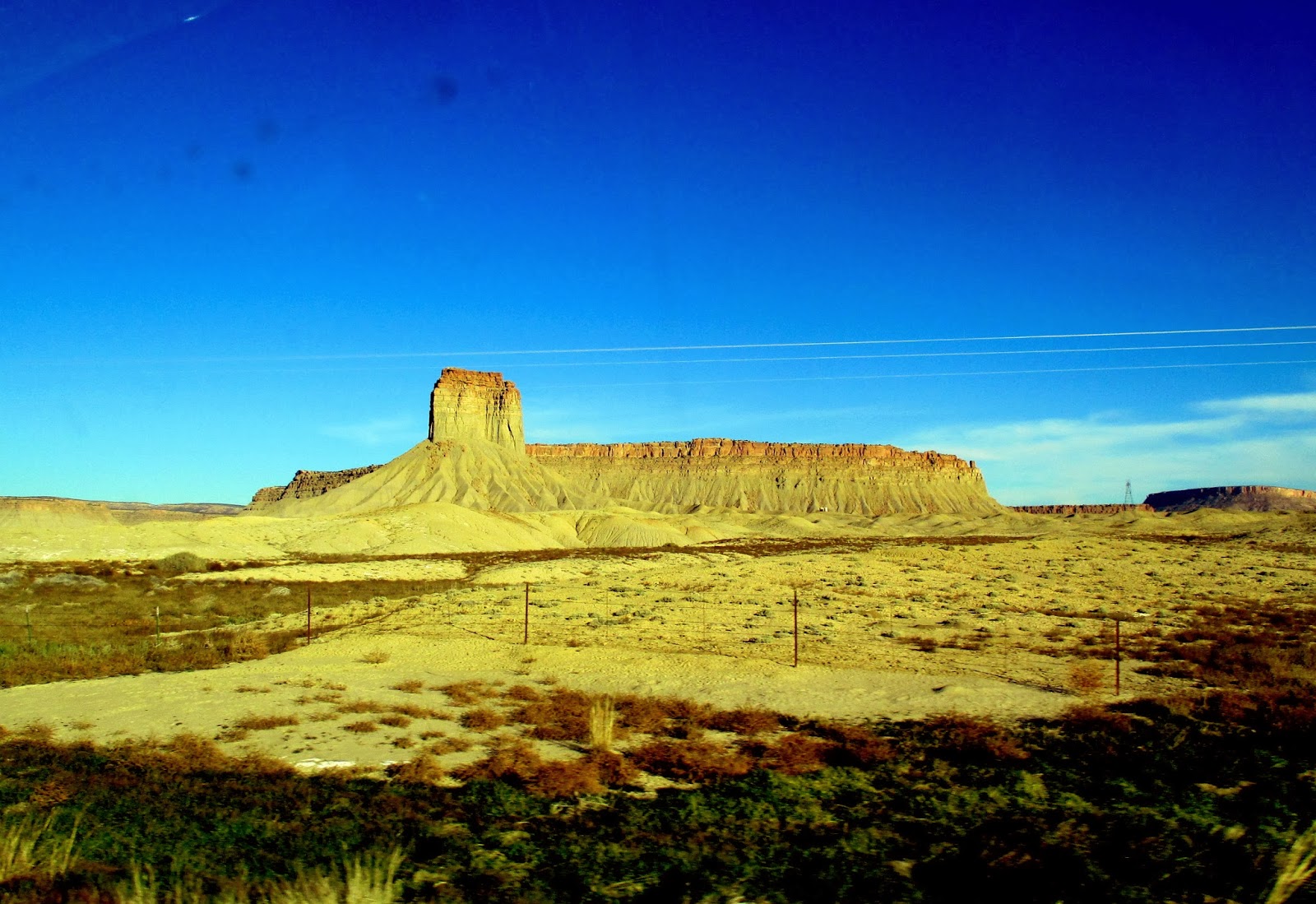
| Rock formations south of Cortez |
 |
| Church Rock |
Into
Cortez by 4, gas up, and then I drive to Monticello as the sun begins to set
behind the mountain. We always enjoy
this region of Colorado and Utah. It is
high plains country, covered with agriculture and farms. Beautiful scenery as you can see the
snowcapped mountains of the San Juans in the distance. We saw snow along the road under the bushes
on the shady side of the highway. Snow
on the mountains. So pretty.
Rick
takes us into Moab as the skies darken.
The highway is busy and the lights always bother me on two lane
roads. I wish we could have been
traveling this section about an hour earlier with the golden colors of sunset
on the cliffs and red rocks. (Can’t
complain – I was the one who wanted to stay for church and leave
afterwards!) But we could see FEEL the
rock presence and see the darkened colors and shapes for most of the way into
Moab.
Once
in Moab….uh oh!! The two campgrounds I
had planned on were both closed for the season.
I should have called because their web sites didn’t say anything about
that! We went to MacDonalds to use the
wifi, and I finally found a campground list that indicated who was open year
round. We found Slick Rock Campground just
north of town. Hurray! And the site was only $25 for the night! By the time we found the campground it was 6:30,
but we HAD arrived in Moab at 6!! All set
up in the dark and finally get a bite to eat and relax!!! Tomorrow?
Idaho!!!
MONDAY, November 11, 2013
Moab, UT to Jerome, ID
495 miles
 |
| Today's route |
Wow! What a GREAT day! We managed to stay warm enough last night,
although the trailer registered 38 degrees when I got up this morning! I borrowed Rick’s heavy socks during the
night and that kept my feet warm! We
watched the sun hit the red rocks of Moab as we showered and packed up this morning,
hitting the road shortly after 8am. Our
goal is to hit Salt Lake City right around noon. I told Rick I would drive the Salt Lake
Hundred miles today, if he would drive the first part so I could take some
pictures!
 |
| Red rock formations near Moab |
 |
| Enroute to Price |
With
the every changing vistas of red rock, white rock, strata rocks, pinnacles, and
canyons, we head north from Moab, through Green River, and up Highway 6 toward
Price. I snapped away with the camera in
the crystal clear skies and bright sunlight.
Shortly before we arrived in Price, Rick made a comment about a road
that took off to the north, remembering a route he wanted to take ‘sometime’ to
the town Duchesne. I checked the map,
did some quick figuring, and announced it would only add 50 miles to our drive,
and circle us around the backside of SLC, coming back to I-15 at Ogden. My heart started beating faster in
anticipation of ‘ADVENTURE’, not to mention avoiding most of SLC! We filled up with gas in Wellington and said,
“Let’s do it today!”
 |
| Coal plant |
As we
drove through the MIDDLE of a coal power plant north of Helper, we took Hwy 191
north toward Duchesne, UT. The route is
marked scenic on the map and we were NOT disappointed! First narrow rock cliffs and canyons, then
more open valleys and forest. Many of
the trees were dead – pine beetle? We
went over a high pass at 9114’!! The
view on the far side was expansive! And
we found snow!! Near the pass on both
sides of the road, but mostly on the north side of the cliffs and
mountains. Nothing we needed to worry
about driving. Red willows lined the
stream beds, but mostly everything was shades of brown with patches of green
trees. As we wound down a never-ending
valley toward Duchesne, we passed oil well after oil well, in one place marked
with multiple trucks of water. Were they
fracking? Nearing Duchesne we could see
the snowcapped peaks of the Uinta Wilderness to the north, with the 13,500’ highest point in Utah.
 |
Canyon walls of US 191
near Helper |
 |
| Vistas from summit |
We gas
up in Duchesne and turn west on Hwy 40 toward Heber City. Another pass (Daniels Pass at 7995’) between
here and there, as well as several reservoirs, including massive Strawberry
Reservoir near the pass. Mostly we pass
aspen groves, lining the tops of the ridges, tucked in narrow canyons. It is a shorter variety of aspen, but the
hills are covered with the white branches of the now-barren trees. How glorious this must have been a month ago
in the fall color season!
 |
| Strawberry Reservoir |
 |
| Backside of Wasatch Mts |
 |
| Lunch spot in Heber City |
We stop
at a roadside parking area outside Heber City to grab a bite to eat. The snowcapped peaks of the Wasatch Mountains
surround us. I comment they look barren
to me – brown hills with snow on top.
With the binocs we realize the dark shadows are copses of firs or pines,
and the whitish patches, which are extensive, are now barren aspen groves. Wow.
I
begin driving in Heber City and wind up the steep pass out of the valley north
toward Park City and eventually I-80 eastbound.
This connects us with the start of I-84 west and about 35 miles to
Ogden. It is not the straightest stretch
of interstate in the world! There are
sections of multiple 45 mph curves. We
pass several more reservoirs, some fairly empty, and witness the wealth of Park
City and the ski culture of the Wasatch Mountains.
I am
driving through Brigham City around 2:30p, only 1 hour later than we
anticipated if we had held to our original course….just about the 50 miles
extra (and two more high passes!) I set
the cruise control to about 70mph (the speed limit is 80 here!) and we rolled
up the road toward the Idaho border.
Quick stop in Tremonton for gas and restroom. I drive us into Idaho. Rick has called ahead to the Jerome KOA to be
sure we can get a spot there and we stop in Declo only long enough to switch
drivers again.
Arrival
at 5pm at Jerome KOA to the glory of the setting sun! We have a 10% coupon to use at a KOA, so that
makes it a cheaper night! Just 245 miles
tomorrow into Baker City – all freeway.
We considered driving it in tonight, but 750 miles is a LONG DAY for us
old folks!! (Although Rick did just comment that the 500 miles didn’t seem so
far since we had adventure along the way!)
 |
| Sunset in Jerome, Idaho |
So….tucked
into our cozy trailer tonight for one final sleep. This has been an awesome trip. So many glorious sights and natural
wonders. The fall colors were beyond my
expectations. We have renewed
relationships with family and friends all along the way. And while not as much as we would have hoped,
we have spent a few days in honest labor to benefit others. We both realize that it important to us. We feel a little guilty as we travel and it
is all self-centered. Back to daily life of multiple demands and
responsibilities. Back to immerse
ourselves in the everyday happenings of the Baker City community and First
Presby church. Back to time spent with
Luke and Kady and family! Hopefully we
will again bring something to share from our travels for others. G’night!
Tuesday, November 12, 2013
Jerome to Baker City, OR
248 miles
On our way shortly by 8:30 after gas and coffee at the Flying J. I take the wheel for the final push into Oregon! Smooth morning driving, past Mountain Home, and into Boise. We are puzzled by the thick smoke/smog/fog/dust? in the air in the Boise basin. You can't really see the mountains very well. Clouds started building the more we headed west, but this seemed lower than that.
 |
| Truly a welcome sign! |
I pulled over in Nampa for a quick driver change and drink. Rick drove us home, arriving at 11:25 Pacific Time. (You gotta love the hours you gain driving west!) Truck and trailer all unpacked by 2!!!
 |
| Snake River |
 |
| It was hazy cloudy, but still the Elkhorns welcomed us home to our valley 'neath the snow. |
TOTAL TRIP MILEAGE: 8940 miles
TOTAL TRAILER MILEAGE: 7784
Total nights: 65
Nights in trailer: 42
Total average cost per day of trip: $75.66


