Sunday, September 9-Monday, September 10:
CONTINENTAL DIVIDE TRAIL TO ALBERT PEAK
Click HERE for today's pictures
 |
| Through the trees |
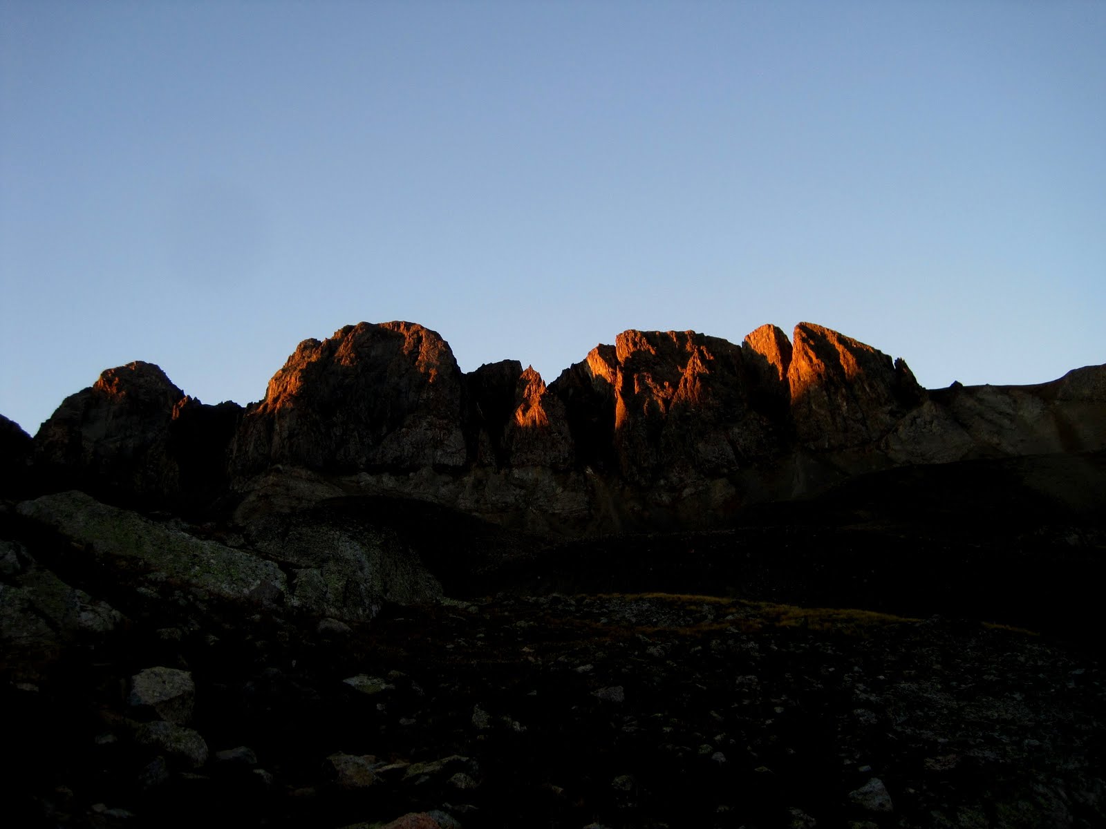
We decided to attend worship on top of a peak today since the morning dawned crystal clear, sunny, and cold!! A final hike around Pagosa Springs! Our destination will be Albert Peak, about a 5.5 mile round trip climb south on the Continental Divide Trail from Wolf Creek Pass. When we get up to the pass, there is still frost on all the meadow plants that are in the shade. It was COLD last night! A beautiful morning!
The trail climbs at a nice steady, with switchbacks, pace through the spruce forest. Many of the spruce here at the pass are dead due to bug kill, but because the lower vegetation is still so rich, green, and thick, you didn't get the sense of hiking just through dead trees. Wildflowers, except for the arnica, are largely past. The seed heads of one type of aster form white masses in many places. We did find some Jacob's Ladder blooming, and a few stands of aspen daisies. Mostly I reveled in the sunshine filtering through the trees and the woodpeckers! We had a constant music of noisy woodpeckers out getting their breakfast! Dead spruce are good for something!
 |
| Rock flow across to Lobo Overlook and north section of CDT |
Trail then opens out to the southwest ridge above a huge rock 'flow' - it looked volcanic in nature, but long, long ago. The rocks are now covered with green lichens which can the whole hillside a greenish cast. We climbed up above the flow, and came to the top of the Wolf Creek Ski Area - for the next 3/4 mile, the huts of the ski lifts were just over the summit ridge. Our views to the west were of Treasure Mountain and south toward Square Top in the distance.
Along a willow lined cliff above a huge meadow (I spied a couple of deer down in the meadow), and then up and on to the ridge itself, marked by trailposts! Old ski equipment up on top and huge log fences built long, long ago judging from the condition of the logs! At one point the ridge was narrow enough that I could stand right on the trail and take a picture east to the Rio Grande drainage and then turn and take one west to the San Juan/Colorado River drainage. Right on the divide!
 |
| CDT above ski area. Albert Peak on left. |
The trail continues around the southwest flank of Albert Peak, but we climbed up the additional 150-200' to the rocky summit. Had to boulder hop the last part of the climb and we left our hiking poles enroute. They were in the way! We stayed up on top for nearly an hour - panning the skies and the terrain with the binocs. We could pick out many of the places we have visited and hiked to during our month here in Pagosa Springs. It was a nice way to say 'goodbye' and thank you! We picked out the Pagosa Lakes area, found the townsite, the ridge of Chimney rocks, the road to Chama, Square Top, the canyons and valleys of East Fork were right below us, the CDT on the north side of the pass clearly visible. We could see the snow tunnel of the highway and I hummed the Wolf Creek Pass country-western song Gretchen told us about! Down past the peak, right on the CDT was a small cabin we think was probably connected with the ski area. And then the trail disappeared into a mass of peaks to the south!
 |
| Westward, Ginger and Inuksuk |
I built a good looking Inuksuk up on top. Never have I had a more plentiful supply of building materials from which to choose my rocks! There were two other rock cairns on top, but Inuk stood tall!
Around 12:15ish we started back down. No threat of thunderstorms today - the skies are simply filled with big puffy clouds in all directions. We met a single man planning to lunch on top of the peak enroute down, plus a couple other hikers when we hit the forest area. One couple was turning around because the altitude was bothering the gal. They had just arrived from Boston - no time to acclimate! Rick stopped just before the meadow to find a shady spot to call his mom. Since my phone was in the car, I went on and called Mom with one foot on the west and one foot one the east in the shade of the divide interpretation sign on the pass. That worked until a bunch of cars drove up, families got out, and it became grand central station!
 |
| Rick and Ginger on top of Albert Peak |
We have enjoyed Pagosa Springs immensely. It is a small town, with small town flavor. Evening we spent out at Patty's house watching the Denver Bronco-Steelers football game. We commented as we drove back through downtown on a Sunday evening - NO CARS on Main Street at all at 9:30pm - that it was alot like Baker City! I have only seen ONE mosquito the whole time we were here, BUT there are small black flies that bite. I appear to be sensitive to them and my ankles have been a mess most of the time. They swell up and react quite violently even with Sting-Eeze. I have chosen to do more of my computer work inside the trailer looking out the windows in the evenings rather than outside because of the flies.
Monday will be a packing up day. Laundry, fill the propane tank, clean things up in the trailer, and we will be ready to pull out for Ghost Ranch Tuesday morning well rested.
 |
| Inuksuk on top of Albert Peak with Treasure Mountain and western vistas |
Saturday, September 8:
PAGOSA SPRINGS COLORFEST!
THRIVENT/HABITAT WORK DAY
Click HERE for today's pictures
 |
| Balloons! |
 |
| Parrot Balloon! |
A full day today! We got up early and headed into town to catch the 8am Balloon launch as part of the Colorfest Festival this weekend. We weren't sure if it was going to "go", however, because the weather was very overcast. (It had rained much of the night out at the RV park 5 miles east of town!) As it turned out, 8 balloons went up that we saw, with two of those hovering very low and going down in the trees along the river! The rest soared up to the west and landed out by the Pagosa Lakes area. Some filled with hot air, but never took off. It started raining at the end, which may have influenced some of the pilots. It was fun to watch regardless! I was berating one balloon for being a plain green color, until I went around to look at the other side - it was a parrot!! Awesome!
 |
| The volunteers for today! |
 |
| Good looking garage! |
We checked with Patty to make sure the Habitat/Thrivent Paint Day was still happening. She hadn't had ANY rain out at her place west of town! We arrived there around 10, much to the glee of the group. Thrivent had exactly ONE volunteer there, Paul from outside Denver. Cindy, Patty & Christopher her son, Steve, the main Habitat Construction supervisor rounded out the 5 volunteers. So they were glad to see Rick and I arrive! Rick applied stain on the upper reaches of the garage all day. I painted....more red paint! Same color I finished with two weeks ago! The garage doors are all red and they ended up looking GOOD! We trimmed the windows, doors, etc. of the pumphouse/shed. Ran out of stain around 2pm, but the worst of the wood had been treated.
 |
| Check out the flame! |
 |
Look what I found
in Patty's yard! |
Cindy and a friend had provided lunch for us - another great Pagosa Habitat meal! It was really nice to make one last contact with these wonderful folks. In a banter of 'trash talk' we got invited to watch the Steeler-Bronco game with Patty and Christopher tomorrow night! Rick accepted - we don't get TV coverage out at the RV park!
We left Patty's house around 2:30 to head back to shower and clean up for the evening's events. Caught up on a few housekeeping items and at 5 we drove back in for the Band and Beers fest. Five dollars each got us into the tent, where we could get a glass of wine, etc. We enjoyed it all, including the little 84 year old lady, born in Pagosa, who visited with me frequently as we listened to the band. She was quite a character!
 |
| The field with the two balloons. |
Just after sunset, two of the balloons returned to the field right next to the big tent. They filled and remained tethered to the ground. Over the course of the next half hour or more, they lit up the interior of the balloon with the gas flame for the 'glow'. They seemed to alternate most of the time, so you couldn't get a picture with both at once. It was still pretty awesome to watch.
Back out to the RV park, in the dark for the first time. We discovered how many businesses in Pagosa have 'seasonal lights' out all year round! Pretty cool!
Friday, September 7:
DISC GOLF ON RESERVOIR HILL!
 |
Golf Course is well
marked and labeled. |
OK, so today doesn't look that exciting compared to all the other posts! We spent a lazy morning, but quality, as we Skyped with Luke for nearly an hour and a half! A good visit. Time spent reading, sorting through materials, etc. After lunch we headed into town, as we had received an email from Cindy that our mail had arrived. Picked it up, did a little birthday shopping downtown, and then realized if I wanted Kady's package mailed before Monday, it had to be today. Unfortunately the card and the address were back at the trailer. So we drove back to Elk Meadows, picked up the necessary items, and then to the post office, where I assembled it all and got the package in the mail!
 |
Getting the frisbee down
from the tree! |
 |
| Rick tees off on #2 |
 |
| Ginger lets loose on the 17th |
Then we headed over to the road up Reservoir Hill. We weren't sure if we could drive up, but the gate was open, so we did! We found the Frisbee Golf Course and had just started (on Hole #4) when a city truck stopped and asked if that was our truck parked down the road. He informed us the gate would be locked very soon! So Rick drove down the hill, parked outside the gate and walked back up. It started raining in the meantime (very light rain with a few thunder boomers). But we played the full 18 holes! It is a great course up in the Ponderosa pines - open under the trees, but plenty of obstacles to make life interesting! The holes are long enough to be challenging. Rick used the poorer of the two frisbees - that was his handicap. As it was, I don't think he kept score. I shot a 99!! All I wanted to do was break a 100 and I made it! The city has big plans for Reservoir Hill, but for now it is used to hold special events that involve camping, and it is laced with hiking and mountain biking trails. Neat area!
 |
| Hot springs 'mountain" |
Back to the trailer for lasagna dinner (love those little frozen jobs you can heat in the microwave!), salad, and bread. It is cooling down nights as soon as the sun goes down. In fact, Rick read that temps will be freezing or below by our last night here! Brrr! Fall is in the air!
 |
| Hot springs area from across river |
We did stop today while downtown to take a few pictures of the mineral hot springs that builds a little 'mountain' right in the main parking lot by the river. Also a good view across the river to the big hot springs complex.
In bed early as tomorrow is the balloon festival!! (Plus we are going to do a little more Habitat work as they are short of volunteers!)
 |
| Pagosa Peak in the distance as we walk down Reservoir Hill |
Thursday, September 6:
CHIMNEY ROCK ARCHAEOLOGICAL AREA
Click HERE for pictures from today
 |
| Chimney Rock peaks as you enter the site. |
Our main adventure today was a visit to Chimney Rock Archaeological Area west of Pagosa about 20 miles. This is the northernmost outpost of the Chacaon Pueblo Indians, more typically known as the Anasazi (think Mesa Verde, Bandelier, etc.) It is regarded as one of the astronomy/spiritual outposts as well, as the two rocks lined up during a lunar standstill for the moon to rise between them. The area is seeking National Monument status, but currently is under the supervision of the Forest Service and a crew of 100 volunteers. Terry Pickett and his wife Johnnie both volunteer.
We arrive at 9:15, just in time for the 9:30 tour. You can go on a self guided tour, but it doesn't include the upper mesa, and it still costs $10 each. So you might as well take the guide! Ours was Scott who was very knowledgeable, but also talked ALOT. We ran behind schedule! We had 9 people in our group. (Mostly Texans and Coloradoans, plus Rick and I!)
 |
| I got to grind a little corn! |
Your caravan in your cars and additional 2.5 miles from the entrance cabin to the top of the mesa, climbing about 1000 feet. We parked and Scott led us around the 'residential' section of the mesa - pits from former houses, talking about the agriculture, why the people came up to the heights rather than stay down in the valley, etc. Interesting, but I was anxious to get up to the upper section!
 |
| Rooms of Great Kiva up on top of mesa |
Finally, we start up the trail to the upper Great Kiva, a spread of about 30 plus rooms on the very top at the base of the Chimneys. There is some fascinating information about how various parts of the mesas line up geometrically, as well as a method of signaling from Chimney Rock clear down to Chaco Canyon Pueblo 90 miles away in New Mexico. It was hot in the sun, even though early in the day, but fortunately for the most part some clouds came in that blocked the worst of it. We also saw a couple of little lizards, and fortunately, NO rattlesnakes, etc.!
 |
| Chimney Rock from mesa with rabbitbrush |
Down around 12:30, talked for abit with one couple from the tour - he had attended New Mexico Tech. He was on oxygen and did a great job getting to the top and back down! Then a quick run into the gift shop to pick up a new hat for Ging, and back to Pagosa to make our 1pm appointment with Piedra automotive for an oil change, tire rotation, etc.
While the car was being worked on, Rick and I caught a ride down to 160 and the Sourdough Pizza place on the corner. We were the ONLY ones in the restaurant, so could switch channels on the big screen TV to tennis. We sat and watched and enjoyed a wholewheat sourdough thin crust grilled chicken pizza with sun dried tomatoes, bbq sauce, and artichoke hearts! Yum!
 |
| Little church in Pagosa Springs |
We walked back to the auto place, picked up the truck, down to a car wash, back up to grocery shop and gas up using our City Market 10 cents off, a picture of the little church I wanted, and back out to the trailer park. A full day (and spendy one!) We stopped at Habitat to see if the mail had come, but no one was there. :(
Quiet evening at the park watching a little tennis on the computer.
Wednesday, September 5:
Nothing much to say for today. We relaxed, we rested, we had dinner with Terry and Johnnie Pickett at Bear Creek Grill, returning all the maps they loaned us. Great people. Rest of day spent getting caught up from Monday and Tuesday! See below!
Monday, September 3 - Tuesday, Sept. 4:
CLIMBING HANDIES PEAK, A 14ER!!
Click HERE for pictures of our adventure!
 |
| Upper Rio Grande valley north of Creede. |
So, whatever I wrote down below for Monday only applied until about 10:30 am, when I looked at the weather forecasts and commented to Rick that Tuesday looked to be a better day for climbing than Wednesday. Our lazy morning then shifted rapidly into high gear as in one hour we fixed the food, packed the truck, and were off for Lake City, CO, about two hours away (north of Creede). So....no gift shopping, relaxing, or exploring downtown Pagosa!
We left around noon, drove to South Fork for drinks and some jerky, and on up the Silver Thread Scenic Road to Creede. Gas was 35 cents cheaper in Creede than Lake City, so we filled up again there to make sure we wouldn't have to buy gas at over $4 a gallon.
 |
| Slumgullion Earth flow |
Got ahold of Luke by phone leaving Creede (we had talked about Skyping today) and talked with him as we drove northwest through an incredibly beautiful upper Rio Grande valley - lush green grassland and hillsides covered with aspens turning colors. Up over Spring Creek Pass, broad plateau area with some waterfalls, and then higher again over Slumgullion Pass at 10,800. The Slumgullion Earth flow occurred about 700 years ago and blocked the Gunnison River, forming Lake San Cristobal, the second largest natural lake in Colorado (first being Grand Lake up at RMNP). Near the top of the pass is Windy Pass Overlook which we stopped at in the midst of a rain cloud! We couldn't see much of anything, especially not the Uncompahgre Mts. to the north!
 |
Power of the internet!
Pioneer Presby in Lake City |
 |
| Alpine Loop valley and mts. |
We dropped down into Lake City, a mining town which blossomed to nearly 10,000 around 1870. Its year round population is now around 400, but it does have a Presbyterian Church - the first built on the western slopes of the divide! I wanted to get a picture of the ornate steeple added in 1890 or so, but as it ended up we didn't return to town. We checked out the town as we drove through - a typical small town, nothing overly exciting. We stopped at the visitor center at the far end of town and asked some questions about the road up to American Basin, etc. plus picked up some information and materials. Tried to get some pizza at one place, but we were going to have to wait over 30 minutes to get served. We decided it was time to hit the road before it got any later! So, around 4:00 we start up the Southern portion of the Alpine Loop, past Lake San Cristobal, and up. The first 12-14 miles were smooth going, past high ridges covered with aspen trees, the Lake Fork of the Gunnison River meandering up the valley. We stopped to fill all our water bottles and get another drink of water at one of the campgrounds - we knew it was going to be 'dry camping' tonight at the trailhead. In one of the beaver filled ponds, Rick suddenly stopped - a cow moose was eating the reeds in the pond. We watched for some time as she nuzzled her big head down into the water to pull up a mouthful.
 |
| Big cow moose in pond. |
 |
| Truck parked at upper trailhead, American Basin. |
At Sherman, the road turned uglier as it wound up the sheer rock canyon above the Lake Fork, through more aspens, but narrow. Fortunately at least, there were turnouts frequently as we encountered considerable 4W traffic and jeeps coming back in from a day of exploring. Three miles beyond Sherman, we came to Burrows Camp - the last restroom on the road! It is also a common staging area for 14er ascents of Handies Peak (through Grizzly Gulch) and Redcloud and Sunshine Mountains on the north side of the road. We stopped to eat some dinner, as we didn't want alot of dinner smells lingering in the truck - this is bear country and signs posted to remind us! Burrows was busy with many cars and campers. Beyond Burrows, an ugly road got uglier, if at all possible! We continued to climb as we rounded Whitecross Mountain (so named because of white cross of quartz on the summit - we never could see it.) Three more miles to the junction with the American Basin 'road'. We had to ford the creek - Rick got out an checked it out first due to some major rocks. He continued on and after a particularly sharp rocky stretch, said, 'this is it'. But....no flat spot to pull over and sleep halfway level, so we went on....eventually to the upper trailhead. We pulled into the ONLY level spot - rather on a knoll above the creek. One other car in the turnaround with a figure just waiting...we eventually found out why when hikers came down the trail and he was their ride out.
 |
| American Basin, San Juan Mountains |
American Basin is everything I had heard and read it to be. I can only imagine what it must be like in the midst of summer when the wildflowers will literally carpet the basin. Now in early September, everything is past - although we did find three small flowers during our hike: a tiny yellow cinquefoil type, a little oxeye white daisy (half inch wide?) and some quarter inch wide purple moss campion flowers. The headwall of the basin is formed by 13,200' to 13,800' peaks of jagged and crumbling rock. The talus slopes were huge. One interesting formation that we got a better look at during the climb was a rock glacier - a glacier completely covered by talus rocks. You can see the morraines on each side and the terminal at the foot. There was no sign of any glacier except for the wonderfully full creek which flowed out from the bottom! From above, the rock glacier looked like a giant brown tongue.
Rick and I had already eaten, so we spent the remaining daylight making sure all of our packs and gear was ready for the early morning departure. Rick fixed up his sleeping bag with his exercise pad in the truck bed, covered it all with a tarp to ward off the dew and wind. I made my 'bed' in the backseat of the truck. We took a short stroll along the creek, visiting with a Wyoming couple who arrived to climb the peak also in the morning. Right after we arrived, a black truck pulled in, two hikers and a dog got out, and left for the summit. It was 6:15 in the evening. I figured they were going up to camp at Sloan Lake, but another group said they thought they were climbing to the top. (Sure enough, shortly before 9pm, we saw two bright lights and a red light (the dog) come bouncing down the trail. They then camped in their truck for the night.)
 |
| Sunset! |
Remaining daylight spent reading. The sun setting on the peaks was awesome, and at sunset Rick looked up to the western ridge above us and pointed. A bull elk was silhouetted in the western sky. Too far for a decent picture, but in the binocs he looked majestic! Another elk joined him while we watched. Good wildlife sightings for today - we just haven't seen a bear, but tonight isn't the night we are hoping for that excitement!
We crawled into our sleeping bags around 8:30pm! Alarms set for 5am, hoping for a pre-6am departure in the morning. The stars are glorious. The moon will rise later. The sounds of the creek lull us to sleep.
It is a restless night for me. I probably wake up every 45 minutes at best to check my watch, see what is happening outside, look at the stars and the moon, and anticipate our climb! Not to mention I was just a little too long for the Honda across wise (but definitely better off than Rick would have been!) We both rise during the night (nature calls!) and the air is brisk, the stars incredible, and the moon is lighting up the whole basin. I can't imagine how bright it would have been were it a full moon.
Finally...it is 5am. It is cold! So glad Rick had winter bag in the truck for October! Gloves, headbands, etc. and two jackets! I felt like Luke wearing all of Jed's clothing when he came unprepared for a trip. Rick took care of me. When I arose, Venus was peeking through a rock formation, the belt of Orion was pointing right down to the peak, and the moon like a nightlight. We grabbed our breakfast, and by 5:55 were ready to 'hit the trail', flashlights ready, but we never used them. The light of the moon on the gray rock trail was all we needed.
 |
Too dark for photographs, so I'll include
my scribble for today! |
The trail up to the main American basin was slightly magical in the moonlight. Rick and I stopped briefly to say a prayer together, for strength, breath, insight, and to see God's majesty. It felt good to do so. We each had one of the hiking poles the boys gave Rick, and Rick carried about a half gallon of water which we planned to ditch when it was empty and pick up enroute back down. We also planned to ditch our heavy jackets shortly as we warmed up!
 |
| First light hits the headwall. |
I thought I might be able to get a picture of the moon as it set in the peaks, but as we climbed, the moon seemed to sit still. I finally told Rick, "We are climbing faster than the moon is setting!" Actually we were just getting higher in the basin, so the perspective kept changing. But I liked to think that we were moving faster than the moon! The sun didn't 'rise' until we hit the saddle, at about the 13,400' level. It was due east of Handies and 14,000' is a high mountain to get the sun over!
We passed several streams flowing out of the rock glacier and Sloan Lake - tiny waterfalls and cascades. In one place along the talus slope, we could hear water gurgling beneath the rocks, but no stream was visible. That was rather eerie - maybe it was another glacier type thing. Sloan Lake sits right below the headwall - you can hike right past it and never see it when traveling uphill. There are a few flat spots to put a tent, but Rick and I both agreed it is NOT a place we would want to be camping in a thunderstorm!
As we arrived at the saddle above American Basin (and the sunshine!), we were suddenly blasted with an icy wind. We thought it would be with us to the top, and were surprised (when we finally made the summit) to find the peak itself was calm. I was able to strip clear down to just my two t-shirts for a good tie-dye picture. (Naturally I had planned my outfit so I could have a tiedye summit shot!)
 |
| On top of Handies Peak! |
The last 600 feet up along the ridge were steep, on a trail often gravely and slick. I wondered going up what the going down was going to be like. (Not as bad as I feared....we went into the looser rock off to the side of the trail for better footing.) After a series a short little snake-like switchbacks, I told Rick, "I think we are nearing the top!" His reply, "Honey, we are there!" Hurray!!! We arrived at 8:40, about 2 hours and 45 minutes of hiking time. I was pleased as secretly my goal had been to make the top by 9am, or three hours.
OMG to use Facebook terms! What a view! The mountains to the east were a little harder to see in the morning sun, but to the west, north, and south, nothing but peaks. Especially to the west, in the heart of the mining country, we saw reds and whites. Nothing has snow on it this time of year, but plenty of gray and white rock. As we saw two hikers approaching from the Grizzly Gulch trail shortly after we arrived, I quickly took my panorama 360 shot from the top. (So far I'm having trouble with Hug-in at stitching it together, so it may not appear in the blog yet.)
 |
| View north from summit toward Wetterhorn and Uncompahgre |
 |
My inuk isn't very clear here, but
the view is awesome! |
 |
| Rick with Sloan Lake & American Basin headwall. |
The young couple arrive having left from Burrows camp at 6am also - we laughed and said youth got them to the top in the same amount of time it took us to climb from about 800' higher a start and at least a mile shorter trail! We took their picture and they took ours. I built an inuksuk. They drank a celebratory beer! Rick and I ate our very cold and firm Clif Bars. There were clouds in the distance to the west, but otherwise it was amazingly gorgeous on top of the peak. We stayed for 45 minutes when, with the clouds suddenly amassing quickly, we started back down.
We had expected the other couple at the trailhead to pass us at some point on the ascent. But instead, we met a threesome from the United Kingdom on the ridge going down, then another couple celebrating their 42nd anniversary, and finally....2/3 of the way down, the couple from Wyoming. They had slept in! I hope they made it!
By the time we picked up the water jug, then our coats, and had shed some of what we were wearing, I felt like we appeared to be walking clothing stores by the time we arrived back at the truck. I had my windbreaker slipped through the loop on the pole, the jacket fastened into my fanny pack, and the polar fleece around my waist. Rick was carrying two jackets with him. Going down took as much time as going up (well, nearly!) because I had to stop to take all the pictures that were in the dark going up! We also stopped to briefly explore Sloan Lake.
 |
| Coming down, alpine terrain. |
Arrived back at the truck at 11:30 - 5 1/2 hours total time to summit and back. I felt pretty good about our efforts and our planning! A quick bite to eat and 15 minutes later we were heading back down the 'still ugly' road! (It hadn't improved over night!) I knew Rick wanted to get this part of the drive out of the way and he had promised the Honda the night before, "No more!" When I visit American Basin in the summer wildflower season, we will spend the money to rent a jeep for the day! Our Honda needs to pull the trailer, we can't abuse it like this! But we made it down, while discussing our plans for the rest of the day. We decided that if we weren't going to explore the northern Alpine road, there wasn't much point in staying in Lake City. I suggested we just head to Creede for a meal and then head home. We had to stop in Creede anyway, because I had seen a deck of cards with the 53 14ers of Colorado and Rick had promised to buy them for me if we made it to the top. I was holding him to that promise! (I didn't hold him to a picture of the Presby church steeple - I'll get it off the internet!)
So...Rick drove to Creede and we each had a huge 'wrap' at the Old Firehouse Pub and Hotel. Bought my cards and I drove home to Pagosa! The folks at the RV park wondered why we were back so early, as we had told them we were leaving on Tuesday, not returning!
What a great adventure!! The climb, the night out, the beauty, the accomplishment. We are feeling good! Retirement is wonderful! God is good! All the time! Amen!
 |
| From Windy Pass: Wetterhorn, Matterhorn, Uncompahgre, and Crystal Mountains - all north of Lake City. |
Sunday, September 2 - Monday, September 3:
LAZY REST DAYS!!
 |
| Rick took these pictures! |
 |
| Glorious skies! |
Literally, we did very little this two days. Church on Sunday after a beautifully relaxing morning in the sunshine at the park, then some phone calls to Moms and Jed, grocery shopping for the week's adventure, and reading, writing, and watching a little US Open tennis. Highlight of the day (and the only pictures!) was the sunset over the western sky!
Monday we spent another lazy morning, heading in to town in the afternoon to do a little souvenir shopping and exploring downtown. Then prep time for our trip, leaving in the morning for Lake City and the Alpine Loop.
Saturday, September 1:
BLANCO BASIN ROAD AND OPAL LAKE HIKE
Click HERE for today's pictures
A bit lazier day today after yesterday's driving! For the first time we headed SOUTH on Hwy 84 toward New Mexico! (We only went 8 miles, but it was south!) More ranch land, barns, and grasslands in between pine and aspen covered ridges.
 |
| Square Top Mountain |
 |
| Classic barns! |
We drove about 10 miles up the Blanco Basin Road, then 3 plus miles on Forest Road 660 to the Opal Trailhead road for the final mile to the trail! Whew! It wasn't that hard to find! The trail continues past Opal Lake, but judging from the conditions of the route beyond the lake, I believe 90% of its use is for the 1.2 miles to Opal Lake. Enroute we circled at the base of Square Top Mountain, which to me looked more like a muffin or mushroom!
 |
| Opal Lake |
The lake got its name from the minerals that are located near the inlet - and the creek above. We heard from others than it used to be a milky turquoise, but low water levels have increased the algae and it is now a milky green! High rock cliffs above the lake - Flattop Mt. and V Mountain - are my best guesses from the map!
 |
Rick looks so small compared to these
giant aspens! |
Fairly easy mile plus into the lake, climbing about 600 feet. A well graded trail, with level stretches interspersed with steeper uphill. Meadows, and thick groves of aspen trees. There is a band of aspens above the lake that would make for spectacular photographs in about two weeks. The trees here are perhaps a bit lighter shade of green, but the colors haven't started for the most part.
Beyond Opal Lake the guide indicates a good chance of seeing Blue Columbine. I looked all around the lake, but alas...no such luck. We are getting a little late to hope to find one blooming in its natural setting. Rick did see several gentians, however, and Rick found an Oregon grape plant, which I didn't know grew in Colorado! Otherwise, an abundance of aspen daisies (I now have the official name of the purple aster type flowers growing in the aspen groves!), geranium leaves changing colors, harebells, yarrow, and some pearly everlasting. I circled the lake to try and identify a large pinkish plume that we saw from afar, only to get lost in the willow thicket and give up! Then we saw another in a more reachable location. I still need to identify it.
 |
| Any ideas? |
 |
| We found a few orangish aspen leaves! |
We met several others up at the lake - two groups from Albuquerque, another from New Hampshire, and another with 6 dogs that we NOT as well behaved as Marg's menagerie! One of the little dachshunds peed on my camera pack while I was on the other side of the lake! That went in the wash this afternoon! We arrived back at the truck at 2 pm - it seems to be our normal 'end of hike' time! Rick decided he had driven enough over the past week, and I drive us back to Pagosa, where we gassed up, called Terry Pickett about his maps, and went back out to the RV Park.
Quiet evening enjoying the two little boys next door with their family, BBQ steaks (Rick is ready to throw our new BBQ mini grill in the trash, however, as he had to relight it 15 times to cook the steaks!), corn, and a big salad. Clouds are gathering, but no big storm today. Instead it was to reach 88 degrees in town! We put up the awning and ate dinner in the shade of the trailer on the opposite side.
Friday, August 31:
DRIVING TRIP TO THE MINING TOWN OF CREEDE, COLORADO
Click HERE for today's pictures
 |
| Our route to Creede |
 |
| Enroute to South Fork |
We did a little more extensive driving today - about 137 miles total in driving over Wolf Creek Pass to South Fork, and then up to the mining town of Creede, Colorado. This was the first time we have traveled beyond the ski area up on Wolf Creek Pass. The road drops down into a rock cliff lined canyon, through one snow shed tunnel and another complete tunnel.
We are a little disappointed in South Fork. It was much more open valley than we expected, spread out, and really didn't have much of a downtown. Many expensive homes are being built along the Rio Grande River north of town on Hwy 149 toward Creede. Creede is located 21 miles north of South Fork. It is the ONLY incorporated town in Mineral County, Colorado. This is mountain country! Between South Fork and Wagonwheel Gap we passed through some high rock cliffs. A the gap, we suddenly broke out into a huge valley, green and lush. Creede is tucked into a tight rock gap in Willow Creek Canyon where the Rio Grande takes a sharp turn to the southwest to continue towards Lake City.
 |
| Old train bridge over the Rio Grande |
 |
| Main Street, Creede |
We parked and wandered around the downtown abit, poking into a few shops, mailing my package to Liz, getting some info from the Visitor Center and Forest Service station. A tiny "art park" had some great local sculptures, most out of metal. I also finally found a blooming blue columbine in the park. I was beginning to wonder if I would be stumped, if we were too late for the columbines!
 |
| I finally found a blue columbine! |
After purchasing a few more items at the grocery store, we had a picnic lunch at the city park. Then it was time to head beyond the downtown on the Bachelor Historical Tour - 17 miles up into the high country past multiple mines, two back in operation. From the narrow canyon confines uptown, you follow Willow Creek to the junction where the two forks split off. Mines were located on both branches, but the main road now is maintained only for the West Willow Creek district. Creede is known for its silver production, and continued mining well past most of Colorado's mines. The silver was largely found in a huge vein of amethyst than ran the length of Willow Creek at an angle.
 |
| Old mining building with golden aspens! |
 |
| Aspens were changing! |
The weather turned a little sour on us, but we took the drive anyway - blue skies and sunshine would have made for great pictures, but the day was wonderful because we saw aspen trees in gold and orange high on the hillsides! Only a few drops of rain fell, and I never heard any thunder, just big dark clouds!
 |
| Amethyst Mine |
At the Amethyst Mine, one of the largest producers of silver, we found several huge building remains, and looked up the hill high above to see the Last Chance Mine located in a golden grove of aspen trees! We had to laugh as we found realty signs up on the far reaches of the loop, one even looked like a development had been started. This stretch was marked by aspen groves and classic old west wooden fences. We passed some beaver ponds and found some lodges and dams. Old cabins in various states of ruin dotted the landscape.
 |
| Main building of the Last Chance Mine |
About 11 miles into the loop we came to the road leading down to the Last Chance Mine. It advertised "restrooms". We didn't need that, but it would get some people down the miserable half mile excuse for a passable road! We were greeted by the owner of the mine, a gentleman named Jack who gave us a little history and then invited us to look around, prospect if we wanted, and enjoy the view. The mine is located on the precipice of the hillside. Jack purchased it in 1998 from the family of the original 1889 owners for the price of about $3000. He wants to restore it to a functioning mining museum, with plans to reopen the adit next year and begin re-shoring up some of the tunnels for visitors. He now lives in one restored building, with a deck sitting out at the 10,600' level with vistas over a huge valley. He rents another as a separate cabin, and also maintains a bunkhouse to sleep 4 above the little museum. He only takes donations for the rentals, as a repayment to the family for selling him the place so cheap. He makes his money from the small fee people pay for what they prospect and the cabins. It was an interesting place. We bought a slab of amethyst/sowbelly agate just in support. I'll make a trivet out of it!
 |
| Rio Grande valley and Creede in foreground. |
From the Last Chance we began to drop down in elevation, past the former town site of Bachelor, which grew when the Last Chance was producing AND Creede burned. Eventually dropped down to the hill above town and the cemetery and Sunnyside Church, which the town is trying to restore. The hill was to be the site of the Balloon Burn later at night, but we decided we really didn't want to wait around for 2 1/2 hours until that began at 7. So we headed back toward Pagosa!
Stopped at the Wagonwheel Gap, Cottonwood Camp Lodge for an ice cream cone, and home to the trailer by 6:15. We found the RV park has filled up considerably while we were gone - Labor Day visitors. A nice family with two small boys next to us - from Albuquerque. We loaned them our Hiking and Driving guide for the evening.
A good day!
Thursday, August 30:
FOURMILE FALLS HIKE
Click HERE for today's pictures
 |
| Lower Fourmile Falls |
Our adventure today was a drive up FourMile Road eight miles north of Pagosa Springs, right at the base of Pagosa Peak, and a hike up FourMile Stock Drive Trail. Rick and I have seen old signs along some of the trails referring to stock drive boundaries, etc. I finally googled it and still know nothing! Today they seem to refer to trails open to ATV's. Our guess is they are old routes used to drive cattle and sheep to upper pastures.
Anyway, we are on the trail by 8:45 or so, again hoping to beat the thunderstorms! This trail is not as critical, however, as we won't be on an exposed high elevation slope in the afternoon! The trail drops down for about the first half mile.....another trail that I will have to end with an uphill climb! The rest of the 3.5 mile hike in is on a gentle uphill through open meadows with views to Eagle Mountain and Eagle Peak No. 2 (we haven't figured out where Eagle Peak No. 1 is!), through forests carpeted with nearly spent wildflowers, berry bushes, and aspen groves (especially at the beginning).
I'm not sure I'll be able to recall all the flowers and plants we saw, but I'll try! We also saw some pretty fall colors starting to emerge, especially with the geranium, thimbleberry, and fireweed leaves.
Butter and Eggs - abundant
 |
| Butter and Eggs |
Paintbrush
 |
| Mountain Bluebells |
Mountain bluebells
Wild Geraniums - abundant
Harebells
Purple Asters - abundant
Larkspur (mostly dead)
Sunflowers
Goldenrod
Pearly Everlasting
Purple Vetch
Solomon's Seal
Fireweed
White Daisy like flowers - abundant
Phlox (by the Upper Falls)
 |
| White Daisy like flowers |
Wild Strawberries
Wild Raspberries
 |
| Wild geranium leaf in fall glory |
Thimbleberry
Elderberries
Different kind of juniper bush
Two others I need to identify!
Wildlife viewings included three more grouse, and a vole.
The lower Fourmile Falls is actually on Fall Creek. This time of year it is a misty plume of water that freefalls down to the rocks below. We walked in to the bottom of the falls on the way back and I was surprised to find no pool at the bottom. You can just imagine the whole rock face covered with mini waterfalls during the spring.
 |
| Rick & Ginger at Upper Upper Falls |
 |
| Rock formations were outstanding! |
We lost the trail for awhile near the lower falls, as we thought the main trail was just a side trip to the lower falls. Discovered our error when in crossing the creek we totally lost a trail. Backtracked and did discover a cairn at the junction. From that point, the trail often was more of a rocky creek bed climbing past the Lower Falls to climb steeply to the TOP of the Upper Falls. That was a surprise for me - we came out even with the top of the big drop. On up we did come to another cascading plunge or as I called it, the Upper Upper Falls. More water here as this falls is on the main Fourmile Creek. We explored looking for a good spot for a bite to eat and finally ended up on the trail when we could see the Upper Falls.
All the rock in this area is called breccia - it is like a gray green cement encasing rocks and boulders of all sizes. Extremely water resistant, as the falls haven't been able to wear away the surface much at all!
A hot day! Thankfully parts of the trail were in the shade and a breeze was blowing up on the trail during lunch. The sun is intense at high elevations! And the storm clouds were late in gathering today, which meant they were never a concern, nor did they provide the cooling effect!
 |
| Rick at Kip's Grill and Cantina |
Back to the car at 2pm and we drive into Pagosa to pick up stamps at the postoffice, dine at Kip's Grill and Cantina, and do a little grocery shopping. We had to go to the cantina because they had advertised a portebella/avocado sandwich! I had that and Rick a green chili smothered cheeseburger. Filling!
Lazy late afternoon and evening at the campground after showers. No storm today! Clouds, but no rain or thunder or wind!
Wednesday, August 29:
EAST FORK ROAD TO SILVER FALLS
Click HERE for today's pictures
This morning was a bit more relaxing as we didn't have to race to beat a thunderstorm! But by 10am we were ready to head out for the day. Since we can't hike 8 miles every day in a row, today will be a REST day - a short hike with a drive.
 |
| Rock formations on the left and East Fork River |
Our destination is ultimately Silver Falls on Waterfall Creek up the East Fork Road of the San Juan River. This road takes off about 7 miles east of our RV Park, passes through a huge grass field of cows, and then enters a narrow canyon, marked by 'beehive' or 'hoodoo' rock formations on the north side. The trail/road guides all indicate it is for high clearance vehicles ....and judging from the number of puddles (BIG!) and creeks we had to ford, they weren't kidding. This was originally the route of the main east/west divide pass up until a major flood in 1911. If we had a real 4W vehicle (that we weren't depending on to pull a trailer and a few other niceties) we
COULD have driven on another 25 miles or so over Elwood Pass to a town of Summitville. But I won't tell you the condition of that road! At the third major creek ford, we turned around on the road we were driving on!
 |
| Butter and Egg flowers and the mountains |
East Fork Campground was filled with reservation slips for the weekend. We were a little surprised at the $18 price tag for a fairly primitive campground - two water pumps as amenities and that's it! (Vault toilets, etc. ) All along the river hunters, campers, etc. have staked out spots.
 |
| East Fork San Juan River and the big valley. |
Our road was lined with butter and egg flowers - tall yellow spires carpeting the sides of the road and many hillsides as well. I haven't seen this many all in one area before. We also saw plenty of purple asters, white yarrow, and a scattering of red gilia. No blue columbine. :( We did see a fuzzy caterpillar on the trail, but no other wildlife (golden mantle ground squirrels don't count as they are everywhere!)
Once past the canyon, the road opens out into a breathtakingly beautiful mountain valley, carpeting with grass, the river braided in multi sections through it, and an array of high mountains as a backdrop. This is a privately owned valley, but public access on the road and into Silver Falls.
 |
At Silver Falls |
 |
| Silver Falls |
At the 8 mile point, we find the former guard station and a small parking area for Silver Falls. We hike the eighth mile or so UP a fairly primitive trail to the cascade of water, and then look up to the falls themselves: a misty, fan-shaped waterfall that divides into multiple rivers and mini-falls. Water levels are low, but it is still beautiful. We hike right up to the base of the main falls.
Leaving the falls, we drive on up the road about a mile, find where Elwood Pass Rd. cuts off, and the Quartz Meadow road continues. As it would involve another major creek crossing, and we aren't sure what we will gain by it, we turn around!

Around the 4 mile mark, we find a campsite next to the river and pull over for a tailgate picnic in the shade. A peaceful place! Rick commented as we finished up lunch, "I think I will like this retirement business!"
Back to the trailer around 2pm to relax, catch up, and ride out another afternoon thunderstorm - with high winds, a little thunder and a splattering of rain. By evening, the skies were clear enough to see a nearly full moon arise over the trees south of us.
 |
| The mountain valley near Silver Falls. |
Tuesday, August 28:
CONTINENTAL DIVIDE TO ROCK LAKE
Click HERE for today's pictures
 |
| On the Continental Divide Trail! |
Now today is what retirement should be like! (Actually the volunteering was really good too!) We got up early (again!) so we could be on the trail no later than 8:45 am - have to beat the afternoon thunderstorms. It is absolutely clear in the morning, however. Blue skies and sunshine and about 50 degrees at the campground. Felt colder up on top of Lobo Lookout, however.

We drove the 17 miles up to Wolf Creek Pass, and then up the additional 2 miles to the radio tower and the trailhead parking lot. It was cool! Everything is damp, puddles, etc. The wind storm we got yesterday afternoon produced a good rain at the top of the pass, and, as we later discovered, some hail!
We are on the trail by 8:40! When you start the hike at 11,800' at the top of a mountain, you really have nowhere to go but DOWN! And down we went, for over a mile, passing the junction where the Continental Divide Trail takes off for Wolf Creek Pass itself, and then the Weminuche Wilderness area sign. Our surprises today were the meadows - vast grasslands that span the divide in several places, and the forests. We went through a section of forest without any views at all for over a mile. The spruce forest is not healthy up here. Many dead trees, but they evidently produced many seeds as they were dying, because the little spruce trees are everywhere!
 |
Yellowing plants provide color in front of volcanic rock
formations. |
We found some flowers still blooming. Prominent were Rick's favorites: the blue gentian. These late bloomers lined the trail for much of the route. Also saw blue harebells, some paintbrush, white yarrow, heartleaf arnica (dying), white daisies, one wild geranium, Jacob's ladder, wild strawberries, and a few others I couldn't identify.
 |
| Rock Lake |
We veered off the trail at about the 2.5-3 mile mark to explore a huge grassy meadow region. We saw the trail curve around a hillside, so we knew it had to be below us, so we just went downhill until we found it again! I thought we had found Rock Lake when we came to a dried up lake bed filled with rocks, but a short distance further revealed the REAL Rock Lake, with a sign saying "Lake Joyce". Hmmm. The map definitely said Rock Lake. Who knows? A pretty little lake with striking reflections of the trees and clouds. Since it was nearly noon, we decided that would make a good final destination. We were about 4 miles in and the clouds were building up - we knew we didn't want to be up on top by the radio towers when the lightning came!
So....a quicker hike back to the top, but it was all uphill for the final 2 miles! That's the problem with starting at the top of a mountain! We started hearing thunder around 1:15, and could see where rain was falling in the distance, but we didn't get any drops until we were leaving the parking lot. Heavy rain as we dropped down off the pass.
 |
| Pagosa Springs resort |
Home to throw some salmon and a hard boiled egg in with the salad, and instant dinner! We were hungry! Then we grabbed our towels and suits and decided it was a good time to use our free passes to the Pagosa Springs Resort - the hot healing waters of the springs! I didn't take my camera into the pools, so other than the entrance building, all you'll get is my interpretive scribble! There are about 7 pools of temperatures ranging from 99 degrees to 111 degrees, plus a large swimming pool at 77 degrees and the river! The minerals in the waters have produced a tall mountain of orange colors, plus a little "volcano" in the middle of the pond. There is a bridge through the pond you can walk on to access another pool on the other side. It was nice - plenty busy as we discovered Tuesday is the locals day - they get in for $8 instead of $22! A good soak to relax some tired muscles!
 |
| Rick and I enjoy the hot mineral waters! |
We left the springs around 6:30, stopped to get an ice cream cone for dessert at the Malt Shoppe. While there we watched two buckets of 12" trout being dumped into the river - they were stocking. No wonder the fishing is good!
Tired! We plan to drive and hike tomorrow. Mostly an explore with the truck with a short hike tossed in! G'night.
Monday, August 27:
This will be another boring entry! Sorry, folks! Beautiful weather this morning! I took Rick in to the roofing house around 8:15 after we said goodbye to Peggy. While Rick worked, I stayed and drew a scribble, talked to Mom on the phone, and after checking with Rick that he would be another hour or so, I took off for the discount store and then a gift shop! Picked up a pair of flip flops for each of us for only a dollar each! I had been waiting for them to get cheap at the end of the summer - we wanted some for showering.
 |
Rick, Jimmy, and Terry work on the
roof Monday morning. |
Stops at Ace Hardware, Radio Shack, and then Subway to split a sandwich for lunch! Moderately successful in shopping, but we are accumulating a good list for Albuquerque!
A quiet afternoon. The park is only about a third full, with an occasional overnighter pulling in. We do have someone next to us again on the west side, but the two big spots to the east of us are still empty where Jimmy and Mark were parked. The wind picked up this afternoon to a degree we hadn't seen before. We put the awning back down. Finally we are getting quick at putting it up and down. It took me awhile to get the process down!
Tomorrow we are hiking!!!!
Sunday, August 26:
Our first official day off duty from Habitat! We watched our Habi-town slowly drive away this morning one by one as first Jim and JoAnn left around 6:30am, then Lori and Jerry an hour later. Jimmy pulled out around 9:30 and Mike and Barb about 10:15. Rick and I then left for church so we don't know when Mark left. Peggy is spending the night and then leaving on Monday morning.
We went to the 11am service at the Community United Methodist Church - a good crowd, especially since they also have an 8:15 informal service (too early for us today!) Then shopping for groceries at City Market - we won't have lunches that are really dinner sized served to us anymore, so we needed to pick up a few things!
 |
This half of the rainbow made Peggy's Class C RV the
pot of gold. |
Back out to Elk Meadows to do laundry and make dinner. We ate around 3pm - tuna, corn on the cob, and a big tossed salad and garlic bread. Yum!! The bees weren't even bad this afternoon. In the meantime we were also doing a load of laundry, one of those necessary things you have to schedule a little more when on the road. Fortunately, the park has machines with "on your honor" payment, which means we are keeping track and will simply write a check when we leave!
Around 4:30 we head into town to find a place to sit and make some phone calls. Rick talks with his mom, and I with Luke. My mom isn't home, neither is Annalea, so I call Cherrie! The thunderclouds are rolling in, however, and by the time we head back out around 5:45, it is raining with a little thunder and occasional lightning.
Peggy and dog Niko come over around 6 for our final "happy hour". We visit for about an hour - our first official entertaining in the trailer! We break up to view a glorious rainbow arching complete across the sky to the south - and a double rainbow faintly visible above it. Pretty neat.
All in all - a relaxing, no pressure day!! NOW we are on vacation!


 Around the 4 mile mark, we find a campsite next to the river and pull over for a tailgate picnic in the shade. A peaceful place! Rick commented as we finished up lunch, "I think I will like this retirement business!"

 We drove the 17 miles up to Wolf Creek Pass, and then up the additional 2 miles to the radio tower and the trailhead parking lot. It was cool! Everything is damp, puddles, etc. The wind storm we got yesterday afternoon produced a good rain at the top of the pass, and, as we later discovered, some hail!


