PS The internet here is VERY SLOW. I will get more pictures to the blog as I can. Going to quit for tonight!!!
MONDAY, August 25
Glacier National
Park: Many Glaciers
About 160 miles (5-6
Hiking)
Well, today
ended up longer both milege and time wise, but what a GORGEOUS DAY!! After a good sleep and quiet night (not even
a wind to jingle my chimes, much less a bear!) we left around 9 with the intent
to drive up to Logan Pass and take a short reconnoitering hike. A ‘let’s-get-the-lay-of-the-land-and-the-road’
sort of day.
So, 9am
finds up winding through West Glacier and the park entrance. We are greeted with HAPPY BIRTHDAY! No entrance fees today at the park because
they are celebrating their 98th birthday. We haven’t yet determined if that is for THIS
park or the National Park Service as a whole!
We got a little more information and took off.
So much for thinking we were early
enough or a Monday would be better. The
weather is too perfect so I think all of Montana waited to come until the rains
stopped. But there are plenty of plates
NOT Montana as well! The campground
might not be full, but there are still people here and I can only imagine that
the Labor Day weekend crowd will be large!
 |
| Nearing Logan Pass |
We are amazed
at the change in the river water levels.
What was a rushing torrent in May is now a meandering stream with grassy
gravel banks. McDonald Creek, Avalanche
Creek, the Flathead River – wow! Pockets
of snow on the cliffs high above us are few and far between. Flowers?
Along the lower elevations asters and yarrow, yellow goldenrod,
paintbrush as we ascend elevations.
We are on new highway as we pass
Avalanche Creek and the road closure gate from May. The queue of traffic begins to thicken, especially
as we ascend McDonald Creek valley between the narrowing walls of the jagged
mountains. The West Tunnel and ‘Loop’
are officially where the road gets a little hairy and I was glad Rick was
driving. Taking pictures took my mind
off how close we were to the edge, the lack of real guard rails, etc.! But no one drives very fast. From the Loop to the top of the pass, the Road
to the Sun makes one LONG traverse up the rock wall of the Continental Divide,
a steady uphill cut into the rock. Road
engineers from the early 1900’s were incredible! It is not wide – you can see where big side
mirrors could be a problem. The corners
are short in places, hence the 21’ length restriction. But the views are breath-taking!
 |
| Under the Garden Wall |
We finally arrived at Logan Pass around
10am – to find the parking lot an absolute zoo of drivers circling to grab one
of the rare spots as they were vacated.
We circled a couple of times and at this point our plan for the day
changed! Rick decided the shuttle
sounded really practical, so…. Since we had the truck up to the top anyway,
let’s go on over to Many Glaciers today and be done with driving!! We exited the parking lot and headed down the
other side!
 |
| Wild Goose Island on St. Mary's Lake |
The road
tends to be a little wider on the east side, but road improvement work was
being done and it was gravel and slow for about 10 miles just past Logan
Pass. We knew that ahead of time. We got stopped at a viewpoint above St.
Mary’s Lake for about 15 minutes and took the opportunity to switch drivers,
take pictures, sample huckleberries (or facsimiles!) etc.
It is hard to describe the scenery.
Take towering fins of sedimentary rock, colored layers and stripes,
frost with a scattering of green in some of the ‘cracks’, spot with the white
of an ice pack or tiny glacier, and put it all thousands of feet above you as
you wind your way between. We didn’t see
any wildlife along the road.
 |
| Clements Mt and Mt. Oberlin near Logan Pass |
Through St.
Mary’s town, the East entrance to the park and visitor center (we’ll stop on
the way back for a stamp!) and north on the prairie hills to Babb and the road
into Many Glaciers. Similar to last
spring and our drive to Two Medicine, you gradually leave the prairie along a
long lake and re-enter the mountain zone!
We drove to the end of the road at Swiftcurrent Store, picked up some sandwiches
(we hadn’t brought THAT much food) and a good hiking map and found the boat
leaves from the hotel. Back down the road a couple miles to the hotel turn!
 |
| Many Glacier Hotel on Swiftcurrent Lake |
Many Glaciers hotel is another remnant of the
Great Northern Railroad resorts.
Wow! A sprawling huge building
along the edge of Swiftcurrent Lake (there is actually a string of about 4
lakes here). Rick dropped me off to see
about tickets for the boat ride while he went up the hill to park. We got tickets for the 1pm boat (just 20
minutes from then!) and hurried to gather our stuff and get to the boat in
time! The boat takes you up the Swiftcurrent
Lake to the Grinnell Valley end. We then
walked up and over a little quarter mile rise to Josephine Lake and a second
boat which took us another 15 minutes to the end of that lake. The boat cuts about 2 miles off the hike in
both directions (4 total) so with a short day it was the perfect option! Plus we learned a few things! Difference between an ice pack and a
glacier? A glacier is still moving!
We arrived at the end of the lake
at 1:40p with the final pickup of the day scheduled for 5:15p. Three and half hours for the hike up to
Grinnell Glacier 3.2 miles away and 1600 feet UP! The hike to Grinnell Lake was only a flat
mile and we had more time than needed for that.
I’m glad Rick opted for the glacier, even though I wondered at the time
if we really had enough time for it. And
we didn’t make it clear to the glacier.
We got to where we could SEE all of it, to a marvelous viewpoint a
thousand feet above Grinnell Lake, to a sweeping hillside filled with
beargrass, wildflowers, waterfalls and big-horn sheep – God’s country!
 I had eaten ALL of my sandwich and
it didn’t settle well (richer than my dieting tummy was used to?), so I labored
up the climb, not feeling at all well.
The trail was busy, so yelling to announce our presence for the bears
that could be potentially feeding on all the berry bushes along the way wasn’t
necessary. People had seen bears along
here. We did walk over a HUGE pile of
richly purple colored scat in the middle of the trail. Big bear eating lots of huckleberries!!
I had eaten ALL of my sandwich and
it didn’t settle well (richer than my dieting tummy was used to?), so I labored
up the climb, not feeling at all well.
The trail was busy, so yelling to announce our presence for the bears
that could be potentially feeding on all the berry bushes along the way wasn’t
necessary. People had seen bears along
here. We did walk over a HUGE pile of
richly purple colored scat in the middle of the trail. Big bear eating lots of huckleberries!!
 |
| Up above Grinnell Lake |
By the time we got to the slope
where the big-horn sheep were resting and grazing, my stomach was feeling
better but our ‘turn-around’ time was approaching. We sat at the base of a waterfall cascade,
amid wildflowers, and scanned the beauty while sucking on a Werther’s. (Rick always has a supply in his
dayback!) The turquoise of Grinnell Lake
was below us, and the sun was moving to the west, putting the long horizontal
bands of both Grinnell and Salamander Glaciers into the deep shadows. Our favorite of the glaciers was Gem Glacier
--perched at the top of a sheer rock wall like a dollop of whip cream on top of
the rock sundae.
 |
| Bighorn Sheep saying, 'MY TRAIL!" |
The sheep herd numbered about ten
or so. Half were just resting on top of
a rock outcropping, but four others were in the grassy meadows and moving
about. As we left two of them crossed
the trail right in front of us (causing me to try to avoid it by going uphill, but a little closer than I would
have liked- 6 feet away?) One then moved
below us to graze on the beargrass.
Great photo ops!!
 |
| Moose at far end of Josephine Lake |
I forgot to mention our ‘welcome’
to the boat dock at the end of the lake.
We saw water flying everywhere and a HUGE bull moose was having a
tizzy-fit at the edge of the water. We
aren’t sure if something spooked it or what, but it thrashed around before
settling down to stare at the boat. We
didn’t get too close to the moose, but I still got some decent pictures.
We were able to get on the 4:30
boat back down the lake. We debated on
routes home, but a milkshake rejuvenated Rick at the little town of Babb and we
decided the traffic should be easing up over the pass so we would go back that
way. (The alternative was adding about
45 more miles to the day!) I drove back
up to the middle of the construction and then Rick took us over the top and
down to our campground. The sun on the
hills from the other side was beautiful.
We saw a few more sheep up near Logan Pass. Still, it was after 7pm when we pulled back
into our site. A long day!
Showers, a bite to eat, and I spent
the rest of the night working through the 400+ pictures I took!!
TUESDAY, August 26
Glacier National
Park: Logan Pass and Hidden Lake Trail
6 miles Hiking
 |
| Pano of Hidden Lake from saddle area |
Up and moving a little quicker today
as we want to catch the 8:30ish shuttle from the Apgar Visitor Center up to
Logan Pass. We have to think through
things a little more because we won’t have the truck with us up on top. We are the last two to get on the shuttle –
they really only had room for one more, but took us both. (They are supposed to
leave 2 available seats for loading at both Avalanche and The Loop on this
‘express’ shuttle. Too bad – only 3
available now!)
Much nicer
heading up the windy and narrow road without having to drive. I’m sure Rick noticed it more! We ended up explaining the CAV program to at
least 4 different groups of people over the course of the day and our rides on
the shuttle. Good advertising for the
program I guess!
 |
| Hidden Lake from the overlook |
 |
| Hidden Lake vista |
The pass is cloudless and brisk when we arrive around 9:45! We walk briefly
through the VC and gift shop, I get a passport stamp, and we are off on our
hike to Hidden Lake. Only two trails
take off from Logan Pass and we plan to hike both of them! The Hidden Lake Trail is 500’ up to an
overlook from the VC – mostly on boardwalk constructed over the fragile alpine
meadowlands. If I was worried that I was
going to miss the wildflowers, I shouldn’t have! Oh my goodness – the beargrass was past for
the most part, but we saw lush carpets of yellow daisies, pink monkey flower,
burgundy paintbrush, elephant heads, purple asters and fleabane, goldenrod, and
more. Beautiful. Just beautiful. With the multiple rivulets of water cutting
paths across the meadows, and the staircase effect of the strata layers, I am
sure that God was busy at work in creating this landscape garden.
In a small
forested area, we crested the Continental Divide and ended up at an overlook
above Hidden Lake, about 800’ below us.
Sheer rock walls surround us. We
can see clear to the northeast edge of Macdonald Lake. Avalanche Lake, which we hiked to last
spring, is just on the other side south of Bearhat Mt. The crowd is thick at the overlook – this is
one of the popular trails in the park!
Fewer people (although still plenty!) opt to hike down to the lakeshore
itself.
 |
| As we drop down to the lake. Bearhat Mt. behind. |
But the rewards
of that hike are numerous. We past a
small group of mountain goats, one just standing right in the trail with no
real intention of moving. Rick and I
finally just lead the way for a group of about 15 waiting as we circumvent the
goat by walking up and around on the hillside.
I hated to step on the delicate undergrowth, but Mr. Goat was NOT
moving. He just stared at us.
 |
| Mt. goat and Bearhat |
I absolutely
loved the top part of the lake trail as we traversed through rocky meadow under
a towering sheer rock wall. Trickles of
waterfalls, and hoary marmots along the trail (they were very much not afraid
of people either!) Eventually the
descent became steeper and we hit a few switchbacks before dropping down to the
lake edge. Above we had traveled through
fields of beargrass ‘stems’, but down near the lake I was treated to a few
fields of blooming beargrass – a meadow alive with white spikes! Soooo awesome!
 |
| Bearhat and a field of beargrass! |
 |
| Clements Mt. near Logan Pass and wildflowers |
Lunch snacks
along the shoreline and shortly after noon we began the hike back up. It wasn’t as bad as I thought it would be and
before we knew it we were back up on top.
We had to walk around another goat and marmot to get to the top, and
then back down the boardwalks to the pass.
LOTS of hikers on the trail!!
We timed it
right and were able to catch a shuttle right away around 2pm which took us back
to Avalanche. We then had to wait about
25 minutes for a shuttle to take us the rest of the way to Apgar. It was about 4:10 when we got back to the
trailer. We found a note from Clint and
Kathy on the door! They had been by at
3pm!! We now have their campsite number
up at Apgar campground and will stop by tomorrow night enroute home from our
hike.
But
tonight….Columbia Falls calls! Quick
showers, change of clothes and we are off for a weigh-in at WW for me, dinner
at a Chinese restaurant, phone calls to Luke and Mom, and then a little
shopping at the Super One. Home before
dark!
 |
| Panorama of Logan Pass area at start of Hidden Lake hike. |
WEDNESDAY, August 27
Glacier National
Park: Highline Trail from Logan Pass to The Loop
12 miles Hiking
To say I am tired
and sore tonight is an understatement…..and it will probably be worse
tomorrow! But….what a glorious day on
the trail!!
 |
| Starting out from Logan Pass on the Highline Trail |
We again caught
the 8:35 shuttle from Apgar and headed up to Logan Pass. Had some interesting conversations along the
way with some of the other riders. We
arrived at the top of the pass around ten am, ready to start out on the
Highline Trail, a high elevation route along the backbone of the Continental
Divide at ‘The Garden Wall’. According
to our map author, the BEST hike in the park!
Our intent WAS to go about 3.5 miles in to Haystack Butte, eat, and then
turn around. The best laid plans are
easily changed!
 |
Clement Mt from the Highline Trail -
where the trail is cut from rock. |
This kind of
trail calls to me! Contours that
traverse a high elevation ridge, mini waterfalls, wildflowers, snowy peaks in
the distance! It reminded me of the
Elkhorn Crest Trail and some of the hikes we took along the Divide down in
Colorado. We saw one deer, mountain goats,
pika, but no grizzly. Good thing because
we were in prime habitat for berry seeking bears all day! But the foot traffic is heavy, especially
close to Logan Pass. A wise bear would
be somewhere else!
 |
| Typical view of Highline Trail |
It is hard to
describe a hike of this nature. We were
fed a constant diet of paintbrush, gentian, asters, fleabane, yarrow, pearly
everlasting, goldenrod, spirea, fireweed, harebells, penstemon, and more. The Garden Wall is covered with stairstep
waterfalls and cascades – earlier in the season these would have been gushing
water. Nearing September, trickles fell
in most, some were dry. But the obvious
evidence of moisture was everywhere.
 |
| Fireweed and more! |
To our left the
slope plummeted thousands of feet down to the canyons of Logan and Macdonald
Creeks. For awhile we could hear the
sound of traffic on the Going-to-the-Sun Road.
Then we could just see its ribbon of pavement below us. For most of the hike, the road didn’t
exist!
 |
One of many dry creekbeds (or almost dry!)
along the Weeping Wall |
A major landmark
was Haystack Butte – some 7500’ feet in elevation that divides the trail from
the road below at the mid-way point along the Garden Wall. The trail ascends one of the few switchbacks
to the saddle – a huge expanse of green carpet and boulders dotted with hikers
taking a lunch break. We arrived right
around noon ourselves and stopped for abit.
Midway through my jerky I said to Rick, “Just to put this out there, I
would be willing to go the rest of the way to the chalet and then hike down The
Loop Trail. I might not be able to move
tomorrow, but I want to keep going!”
Without much hesitation, Rick agrees!
So we take one more picture, I give up on my inuk construction (which
collapsed the first attempt) and we continued on along the trail!
 |
| View back toward Haystack Butte (on right) |
 |
| Rick took this picture!! |
After another
wide basin, we rounded a rocky point and spotted the Chalet perched on a
distant ridge about 3 miles away. We
later realized you can probably pick out the chalet with binoculars from Logan
Pass if you know where to look, as we had a direct line of vision to the pass
from the chalet. But….the first vision
of the chalet is deceiving because the trail winds in and around one basin to
another along the divide knife of rock about 1500’ above us. That 3 miles looks closer than it is!
 |
| Granite Park Chalet |
It was close to
2:15 when we plodded up the little knoll to this National Historic Site. No water, no electricity, and an 11 week
operating season (they close September 8).
Reservations must be made nearly a year in advance at a cost of about
$100 per person. We are able to pick up
a bottle of water for $3.50. A propane
powered fridge keeps the bare necessities cold.
Supplies are packed up by mule along the Loop Trail. There are approximately 16 rooms
available. White sheets were drying on a
clothesline! We stopped long enough to
rest abit and eat a little more.
 |
| Descending The Loop Trail with Butch and MaryAnn |
Then it was time
to descend! The Loop Trail connects the
Granite Park Chalet with the road at the end of The Loop (the huge major
switchback in the highway). Four miles
DOWN, but we found it well graded. Just
a constant down. We passed one couple,
but found ourselves just behind a couple from Tennessee. They were keeping a good pace (she was in
front) so we just stayed behind them the whole way, carrying on
conversation. (Necessary as this was
prime grizzly habitat – we even stopped to eat some huckleberries along the
way!) I later found their names were
Butch and MaryAnn as she wanted my email address. Rick told them all about the CAV program and
our travels.
The descent was
hot. We had been in direct sun since The
Haystack for much of the trail, and The Loop passes largely through an area
struck by a major wildfire in 2003. The
lower vegetation is coming back, but the forested canopy that should shade the
trail now stands as tall white towers in the green. Still plenty of wildflowers, with the
addition of some changing vine maple. It
was a different kind of beauty with the mountains viewed through the white
sticks in the distance. Heaven’s Peak,
one of the major mountains on the west side of Macdonald Creek, towered above
us the whole way.
With a surprise,
the last quarter mile is uphill!
What? And teasingly long as you
can hear the cars and motorcycles as they round the Loop, but every curve in
the trail simply reveals more trail! We finished the hike at 4:15pm. I wrote MaryAnn’s email down in my phone and
they headed back up to Logan Pass where their car was parked, and we caught a
shuttle down to Avalanche. A wild bus
ride from Avalanche on down to Apgar – one of the big buses and it was a crowd
waiting to get on. The driver just kept
piling us in saying she could get 55 people into this bus. Rick and I were standing by the emergency
doors and just holding on! So on tired
legs, we stood for the final 15 minute drive down to Apgar!
We arrived around
5:40 and decided not to stop at Clint and Kathy’s. All we wanted was a shower and to
collapse! Thursday will be a REST
day!
 |
| Panorama from chalet looking back toward Logan Pass. Trail cut along the left ridge. |
THURSDAY, August 28
Glacier National
Park: Recovery Day!
And a day of rest
this was! Rick got out the hammock – we
both tried it out for extended periods of reading. I went down to the lobby for about two hours
and caught up a LITTLE on the postings and pictures. It is so slow uploading pictures, however,
that I didn’t even try to get stuff up to Picassa web album. The weather was beautiful – a little cooler
and a nice breeze. We were both a little
stiff, so kept stretching.
 |
| Rick tries out the hammock Luke gave us for 'retirement'! |
Highlight of the
day was our trip up to Apgar Campground and an evening spent with Clint and
Kathy Norrell, our Habitat team leaders, and Diane and Tom Hinkle, our
Prineville Habitat friends. Camp
neighbors of Norrells also stopped by for awhile. Kathy pulled out a makeshift dinner to share
with all. We had brought up some veggies
and dip and chips, and Hinkles brought up some ice cream and huckleberries for
dessert. We hadn’t planned on dinner,
but it was great!
We broke up as
raindrops began to fall and it was getting dark anyway! Coming home the sky was a blaze of flashes as
a lightening storm struck just north of us.
Got home in time to have the storm pass overhead – scattered raindrops,
but nothing too major. (As I type a big
burst of rain fell on the trailer roof!)
Camp is full, but relatively quiet.
G’night!
FRIDAY, August
29
Glacier National
Park: Avalanche Lake Hike
4.5 miles
 |
| Rick grabs a drink during lunch break |
A nice lazy morning as I finished up
some pictures, Rick read, and we weren’t in a hurry. Then as we were getting into the car, we
visited with the campers across the way from Arizona. A talkative duo interested in the little
trailer. So we gave them a tour! It was 10:30 by the time we were pulling into
the park and the lines were long!! I
asked one of the shuttle drivers later why they don’t have a line for Pass
holders, because it seems there would be many.
She said when the lines back up to the HQ office driveway, they just
wave everyone through for free!
 |
| View from end of lake |
Anyway, we
were quickly on a big shuttle bus within 10 minutes, still standing room! We picked up riders at the Apgar Village,
again at Macdonald Lodge.
But once on
the trail, I was somewhat surprised. It
wasn’t as crowded as I expected. Plenty
of hikers, but not a zoo! Maybe more
people were waiting to see if the rain really had stopped!
 |
| Ginger at Avalanche Lake |
The water
level in Avalanche Creek was lower, but still a good flow coming through the
‘chute’ near the trailhead. Just a
pretty little gorge canyon there in the rocks.
Few wildflowers in the woods sections, but plenty of mossy ground! There had been a grizzly sighting on the
trail a couple days earlier, but we didn’t see anything but a golden mantle
ground squirrel all day!
We hiked
about halfway up the lake and found a quiet spot along the shore to just gaze
for awhile and eat lunch. A few hikers
were fishing, catching small trout. The
water level was definitely lower in the shallow sections, but the lake is deep
in the middle. The many waterfalls from
last spring cascading down the wall of rock at lake’s end are now three major
falls. Huge clouds were rolling across
the sky so we never had good blue skies behind the lake.
We saw
three new flowers on the trip: Devil’s club, common selfheal and orange
agoseris (yes, I had to identify the second two with the book when we got back
to the trailer!) The Devil’s club was
everywhere along the trail, the leaves looking haggard and chewed, the berries
ripe and red. The other two were saw
just up by the lakeshore.
 |
| Avalanche Creek in the sunshine coming back down |
By the time
we were hiking out, the trail was busy!
Plenty of people out and about!
Back down to the trailhead around 2:30 and we picked up a shuttle within
minutes! Had a good ride back down to
Apgar on one of the small shuttles and a good visit with the driver (we sat up
front for once!)
Quiet
evening! I finished my book, we had
BLT’s for dinner and then vented the trailer out well to get rid of the bacon
smell! Even played a round of rummy
after dinner which Rick won easily!!
Watched the campground slowly fill up, although it was much quieter than
I anticipated. (People seemed to pull
in, set up, and then leave!) We could
smell the campfire smoke fill the trees.
This has been a nice site for us – close to the bathhouse but good (B-1
for future reference!)
Tomorrow? Laundry and such! West Glacier!
We are NOT going through the park entry lines!
 |
| Avalanche Lake |
SATURDAY, August 30
Glacier National Park: West Glacier
 |
| Entry sign to West Glacier |
I almost am
embarrassed to write a subtitle for today of Glacier NP! We deliberately did NOT enter the park today,
figuring it would be too much of a zoo!
Besides the weather was much cooler and our laundry was calling! So another relaxing morning! (Retirement cannot be all work AND play – you
must have some NOTHING time!)
We used the
machines here at the park – they were available and cheap. Got a load all done for just $2.75! While Rick ‘manned’ the machines I took the
computer down to the lobby and got a few things caught up – until the internet
stopped working!
 |
| Canada-Alberta Welcome Center |
After lunch
we drove into West Glacier to explore and shop abit. We discovered the Welcome Center there is
JUST a Canadian welcome – filled with travel information for the province of
Alberta. Very well done and interesting
with some great displays, etc. but we didn’t spend long because we weren’t
heading up to Alberta!
We visited
the TWO gift shops in West Glacier. The
one tshirt I liked (with wildflowers on it) they didn’t have in my size. The main gift shop had some beautiful things,
including some wonderful book ideas for ‘down the road’ for kids. Rick saw a really cute woodland nativity, but
it was cast resin and not THAT well made.
A rain
shower as we made our way back to the campground. We decided to scrounge for
dinner and then try out the Backwoods Bistro café for breakfast in the
morning. They have some very interesting
entrees offered on the menu!
Thus
concludes our ‘Glacier Park’ posting for this blog. Tomorrow we head down to Columbia Falls,
moving our house down to LaSalle RV Park to join the rest of the CAV crew to
start work!! Play time is over! The affiliate needs our help to get these
houses built before their March grant deadline!
WILDFLOWERS:
Alpine and Leafy Asters
Beargrass
Brown-Eyed Susans
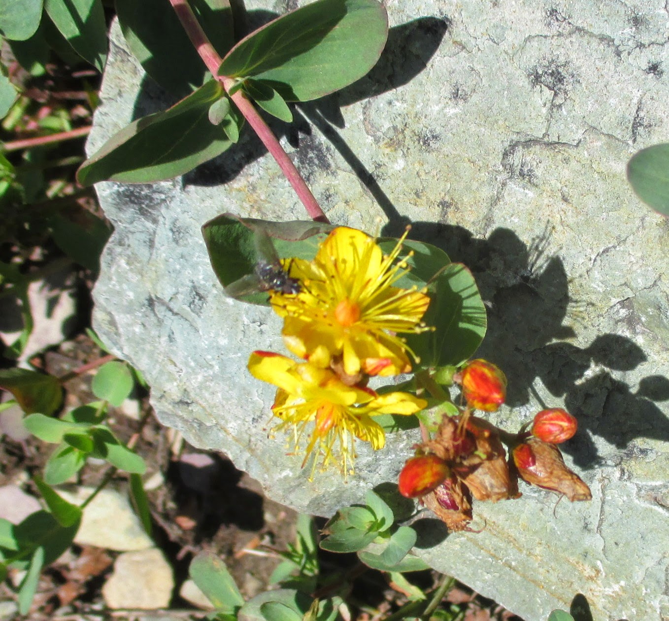
Buckwheat
Butterweed
Cascade Mountain Ash
Cinquefoil
Columbine, Yellow
Common Selfheal
Cow Parsnip
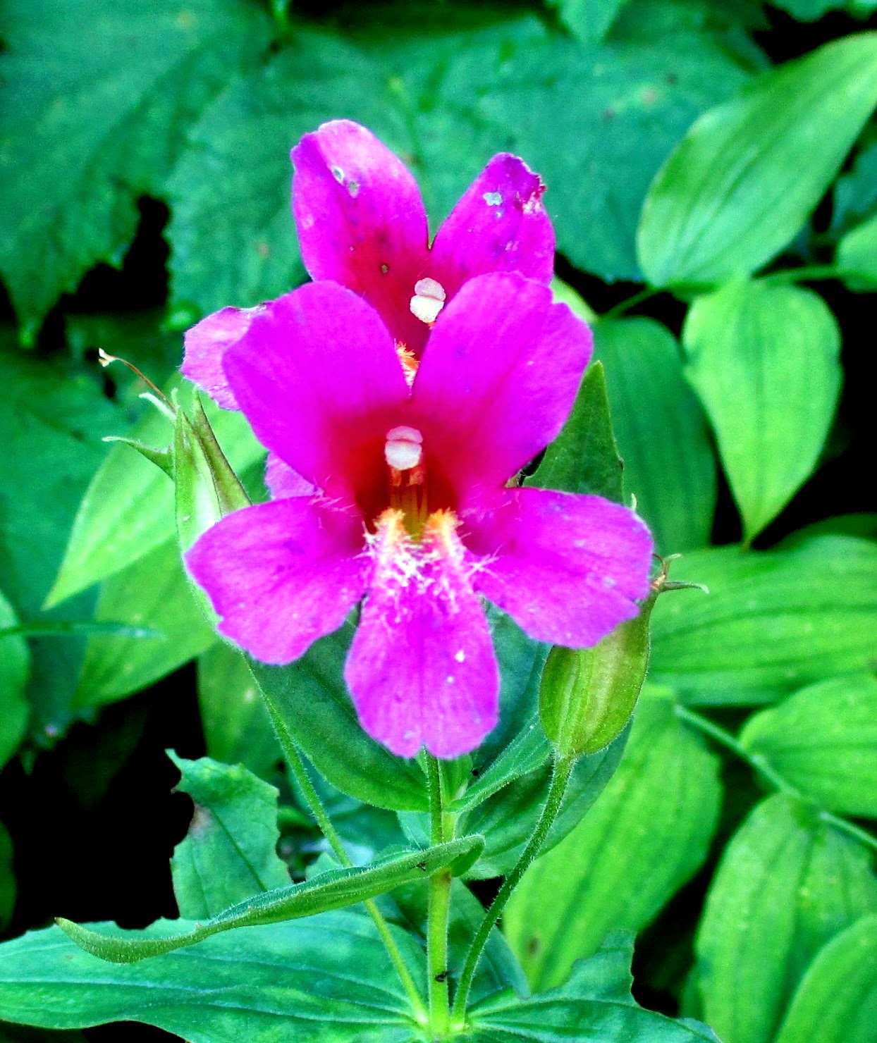 |
| Lewis Monkeyflower |
 |
| Fireweed |
 |
| Indian Paintbrush |
Currant
Devil’s Club
Elderberry
Elephant Heads
 |
| Leafy Aster |
 |
| Vine Maple |
 |
| Buckwheat |
False Hellebore
Fireweed
Fleabane - purple
Forget-Me-Nots, Wood
Gentian, Bog or Explorer’s
Goldenrod
Harebells
Huckleberries (both lowbush and highbush)
Indian Paintbrush
Lewis Monkeyflower (pink)
 |
| Orange Agoseris |
 |
| Common Selfheal |
 |
| Beargrass |
Orange Agoseris (False Dandelion)
Pearly Everlasting
Penstemons
 |
| Still working on this - type of wintergreen? |
Salmonberry
Serviceberry
Subalpine Spiraea (rose colored)
Thimbleberry
Vine Maple
Wild Onion
Wild Raspberry
Wild Strawberry
Wooley Mullein
Yarrow (white)
Several white flowers and the fungus flower to be identified!
WILDLIFE SIGHTINGS
 |
| Big bull moose at Josephine Lake, Many Glaciers |
 |
| Big Horn Sheep on trail at Grinnell Glacier |
 |
| Mountain Goat, Hidden Lake Trail |
 |
| Hoary Marmot, Hidden Lake Trail |
 |
| Pika, Highline Trail |
 |
| Mule Deer, Highline Trail |
 |
| Golden Mantle Ground Squirrel, Avalanche Lake |
 |
| Caterpillar of some type, Avalanche Lake Trail |
 |
| As close to a grizzly as we got! |


