MONDAY, March 30
Edgewood, NM to Cortez, CO
318 miles
A
chillier night than anticipated after a warm day! We didn’t put the heater going last night and
the trailer was a brisk 40 degrees when I got up at 6:30 this morning. Brrr!
But it warmed up quickly as the sun rose over the horizon.
Rick
and I got the trailer packed up, went inside to eat breakfast and saw goodbye
to Regan, Jax, Mom, and Jed, and we were on the road by 8:25! Right on schedule!
 Our
stop in Moriarty took longer than planned however. We pulled off at the Travel America center
because it advertised free RV dump station.
Well, a 7Up truck was blocking the dump and there was now a charge. First the lady said $10 and Rick balked. She switched it to $5, so we went ahead. By the time Rick got it worked out the truck
was leaving. Job accomplished.
Our
stop in Moriarty took longer than planned however. We pulled off at the Travel America center
because it advertised free RV dump station.
Well, a 7Up truck was blocking the dump and there was now a charge. First the lady said $10 and Rick balked. She switched it to $5, so we went ahead. By the time Rick got it worked out the truck
was leaving. Job accomplished.
We
chose our route today as a variety from the boring route going back through
Albuquerque (we had driven that road enough this week!), on to Gallup, and up
to Cortez. That is probably the shorter
route, but today’s route was MUCH MORE SCENIC!!
We decided to cut up to Santa Fe from Moriarty, then past Ghost Ranch
and up to Pagosa Springs, Colorado. From
there across the southern edge of Colorado to Cortez. A great choice!!
 |
| Rock formations south of Ghost Ranch |
 |
| Northern NM |
 |
| Meadows and mountains near Pagosa Springs |
The
skies were rather dusty or hazy in the early hours, but as we neared Ghost
Ranch and the northern parts of Hwy 84 near Chama, the views were clearer – the
red rimrock, the hoodoos, and distance snowy mountains. The meadows became green with new grass, the
hills covered with pines. After 5 weeks
in the desert southwest, what a welcome drive!
We were going to stop for lunch at one of two picnic areas which we
never found. Hence, Rick ended up
driving clear to Pagosa Springs. We
gassed up and eventually ate lunch in the City Market parking lot, recalling
various locations and landmarks from our month here on our first
volunteer-cation. I took pictures…plenty
of them!
 |
| Chimney Rock west of Pagosa |
 |
| Just west of Durango |
 |
| Mesa of Mesa Verde National Park entrance |
Hwy
160 from Pagosa through Durango and on to Cortez rolls up and down as it
crosses at least six major rivers draining the mountains of SW Colorado. Plenty
of good views, beautiful ranches and meadows.
We passed the high butte mesa of Mesa Verde National Park and descended
down into Cortez around 3:30pm. Full
tank of gas and then we find the Sundance RV Park across the street from the
Colorado Welcome Center. Not the
cheapest place in town, but we get a spot, settle in, and take a leisurely walk
around the extensive city park to stretch our legs. We were surprised upon signing in to the
register at the RV park to find Jennifer and Rick Holden from Baker City had
been there just 10 days earlier!
Forecast
is for 34 degrees tonight. Guess we will
keep the heater out and ready to use!
 |
| Southern Colorado mountains |
 Tuesday, March 31
Cortez, CO to Tooele, UT
371 miles
I
think the heater kept things warmer last night as it was 57 in the trailer when
I got up this morning! A beautiful
morning, but a cold front is coming in and tomorrow is forecast for 20 degrees
cooler in Cortez, and a low in the 20’s for the night. (We heard on the news that Denver hit the
80’s on Sunday, but could have snow soon!
LOVE Spring weather!) This
cooling trend is a good sign to get home now!
 |
| Rick's favorite Beehive formation north of Monticello |
I
drove first today from Cortez up to Moab.
A pretty morning and Rick even took a few pictures with the camera! Snow on the peaks, winter wheat poking up
green shoots in the fields, and tilled RED soil waiting for planting. The high country between Monticello, UT and
Cortez is prime wheat, pinto bean, and sunflower growing areas.
 |
| Sun on rocks entering Moab |
 |
| Leaving Moab |
We
stopped briefly at a rest area about 15 miles south of Price to grab a bite to
eat and restrooms. From there…Rick drove
straight through to Tooele from there. (Past Provo to Lehi and then on Rte 73
to Tooele – a new route!) A rather long haul!
But we arrived at 3:30pm and now are set to cross the Great Salt Desert
in the morning and will have avoided ALL Salt Lake City traffic and
congestion! Hurray!
 |
| Willows blossoming near Price |
 |
| Dropping down into Spanish Forks |
I
got two more walls finished for the needlepoint crèche stables AND spent time
highlighting the roads we have driven in several states in our atlas. A fun activity, especially when we have NEW
roads to highlight.
 |
| Road into Tooele - not exactly SLC congestion |
Quiet
night. Early night! But I am going to call my bro’ tonight!
 WEDNESDAY, April 1
Tooele UT-Nevada-Idaho-Baker City, OR!!
526 miles
I
should have know this morning that once we got into Idaho, the homing pidgeon, ‘horses
to the barn’ syndrome would set in! And
once we committed (as we passed the RV Park in Glenn’s Ferry) we felt good
about it! And I drove at least 225 of
those miles, so my share!
 |
| Mountains west of Tooele |
 |
| Sun rays of morning sun breaking through clouds |
We
were out of Tooele by 8am heading west into a mild but not horrible wind across
the flats of the Great Salt Desert. The
mountains were pretty in the morning sunshine with shadows and tips of
snow. I drove until Wells, NV, with a
brief stop at the rest area at Bonneville Raceway and the Salt Flats, just a
few miles east of Wendover and the
Nevada border. Rick got some great pictures of the Humbolt
Mts. as we descended into Wells. They
were beautiful. Wells completed our
giant circle….the rest of the way home retraces our original route.
 |
| Humbolt Mountains as you drop down into Wells, NV |
We
gassed up in Wells and got an early lunch at the Subway. That fortified Rick for the drive up toward
the Idaho border and I-84. This is NOT
the shorter way from Salt Lake, but we sure did avoid a lot of morning SLC
traffic.
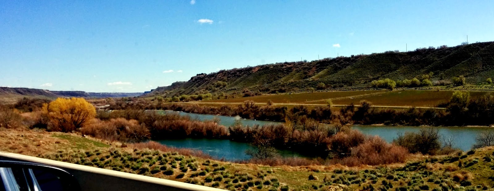 |
| Crossing Snake River north of Buhl on Hwy 46 |
We
gassed up again in Filer (between Buhl and Twin Falls) for the final 45 minutes
into Glenn’s Ferry. At that point it was
just a little after 2pm and we realized we could be HOME by 6pm Pacific
Time. I was good for another stretch at
the wheel, so once on the interstate, Rick pulled over and let me take the
trailer through the WIND TUNNEL into Boise!
And boy was there a west head wind
coming at us. It probably would
have been
better in the morning. We
joked that whatever we saved in not paying for another night’s RV spot, we used
up in gas! Not the easiest 80 miles of driving
for me – hard to keep up a decent speed but not push the engine too hard when
you have 30mph coming against you! LOTS
of trucks and cars passed me, but we made it to the rest area just east of
Boise where I let Rick tackle the construction and traffic of Boise and on
home!
 |
| Snake River near Farewell Bend, OR |
 |
| Lush hills of Burnt River canyon |
 |
| The FIRST reminder that I am almost home. |
 |
| A tint of the yellow balsam color! |
 |
| Not the best of my Pleasant Hill Elkhorn shots... |
That
ends another Southwest Spring Swing for volunteer work. It was a good trip. A few new roads, new faces at CHRPA, and a
quality visit with Mom R, Jed, and Randy's family. Some homes
that we know we made a difference in and spread a little of God’s love. Some incredible vistas and reminders of God in the beauty of creation.
PS. One of those little 'math things' that I find amazing. Our trip down to Tucson was 1215 miles. Our trip home from Edgewood to Baker City clocked in at..... 1215 miles. Go figure! God figures!!