Monday, February 24, 2014

Part 1 of Spring Habitat Travels 2014

Baker City to Las Cruces

Monday, February 24
Baker City, OR to Brigham City, UT
410 miles

     We are off again!!  After a whirlwind 10 days home between our trip to Hawaii and now, we are all packed up in the Jay Feather (the BIG trailer.... or as Scott Cloverdale of CHRPA said, 'our gigantic behemoth of a motor home'!) and on our way south to pound some nails and slop some paint!  
      We had a little snowfall on Saturday night, but by this morning all was melted and it was a beautiful sunny drive down I-84!  Rick drove to Caldwell for our first tank of gas for the day and some expensive Flying J coffee!  I drove through Boise and all the way to Jerome (near Twin Falls) where we stopped at another Flying J for more gas (but at a cheaper price!)  Lunch was at a rest stop just before Jerome where we grabbed some crackers, cheese sticks, and a little fruit.  Rick took us the final 160 miles on in to Brigham City, where we are camped at Golden Spike RV Park.  We have almost camped here several others times, but have always changed our plans!  It is a nice park!  
     I felt much more comfortable driving today with the Feather, but the test will be how comfortable I am on the two lane highways!  I still can't see squat - just a couple car lengths back on either side, so you have no idea what is behind you on the road.  Huge trucks come out of nowhere to pass!  
     Beautiful sunset to the west while Rick and I walked five laps around the park to stretch our legs after the drive.  Leftover soup for dinner (from the huge batches I made last weekend) and we walked over to the Old Grist Mill Bakery near the park to grab a loaf of 'sourdough spinach feta' bread.  
     Snow on all the peaks of Southeast Idaho as we crossed Sweetzer Pass and into Utah.  Beautiful!  
     All five of my pictures today were taken with our new Smartphone - and as soon as I logged both laptop and phone in to wifi, the pictures sync'd over to the laptop.  Nice!  Thank you Jed for setting up that dropbox!  


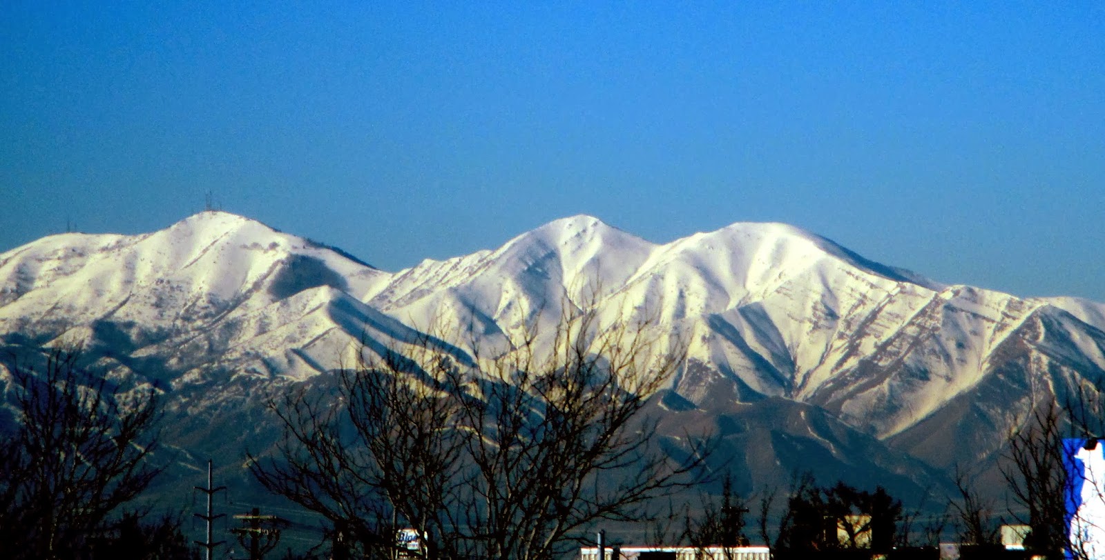
Utah Mountains near Snowville

Tuesday, February 25
Brigham City to Green River, UT
236 miles (yeah, easy day!)  

     Nothing like getting back on the road and into our cozy little back bed of the trailer on a cold evening!  Temps were down around freezing last night, so not TOO bad!  Rick had hooked everything up at the RV park just to make sure it was in good shape after the winter and then we disconnected before night just in case it hit below freezing.  We have done the same tonight with a forecast down in the mid twenties here in Green River.  It is clear outside right now!  
   
 On our way slowly today, as we don't want to hit the Salt Lake City morning traffic - part of the reason we only have 240 miles planned for the day.  So it is 9am by the time we pull out of Brigham City, having gassed up, coffeed up, etc!  
     The next two plus hours are filled with moderate traffic (always trucks, however!); the usual narrow lanes of I-15 as it winds through SLC, and GORGEOUS mountain vistas!!  A little haze in a few places, but overall, blue skies and white mountains!  Too bad SLC is so big and trapped between lake and peaks - the views on a good day are amazing (as you gaze OVER the oil refineries, gravel pits, and rock crushers!)  I forgot how great the mountain ranges are to the west - first on the penninsula forming Willard Bay and Bear River Bay, and then west of Toelle and Provo.  All in all, as smooth a drive through Salt Lake City as possible.   

     We stop in Spanish Forks to gas up again (so much for driving 400 miles at a whack as in the Prius and still not on empty!) and then head through the narrow cleft in the mountains (and the wind farm that sits right there picking up the canyon breezes!) on Route 6 over Soldier Summit and into Helper and Price.  We have never taken the big trailer over this route, but it cuts 75 miles off the trip to leave the Interstate at this point.  And Hondi pulls just fine up the grade and down the steeper east side.  
Wind farm on Route 6

     More and more snow as we near the summit and then.....rocks!  The snow is all on the west side of each ridge!  
Nearing Soldier Summit
     We stop at a city park in Wellington, a very small energy/mining town east of Price.  Not much there, but the park was nice (although the restrooms were closed.)  Grabbed a little lunch and then push on to Green River, just 60 miles on down the road.  
     We made our reservations with Shady Acres RV Park on the internet.  Good thing I made a copy of my reservation!  The main owner was called away on an emergency and the gal in charge didn't really have a clue what was going on.  Net result - two trips to the office at the little store next door, a switch of sites, and we find we have winter rates for winter service - no water.  There is one pump 'on' for you to fill your tank, but we didn't want to do that with the forecast.  So we drain the black tank, and then just set up with no water connection.  The change in sites was for one right across from the bathhouse!  
 
It's a little lonely at the park - I think
there are 4 rigs here! 
   So...we are all set up and ready to relax by 3 pm!  The sun is warm and feels GOOD!  We don our shorts and sit outside for the next hour or more, drawing, puzzling, etc.  

     Before dinner I walked a couple BIG laps around the park (over 100 sites and I figured it was nearly a .4 mile loop); dinner of leftover soup from last week; and a quiet evening of cable TV (more Big Bang Theory!), reading, journaling, etc.  Tomorrow will be our longest day into Albuquerque.  Rick's mom is expecting us for dinner!  


Looks a little like the Elkhorns, doesn't it?


Wednesday, February 26
Green River UT to Albuquerque NM
445 Miles

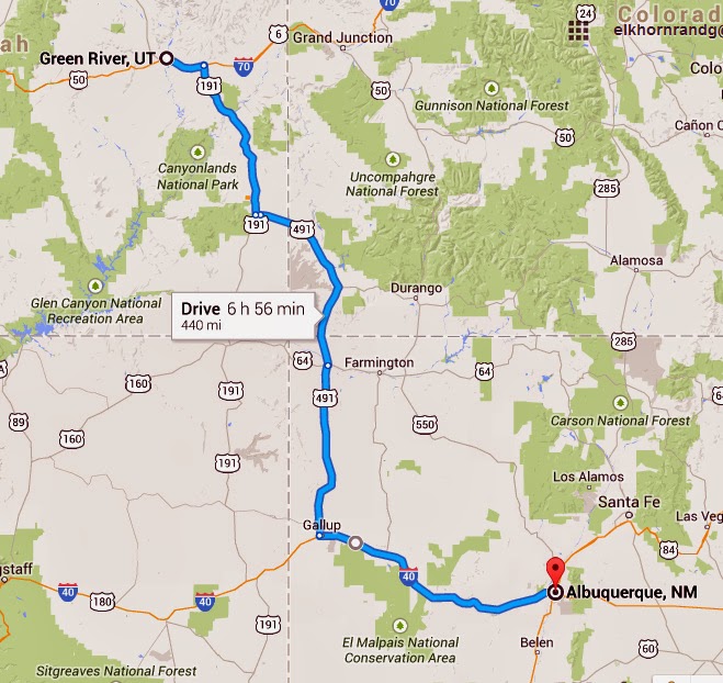
     Another beautiful day to travel.  It is cool and crisp outside packing up in Green River, but a blue sky with a few puffy white clouds!  We are on our way by 7:45, having gassed up with our campground credit and coffee'd up with a 2 for 1 deal also.  I am driving first today, so Rick is on 'camera duty' going through Moab, etc.  (And he does well with the responsibility!)  
     I always enjoy driving through this corner of Utah - there is a beautiful mix of high snowy peaks and red rock canyons, mesas, and sagebrush/juniper plateaus.  The early morning sun strikes the cliffs with a warm glow.  I drive 100 miles down to Monticello, UT, where Rick takes over as we grab a fresh coffee at the gas station.  
   
Southern part of Moab Mountains
 Into Colorado, as we continue listening to a book on tape - a CIA terrorist story that has us both wrapped up in the saga.  We stop briefly to gas up in Cortez, at $3.34 the most costly stop of the trip.  Rick continues to drive the next 125 desolate miles down through the Indian reservation to Gallup, and we finish the book in the middle of this section.  

     Today is classic Georgia O'Keefe skies in New Mexico: deep blue and white clouds.  
NW corner of New Mexico

     Quick stop just east of Gallup at the Pilot to gas up and grab some lunch.  We are back on I40 and I drive 100 miles just to the west side of Albuquerque - Rick can take us into Mom's!!  I didn't want to tackle Wyoming Avenue just yet!  I am feeling a little more comfortable with this trailer, but still very conscious that it is WIDER than the truck! 
     We arrive in Albuquerque around 4:15p, beating the commuter traffic!  Park the truck and trailer in the little corner parking area next to Three Fountains - only one other RV and a utility trailer parked there.  Unload necessary items (including the freezer and fridge since the trailer will not be plugged in and we don't want to use up our propane) and then lock everything up tight!  
     Evening out at Village Inn with its Pie Day Wednesday (free pie with every entree!) I save mine for tomorrow AFTER I weigh in at Weight Watchers in the morning!  

Near Arches NP as you drop down into Moab
THURSDAY and FRIDAY, Feb. 27 and 28
Mom time in Albuquerque.....


Pile of bags finished for Chemo Kits
     The past two days have been rather relaxing, just hanging out with Mom while fixing a few small things for her.  
     Thursday morning I walked over to WW to get that 'out of the weigh' and then worked to stitch up 11 of the Chemo Kit bags to send up to the church in BC.  I had cut them out Wednesday evening.  Had to make an extra trip over to Wal-Mart to purchase more Heat 'n Bond, but otherwise Mom's machine plowed through them pretty quickly....ok - about 3 hours worth! 
     Rick took long walks both mornings...I managed my exercise walking down to the trailer and back, Jo'Anns and Walmart!  (Oh and ALWAYS using the back staircase instead of the elevator to come back up!) 
     Thursday night Mom made a ham loaf and we ate up our broccoli and asparagus with it.  We watched a little TV.  After Mom went to bed, Rick stayed up to watch the UCLA-Oregon Basketball game and I talked with Jed, who was in the middle of a power outage!  (He said I was lucky cause the lights came on while we were talking!)  
Spires of the Old Town mission

     Friday we had an outing!!!  We drove down to Old Town and poked around the shops for a couple hours.  The old mission church that anchors the Old Town plaza square was gorgeous in the clear blue skies!!  Plus the same pan flute musician was playing in the courtyard where we enjoyed lunch a couple years ago (or was that just last year??)  Mom found a Celtic shop where she was able to purchase a long desired Celtic cross necklace.  A couple gifts and t-shirt purchases, but mostly exploration. 
Enjoying the sunshine
and music

     I also mailed the package to the church from the little post office next to the square (I think it is there mostly to ship purchases people make!)  I had gone dumpster diving at Mom's complex for a box and the best I could find was a pizza box (ironically in the bin marked 'no pizza boxes!')  The PO worker laughed at my box and helped me cross out some of the lettering.  She was most helpful!  But the bags are on their way!
     Enroute home from Old Town we stopped at a Lowe's and picked up a few pansies and to pot on her deck.  A little touch of spring!!  
     We met Rachael and Patty at Papa Felipe's for dinner.  Always good - their sopapillas are huge and delicious.  (And definitely on the WW menu!)  I shall dine on my leftovers for breakfast before we leave Saturday morning!  Randy was still out of town for work - he is scheduled to fly in Saturday evening so we won't see him this trip!
     
Rachael and Patty!
Mom did ask Rick and me to hang the tile that Luke sent her from the Holy Land on the wall, so we got it mounted and hung.  I even loaded a 'Level Tool' app to my new phone to help us out!  (OK...confession.  Rick had it all mounted by the time I got the app loaded, but I'll have it for NEXT time!) 

     Early evening to bed on Thursday! We were all tired!  
Holy Land tile

The picture at right is for you, Luke!  See what is now mounted on Grandma's living room wall!  She says thank you again!
Saturday-Sunday, March 1-2
Albuquerque to Las Cruces, NM
229 miles
Easy route down I-25

      It is a windy and sunny/cloudy day in New Mexico!  A storm is brewing and everyone seems to be desperately hoping for a good rainfall!  We enjoy a relatively leisurely morning, and by 10:45 we are ready to say goodbye to Mom and hit the road south to Socorro. 
      We get around 7 miles to the gallon heading down to Socorro!  What a head wind!  The clouds and skies are beautiful, the sun ducking in and out, but the wind, and the dust from it, is intense! 
     
Stormy skies as Jed picks
us up at RV park
We check in to Casey’s Socorro RV Park, one of only two choices in town!  Nobody is in the office, so we pick out a spot with full hookups, pay our $28, and give Jed a call!  So we don’t have to unhitch, Jed is our wheels for the afternoon! 
Rick and Jed in 'jeep'!
      We head down to Old Town Socorro and the Plaza area.  Basically ALL the stores are closed – things don’t really hop apparently in downtown Socorro on the weekends!  A new addition to the town plaza impressed us.  It is a Veteran’s Memorial space, still incomplete, but the children’s playground was awesome.  A military theme with cammo tarps, etc., airplanes, jeeps.  We talked with one of the city planners who stopped to talk with us.  A quick walk down to San Miguel’s Church, a historic but still active parish. 
     
San Miguel Mission - the south wall
dates back to 1598!
We took a little side trip east of town to the Rio Grande.  It is running muddy right now, and the trees were FILLED with mistletoe!   
At the Rio Grande
      Then Jed took us to The Bodega for dinner.  He said it was a good place for innovative burgers, but both Rick and I wondered when we first walked in.  Candlelight, white tablecloths, black cloth napkins….pretty classy!  But….the burgers were excellent!  Rick had a wild game burger – combination of deer, elk, moose, wild boar, etc.  I had a black bean/portobella mushroom burger, and Jed something else with waffle sweet tater fries!  A good meal!  The place wasn’t busy so we took our time talking. 
We found daffodils in
Socorro!!!
     Quick stop at Wal-Mart to pick up a few breakfast items as we are going to entertain Jed for breakfast at the trailer!  Then over to Jed’s house to watch the movie, Now You Seen’Em, on his ‘big screen’.  Literally BIG – Jed has the movie on his laptop and shows it through a projector, something like a 6’ by 15’ wide screen theater!  A fun movie! 
   
Jed hands Rick a printed copy of
his ALMOST finished dissertation!
  The wind finally has died down somewhat for the evening.  Jed takes us ‘home’ around 10:15 and says he will return in the morning.  We checked out the distance to walk to the Presby church to attend the 9am service, but it seems a little far, so…..don’t think that is going to happen in the morning! 
     And….it didn’t!  I spent the morning time coloring in some of the prayer mandalas I had already drawn.  Jed showed up at the trailer at 11 and we ate egg burritos and some of the blueberry coffee cake that Rick picked up last night.  Jed helps us pack up and shortly after noon we are on our way south the final 140 miles to Las Cruces. 
     We did hear a little rain fall during the night.  No evidence of it this morning, however!
     The wind isn’t quite so strong and has turned a little more westernly.  Rick says it is a little better than Saturday!  Big puffy clouds, blue skies, and distance mountain ranges, some of which have a dusting of snow.  I am excited to see the Organ Mts. as we near Cruces, but they are snow free.  L 
     We pull into our Habitat ‘campground’ right around 2:30 pm and Dyana quickly announces we are in our corner spot – it is a good ‘fit’ for our little trailer. 

     Rest of afternoon getting settled, grocery shopping at Albertsons, laundry, phone calls, etc.!!!  It is going to be down in the 30’s tonight, but then warming up to mid 70’s during the day all week.  Should be good!  
The Organ Mountains welcome us back to Las Cruces!!


Wednesday, February 5, 2014

HAWAII !!!!!

Oh my goodness!  The Rembolds haven't posted 'from the road' since our Christmas Greetings!  Everyone should have had a good break by now!  Time to travel again!

TUESDAY, Feb. 4  Leaving Baker City
Clear roads amid the snow fields heading west to Portland.
Tucker performed for us!
     We left Baker City around 9:30 am to sunshine and clear skies.  After yesterday’s 3 inches of snow, the weather was a welcome sight.  Meacham was a landfield of chains and trucks, but we made it safely over the pass.  The trees and hills were gorgeous – sunshine on heavily flocked Ponderosas.  A strong East wind along the gorge, and then light snow falling in Portland as we arrived around 3pm.  Portland was supposed to be clear and sunny today!!  Dinner with Liz, Dave, and Doug, and then a quick visit with Gretchen and Tucker before an early turn in.  Liz and Dave will drive us up to the airport, leaving around 5am. 
Snow flocked trees over
 Blue Mountains

WEDNESDAY, Feb. 5  
Plane Trip to Kona....Arrival!
     A restless night.  I think I am excited!  Smooth drive up to the airport, Rick grabs a couple of breakfast burritos at MacDonald’s while I eat one of the yogurts I brought along.  We board around 7am – seats 19A and B, right over the wing on the left side of the plane.  It is full! 
     As we left, we could see all the Cascade peaks in the morning sunlight.  First Syt. Helen’s and then Rainer came into view from behind the southern mountain.  Then Adams, Hood, Jefferson, and the Three Sisters.  With the strong East wind we departed heading East first, so our views of the mountains were amazing. 
St. Helens and Rainer as we leave PDX.
     It has been a smooth flight so far.  A few bumpy patches.  Rick closed the window on the plane as the bright sunlight was getting hot and directly in our eyes.  I drew a little, watched the animated movie, How to Train a Dragon, wrote my morning devotional and got started writing here.   A little soduko and reading rounded out the flight!!  Rick watched the movie Skyfall on his Kindle.  Luke got us all set up with plenty of viewing pleasure for the flights!   We snacked on food we brought along, although the Hawaiian Pancakes they were serving for $6 smelled pretty good.  
      My seat mate is a postman from Illinois, transplanted to the Islands over 20 years ago.  He is flying HOME to his story (He came over to Portland to watch the SuperBowl with his son and family ….proudly wearing his Seahawks shirt back!) I later check on the internet as he and his wife have a vacation rental ( Hale Maluhia - Peaceful Place.  His name is Ken Smith and their place looks amazing!  As we neared the Kona airport, we pumped Ken for information about places to see, good fish sources, etc.  As an ex-postman, he KNOWS the town!!  
Mauna Kea with its white cap. 
     We are about a half hour late in arriving - a head wind slowed us down!  As we wind down into the airport, we spot Mauna Kea and Mauna Loa - both marked with white patches of snow on the summits.  The Kona airport
Walking off the plane at
Kona airport.


is set about 12 miles north of town on a flat strip of lava land along the edge of the ocean.  The 'airport' is casual - no expanding walkways to the plane here.....walk down the ramp!!  Everything is so open air.  We get our luggage and discover we have to take a shuttle bus over to the car rental place.  Half hour later, we leave with our little silver Madza sedan!  Down into Kona to the Walmart to pick up a few groceries and then to find the Wydham on the south side of town.
Cruise ship in harbor. 
 
Beautiful hedge leaving airport
   Kona is HOPPING!!  We later discover this is common when a cruise ship is in the harbor.  After relaxing for abit and eating an early dinner (since we didn't really eat much on the plane except for a bag of yogurt covered pretzels!), we walked back to town from the resort, checking menus, shops, beaches, and getting a feel for Kona itself.  The cruise ship is massive out in the harbor, but it left shortly before sunset.  The sky was glorious as we watched the sun slip down behind the clouds into the sea.  Rather like watching it at my mom's in Bandon, only with palm trees in front instead of gorse!

Sunset
     
Ging and Rick on Kona beach
We are probably going to call and cancel our trip to the top of Mauna Kea - reluctantly.  If we cancel before noon tomorrow, we can get a full refund.  The forecast is for 80% thunderstorms and cloud cover.  Not sure we will get what we want for the money spent.  We can do a couple of other things instead.  We are going to be on a waiting list for Sunday or Tuesday night if someone else cancels.  There is a good chance the trip will be cancelled anyway, but.....:(  Tomorrow we will cruise the Kona highlights of the island....I need to do a little more reading tonight.  

     We were up at 4:30am Pacific time, so it will be an early turn-in tonight!!  

Beautiful skies!

Our bedroom at the Wydham resort
Rest of condo
View out from deck toward pool area. 

THURSDAY, February 6  
Cruising South Kona Coast! 

VIEW PICTURES SO FAR HERE
    
Today's travels!
      Up and at it this morning after a good night's sleep!  World Mark offers a free continental breakfast and explanation of the island's offerings from an Expedia representative.  Answered some of our questions, and also convinced us to wait and not cancel our Mauna Kea trip....yet!  Birds entertained us constantly during the presentation! 
      So...it isn't until 10:45 when we finally head south to explore the Kona coast south of town.   I can't believe the amount of traffic is on Ahi'i Drive!!  If this is the 'uncrowded' side of the 'uncrowded' island, I will NEVER go to Honolulu!!  
   
Guide shows fresh picked
coffee 'cherries'


A gecko at the coffee farm
 We wind our way down past rocky beaches, resorts, and an abundance of lava!  Our first stop is Greenwell Farms Coffee Plantation - free tours explain the coffee growing process.  I learned alot and appreciate more the labor intensity necessary to produce good coffee.  Makes Fair Trade even more important!  The growing season is over here now, the trees pretty well stripped of their 'cherries'.  Coffee beans are RED on the tree!  Once they are picked, they are squeezed to pop the slimy, sugary white bean apart from the red skin.  The sugar is rinsed off and the beans are sun dried on concrete slabs for nearly a week.  A thick parchment skin is then removed, as well as a thin inner lining (both by pressure air).  The now green bean is ready for shipment to coffee roasters.  It was pretty interesting!  The grounds also had plenty of beautiful flowers, huge avocados, and banana trees! 
Cherry skin and slimy bean

Staggered coffee trees, fresh stumps on left.
     The coffee trees are trimmed down to the stump every 4 years right after the harvest.  The following year no beans are produced, so 1/4 of the farm is always 'idle' or non-producing.  They had just trimmed trees so we could see the progression.  
     In to the gift and sample shop to taste some chocolate macademia nut coffee as well as just macademia nut.  Liked the latter better which was surprising.  Bought a few gifts and then headed up the hill to the Historical Society which bakes Portuguese Sweet Bread in an old fashion stone oven on the grounds.  Might have bought some, but the last batch out didn't get quite done enough so they were pulling it!  It is not as exact a science when coals are used!  
Small bird near bay!
Bread coming out of the
stone oven

     On down the highway (speed limits are around 45 or 50 max - it is a winding road!  We have pulled up to about 1500' above the beach, the lava flows creating amazing hills and cliffs.  We cut down shortly after leaving Greenwell Farms to visit Kealakekua Bay and a bite to eat!!  The road is windy and steep as it drops DOWN to the reef and rocky beach park.  We sit on the sea wall and eat lunch.  Captain Cook's burial site is across the bay.  At the park is a Sacred Ground from Kamehameha one time home.  
Kealakekua Bay

     From the bay we head south on a narrow road through a flat lava plain toward the City of Refuge:  Pu'uhonua O Honaunau National Historic Site.  This is where people who broke Kabu in any manner -whether trivial or critical - could seek refuge and be absolved of their crime.  It is a point of lava reef, filled with white sand and lava outcroppings, palm trees, and ponds.  Little remains of the original thatched structures, but replicas have been built.  Many of the original wood statues remain. 
Sea turtle under water!

      This is a turtle site - and I did see one in the tidal pool, but it never surfaced, so really hard to see.  We discovered tilapia breeding pools, where the eggs are laid in round depressions, and then the males kick the female out and guard the eggs themselves (the females will eat them).  The Honaunau Bay is filled with swimmers, snorklers, etc.  This was a fascinating place to see!  
Tidal pools and palms at
City of Refuge


The ki'i guarding the refuge

     UP from the beach we travel to find the Painted Church Rd.  I wanted to see the St. Benedict's Painted Church - a miniature Gothic chapel covered with paintings of the Bible and Christ.  The ceiling was sky blue and palm fronds!  Back of the chapel is open with lattice work to the west - the ocean breezes flow through!  
 
Ceiling front of the Painted Church
   On down the Painted Church Rd. to Paleaku Peace Garden.  The admission fee ended up being more than we planned ($10 each) so Rick quickly volunteered to read in the car while I went in!  The garden was more a tribute to the unity of all religions in attaining peace on our globe.  There were shrines or gardens for Islam, Judaism, Buddhism, etc.  Native American Medicine Wheels and Fire Circles, as well as a labyrinth for Christianity.  The labyrinth was out on the edge of the slope overlooking the ocean far below.  It was spectacular and spiritual.  
Multi-colored hibiscus


Buddhist shrine and bay

Labyrinth

     One of the most unique aspects of the garden is the Galaxy Garden - a floral interpretation of the Milky Way Galaxy, exactly replicated in scale.  Hibiscus flowers mark various solar systems within the Milky Way, red rock individual stars, etc.  It is all very complicated.  I expected plantings about waist high - I was lost in the midst of hedges and flowers over my head!  
     As I began walking through the spiral galaxy garden, I received a phone call from Mauna Kea Summit Adventures!  They had a cancellation for Monday night!  So....in light of the pending poor weather for Friday night, I made the decision (since Rick was in the car!) to ok the change.  It paid off to get ourselves on a waiting list!  
     Time to head home!  Rick is getting hungry.  We stay on the main highway 11 back up to Kona, amazed at the traffic as we near town.  Quick stop at Safeway to pick up dinner makings (Frozen Shrimp Scampi dinner for two plus salad for me and sweet tater fries for Rick), then back to condo.  
Medicine Wheel at Peace Gardens
     Tonight I booked a Snorkle adventure for Saturday.  Looks like a schedule is starting to 'gel".  Now to figure out when we go to Volcanoes and when to Hilo or north side of island.  Watching a little Olympics on TV tonight.....
Palm reflections in pond at City of Refuge

Flowers in front of St. Benedict's Painted Chapel

     
FRIDAY, February 7    Exploring the North Island - Cowboy Country and More!
133 mile Loop Trip to North tip of Hawaii

View pictures from today

    Another day in paradise!  Today's weather was still going to be marginal...am I secretly hoping to find that Mauna Kea cancelled tonight because of the weather???  It is overcast in Kona as we head out around 9:30am to explore the northern tip of the island.  Views out toward the ocean are limited, and the peaks themselves are not visible of course!  But....we find the drive fascinating as we wind gradually up to the 3,600' level on the flanks of the northernmost volcano - now extinct.  We pass over lava flows as recent as 1859, some from Mauna Loa and other from the smaller Hualalai (the 8200' mountain just east of Kailua-Kona).  
Dry bunch grass on the lava slopes. 
     The landscape is DRY!  Prickly pear cactus and agave plants, with tall spires now dried, mark the terrain.  Lots of dry grass bunches spread among the lava flows.  In a few places there is evidence of forest fires.  As we wind down into Waimea, about 45 miles from Kona, we enter the Parker Ranch estate, a HUGE 150,000 acre ranch.  This was cowboy and cattle country at the end of the 1800's and largely contributed to the growth of the Big Island.  Until we reached the ranch area itself, we wondered how on earth cattle could maneuver around the lava!  
Near Waimea, this hill was the training
ground for the Iwo Jima soldiers.

     At Waimea we head slightly northwest to Route 250 which travels the spine of the volcano down to the town of Hawi on the north coast.  What a beautiful road!!  We hit our high point and clouds, and then dropped down into sunshine, and GREEN fields and rolling hills of grass.  Sheep, cattle, and yellow flowers everywhere.  So rich in spring green colors.  
 
Along Route 250
   We cut across to Kapa'au and the original statue of King Kamehameha (he was born near here).  We are bound for the end of the road at the Pololu Valley Lookout. The view is southeast toward the remote and wild Waipi'o Valley of waterfalls.  This is an area we won't get around to visiting.  So remote.  We hike down the trail about a third of the way toward the beach to get a few views.  It is steep and VERY warm and muggy.  The only saving grace is the breeze blowing.  
Above Pololu Beach

     Back into Hawi to find Luke's Place, a little cafe Rick found in one of the guidebooks.  No luck.  After searching for it and another place, we give up and find the Sweet Potato Kitchen.  Outdoor eating, totally vegan, and cash only.  Rather quaint, so we try it out!  I had a salad sampler (with only 2 of the 3 choices, because the Quinoa one wasn't ready yet!)  Rick had a beeT steak (not beeF) with gravy, sweet taters, and wilted greens.  We ordered a lemon sweetgrass tea and a lilikoi drink, which is Hawaiian for passion fruit.  Pretty good stuff!  
   
Lunch stop!
 Our drive south now is along the coastline back to Kailua-Kona.  Parts of this stretch are remote, barren stretches of lava flows, others house the most expensive resorts on the island.  We avoided that section!  We did stop at Pu'ukohola Heiau National Historic Site near the town of Kawaihae.  Here is where Kamehameha had a temple (Heiau) built and defeated the local ruler, eventually uniting the islands.  Pretty interesting area, although we didn't walk down to the actual ruins.  
Beautiful artwork at the NHS...this
story of Kamehameha reminded us of Moses!

     Today I got some answers to some of the plants we have been seeing.  I identified breadfruit (ulu), the noni plant, and I now can identify plumeria trees!  
   
This is breadfruit. 
We stopped at a discount fabric store just north of Kona to pick up some material to make some Hawaiian clothing.  A pretty good deal!  

    Realized I forgot to pick up a waterproof disposable camera today, so we are bound for Walmart early in the morning before heading down to the Seaquest dock for our trip!  
     Dip in the swimming pool and a relaxing evening!!  Aloha! 
Along Route 250, a clump of flowers amid the barbed wire. 

Overlook to the Pololu Valley and beach.
SATURDAY, February 8  
SNORKELING the Tropical Coral Reef

View pictures from today

     Up early this morning to arrive at Wal-Mart at 7.  I pick up two cameras at $10 each, figuring I can take one back if I decide not to use it.  Traffic is sure better this early in the morning!  We head south on 11 and take
The Seaquest 'Office'
Kamehameha||| down to Keauhou Bay and Seaquest Adventures.  Not the easiest place to find since their physical presence on the bay disappeared in the tsunami which followed the Japan earthquake.  They have a truck with a sign on the roof!!  Steve and Sarah were our guides and they were super.  A total of 6 in our group - three couples.  Rick and I ended up split on the two front seats which was perfect!!  I love the front of the boat!  We were traveling in a Zodiak float boat - nice and bouncy smooth on the water.  

   
Yes, Rick, this is retirement!
 We travel south, eventually below the Place of Refuge NHS to a bay where Steve shows us a rather deep lava cave along the shoreline.  Then up to Honaunau Bay right next to the refuge where we get a quick lesson on snorkeling and are turned loose to explore!!  The reefs are all protected so we are cautioned to NEVER put our feet down (the water was too deep for the most part) and to stay away from the really shallow areas.  One step can kill the coral.  
Steve explains something with Hualalai
clear in the distance.

     What a great experience!  I had a little trouble breathing through my mouth ALL the time, but figured it out with a few breaks to clear my tube.  I had the underwater camera strapped to my wrist.  Probably shot half the film in the first 10 minutes!!  Overwhelming at first are the yellow tang fish - about 4 inches in size and everywhere!  And then gradually you start noticing all the other varieties.  Black with white stripes, orange stripes, black stripes, etc.  dark with white polka dots.  We saw a turtle right off, and later Rick saw another up at Kealakekua Bay.  A long skinny fish, called a Coronet or Trumpet fish and a needle fish.  I loved the silence of the water, with the background sound of the crashing waves on the lava reef rocks.  
     
Our first cave south of Honaunau
We snorkeled for about 45 minutes at Honaunau Bay, came up for tropical fruit snacks and juices, and then motored north the 4 miles to Kealakekua Bay.  Here Steve regaled us with tales of Captain Cook (we saw the memorial along the shoreline), we saw a pod of spinner dolphins travel right by the boat, and then we had another 45 minutes to explore this reef.  This spot is shallower right along the shore, but the floor drops off suddenly to the deep blue depths.
Captain Cook Memorial
 The water color was so impressive.  Here I found a few more fish I hadn't noticed before, as well as red pencil urchins tucked into the coral.  Also the coral at this bay was more finger like.  I especially enjoyed a fish, about a foot long, that had yellow on its side and the rest was a tie dye of greens, blues, and purple.  So pretty.  At the very end, I saw a Pennant Butterfly - I thought it was an angel fish at first.  Watched it for awhile as it pecked around feeding on the coral.  Beautiful yellow, white, and black with a long tail off the top fin. 

The 'blow hole'
     We stopped at a few more lava caves on the way back.  I really loved the beautiful water color as the waves crashed on the lava and then cascading down in waterfalls back to the ocean.  In one place there was a 'blow hole' where the water came spouting back out.  
   
Red Hill Monster
 I had to hold on a few times enroute back as the boat bounced along on the waves!  Done about noon - got a little sunshine.  Early this morning we could clearly see all of Hualalai, the 8000 foot volcano near town.  By the time we came back, the mountains were all enclosed in clouds.  

     Traffic back north on Ali'i Drive was horrible, passing the very popular Kahalu'u Beach.  It took us nearly 25 minutes to get back to the condo, putt putting along at about 5 -10 mph. 
     An afternoon relaxing and talking with Moms on phone, doing a load of laundry!  
Our spot at Bubba Gumps for dinner
     Around 4:15 we take off to walk downtown to hit Bubba Gump's Shrimp House for Happy Hour prices and a spot out by the water.  The whole place is a tribute to the Forrest Gump movie.  Pretty funny.  Ping pong paddles on the table with drink descriptions, a bench out front with a suitcase and box of candy on it for pictures.  A separate gift shop to buy Forrest Gump souvenirs.  The prices were fish steep, but Happy Hour was reasonable.  We ended up getting two orders of fish tacos, one of their dip and chips.  Rick got a beer and I tried my first pina colada type drink called a Lava Flow (easy on the rum please!)  It was very good and came with a big chunk of pineapple in it.  
Sunset in the palms
     After dinner we wandered around the shops a little, picking out some gifts.  Back as the sun slipped into a bank of clouds - a red ball in the sky.  
So ends another day in paradise.  

(I will take my underwater film in to Walmart tomorrow and see what we get!  In the meantime......)  
Most common fish we saw: a yellow tang fish
(NOT my picture!)

200 miles around the Big Island today!


SUNDAY, February 9   
Volcanoes National Park and More!!

View today's pictures

     What a gorgeous and glorious day!!!  We took off around 7:45 to take the extra waterproof film back to Walmart and get the other roll developed.  Had to take the film to Long, but by 8:20 we were on our way south toward Hawaiian Volcanoes National Park!  Time to get another stamp for my passport book!!  
West side of island: Wait!
 I thought we went
to Texas LAST spring!
These are long-horns!
     New road from Kealakekua Bay and beyond, passing multiple lava flows, some as recent as 1959, others MUCH older!!  We are high above the ocean shore, as the island drops sharply along
Lava flows along road
this part.  We stop at Manuka State Wayside for a break.  At the south end of the island, which is the furthest south point in the United States, 17 degrees north latitude, we can see the wind turbine farms and the point of land.  We don't take the road down to the 'end', but do experience the high winds that prevail in this area as the breezes escape around the mountains and funnel through here.  Everything is so GREEN as we round the tip....

South end of Big Island.  You can barely make out the wind turbines.  
     As we head northeast toward Volcanoes NP, the hillsides are covered with grasses and trees, cattle, sheep, and more coffee, macadamia plantations abound.  Mauna Loa's round massive is visible in the distance.  We pass a black sand beach and cross over a fault line, where the road is marked 'be careful of rifts in the asphalt.
Mauna Loa in the distance. 
GREEN side!

    We arrive at the Visitor Center around 10:40 (it is about 94 miles from Kona on a somewhat windy road!), check out the displays and gift shop, and watch a very good movie on the 1959-60 eruption of Kilauea Iki.  We learned a few new things about how these eruptions have happened. After a quick bite to eat at the car, we then drove out the Crater Rim Road to its temporary terminus at the Jaggar Museum overlook.  (Much of the SW side of the crater is closed currently due to sulphuric dioxide fumes that drift in that direction from the vent.)  The vent from Halema'uma'u was pouring out plenty of steam/smoke.  
   
Steam pours out of the Halema'uma'u vent. View from Jaggar Museum.
 Time for a HIKE!!  We drive past the VC and turn down toward Kilauea Iki Overlook and the 4 mile loop trail which will also take us to Thurston Lava Tube.  It is the middle of the day and warm, but we figure at least half the hike is in the rainforest trees, so it shouldn't be toooo bad!
I was not expecting a lush
forest around the volcano!


Tree palms lined the
trail!
 We traverse the edge of the crater for about .75 of a mile before descending down, out of the rain forest, and on to the bed of the lava lake.  The rain forest is well documented with signs on the flora frequent.  We learn more about tree palms, the invasive kiholi ginger plants which the NPS is cutting out, and the many plants that regreen the lava beds, erupting from every fissure and crack as the seeds catch and collect the moisture.  Recovery is quick on the Hilo side of the island, as the moist air and frequent rains start new growth quickly after volcanic events.  


Tropical orchid RIGHT
before we drop into crater.
Just before we hike across the lava lake.

     It is warm crossing the lava beds.  What looked flat from up on top is rift with fissures, cracks, mini cinder cones, and sink holes.  On one side we find what appears like it might have been the main vent that much of the lava sank back into.  A variety of plant
This plant is a common
'first responder' after a flow.
life, white patches (salt, limestone?), and both areas of aa and pahoehoe lava.  It was warm, but we were glad we had taken the trail in this direction, as the sun was at our backs and the wind in our faces!  Perfect!  We followed a series of rock cairns, ahus, through the lake bed.  

   
Last view of Kilauea Iki crater with the ahu cairns marking our way!
 Up the switchbacks at the east end of the crater through the forest again....a welcome sight!  Then over to the lava tube....it was a little disappointing in

Entrance to lava tube from
inside. 
Inside the tube
that I expected a half mile tube.  Turned out it was only about 1/8 of a mile, the rest was the return trip through the forest!  Still interesting - a very moist, damp, lava tube - much more narrow that the one in Bend.  It is a half mile along the rim again from the lava tube back to the car at the Iki Overlook.  

     The time is 3 pm and we decide to call it quits at Volcanoes and head north toward Hilo and a bite to eat!!  I drive this short 30 
Hilo parks were lush!
miles stretch while Rick tries to find a good restaurant for dinner!  He decides on Sombats, a Thai place, but when we finally find it, it is closed!!  My cell phone doesn't have an service to look for something else, but we eventually find Happy Valley Seafood Restaurant, with Chinese cuisine.  Perfect.  Rick tries Mediterranean Lamb and I have a Seafood (A little squid in it!) with Vegetables on noodles.  Both are good.  We were hungry!  

Rainbow Falls
   
Check out my little
purple squid on top!
 It is 5:20 as we finish in Hilo...not much time left here for tourist stuff, so we head over to explore Rainbow Falls.  A really nice waterfall that cascades in front of a huge cave in the lava stream.  The trees here are covered with a viney plant (HUGE clefted leaves) that leaves plenty of hanging ropes.  Kinda cool.  

     It is getting darker, so to have any daylight to see parts of the Saddle Road, we opt not to visit anything else on this road and head up Road 200
Mauna Kea summit!
which is the Saddle Road over to the Kona coast.    The road, about 55 miles long, cuts across between Mauna Loa and Mauna Kea.  We leave Hilo with clouds forming, but as we get up to the top, the clouds disappear below us and it is beautifully CLEAR toward Mauna Kea.  We can see the telescopes up on top.  Mauna Loa has one cloud drifting over its summit.  

Hualalai and the setting sun. 
     And then....the sky.  We aren't down at the shoreline for this sunset, but it is STELLAR!!!  It looks as if a giant paintbrush was used to swirl strokes of red, gray, orange, and gold across the sky.  As we continue to drive, the sky darkens in color and then silhouettes Hualulai, the Kona volcano, in front.  Wow.  As soon as we past through those colors, we drop down enough to re-enter the cloud zone.  Just before, the hills become islands in a sea of puffy clouds.  Sooo very cool.  
     The last 30 miles into Kona isn't the most fun - narrow road, headlights from traffic in our eyes.  But we make it back around 7:30pm. 
Sunset and the 'Shaggy" Cinder cone amid the saddle road.
Hualalai on the left and the islands in ocean clouds. 

MONDAY, February 10   
Mauna Kea Summit Adventure!!
Fan palm tree!

View today's pictures

     Ah!  A morning to relax!  I arise early and find a text from Luke, so decide a phone call is in order as soon as my coffee perks!!  I go out on the patio to talk as the world awakens.  It didn't cool down much last night.  Muggy out!  
An amazing hibiscus flower
   
Plumeria blossoms in morning sun
 After a good conversation, we take off for a morning walk along Ali'i Drive, heading south.  Destination is Pahoehoe Beach, about 2 miles down.  The road is heavily used by walkers, joggers, and bikers.  It is a steamy hike, and by the time we return, we are dripping!  I go out to the pool for a quick dip and a chance to cool off.  I took some good flower pictures along the 
way...although I missed some pink plumeria trees.  Maybe tomorrow I'll go back down and find it!  I especially like the fan palms.  So narrow and wide, and so aptly named!!!  
Waiting by Buns in the Sun

     We grab a light meal, drinking plenty of water as advised by the tour company prior to ascending to 14,000' and meet our group at 'Buns in the Sun' bakery around 2pm.  You can readily identify everyone going as the only people wearing long pants!  It is in the 80's and no need for that otherwise!  I pick up my underwater pictures from

Our route for today - up the coast and back downmountain.
Long's and Rick grabs an ice cream cone at BR while we wait. 
     Probably due to the recent cancellations and sudden great weather, Summit Adventures has schedule two vans for tonight and we are full!  We luck out again and get what we consider the better of the two drivers, Jim.  He keeps up an interesting monologue of Hawaiian history, geology,
Lava fields and lower half of
Hualalai
botony, etc. all the way to the top of the mountain!  Eager for questions and quite affable in general!  Our van had 11 passengers and we were picking up 3 more at the VC.  The last arriving couple were honeymooners from Japan I think!  Jim takes us up the longer Waimea Village route along the coast and up, but that is great because it is a stretch of road we hadn't been on yet!  He shared alot of info on the devastation of the native species, due to lava, but mostly due to
Mauna Kea from the Saddle Road - lava flow
introduction by man.  

     We stop at the Mauna Loa lava flow up on the saddle.  We are now above the clouds and it is beautiful.  Oceans of puffy white below us.  Mauna Loa still has a few clouds lingering higher on its slopes, but Mauna Kea is crystal clear!  
   
Good pahoehoe flow!
 It is a mad house at the VC!!  I had no idea this many tour groups were coming up, 75% of which seem to be filled with Japanese!  Their dinner entrees were served with chopsticks and had rice and sushi.  Jim sets our meal out on the rock wall - vegetable lasagna in little individual hot metal containers
Visitor Center at Mauna Kea
and a huge chocolate brownie.  We can go eat wherever we can find a spot!  They do have three picnic tables, and Rick and I found a spot on the end to stand and eat.  Felt good to stand anyway.  The lasagna came from a local restaurant in Kona and was very different, but good: eggplant, squash, broccoli, spinach or kale, etc.  A different flavor.  

   
Silversword plant
 After dinner we did a little shopping in the gift shop and I wandered out to see the rare silversword plants (grow only in this kind of climate) that are being propogated in an enclosed area.  They were pretty in the lowering sun which made them look VERY silver!  Small plants now, but grow large in about 50 years!  
The one invasive species of plant we saw from the saddle to mid-mountain was common wooly mullein!!!     
Cinder cones and flank of Mauna Loa - clouds
toward Hilo
     The VC is located near the center of a cluster of cinder cones, remnants of Mauna Kea's volcanic past.  This is one of the older volcanoes on the mountain, having last erupted 3500 years ago.  (Hence a better choice than Mauna Loa for observatories!)  During the ice age it was covered with glaciers and was once about 3000 feet higher.  We saw some glacial cracks on the way up, spots where the glaciers carved narrow, deep holes on the mountainside. Just up mountain from the VC is the small housing community for visiting astronomers from around the world.
The Visitor Center amidst the cinder cones.  Looking down from summit road. 
 

     To discourage 'average Joe tourists' from making the drive to the summit, the road is unpaved from the VC for the first 4 miles or so.  It is graded three times a week, but still very wash-boardish and rough.  The top 3 plus miles are paved, partially to maintain the clear skies around the observatories.  I can't say I was disappointed when we got back on the paving!!  
Red cinder cone and clouds of east side. 

     Jim was a fountain of information all the way to the top, where he then gave us a detailed account of all the telescopes.  There are 13 up here, the maximum according to the manager, University of Hawaii.  For more to be built, some have to come down.  That is currently happening in a couple of places to make room for another bigger and better!  There is an interferometer, as well as non-
Summit 'scopes in the setting sun
optical telescopes studying deep space.  With the setting sun on all the domes and the snow covered cinder cone next to the summit, it was a surreal setting!  Jim talked next to Caltech's building, and then we drove clear to the top of the mountain for sunset, amidst about 5 other scopes.  On the way up, Jim pointed out the VLBA dish tucked in next to a cinder cone near the summit.  And he mentioned that all that information goes directly to Socorro, NM!!  
View west - snow and sun on clouds.

     It was cold up on top and I was glad of the jacket.  I didn't put my gloves on because they are way too big to operate a camera and my hands were cold by the end!!  We also called Jed from the top....good reception!  
Interferometer on top

   Our sunset the night before was actually more impressive in terms of light on clouds.  Tonight the sun just sun below the band of clouds.  I loved the reflected light on everything else!  Gradually the sea of clouds lit up from below, and as we descended the mountain, it looked like a giant crater with a lava glow.  Pretty cool.  I think my best pictures from the evening will come from the Smartphone's panorama mode, which I can't seem to get to load to the laptop.  Will have to wait until we get home to post those as well.  :(  
Couple of the summit 'scopes

Hualalai Volcano, sun in the west, and edge of telescope structure. 

     Back down to the VC for a quick (ha!) bathroom break before our group goes off to a secluded star gazing spot apart from the crowd.  Only three stalls for women so the line was LONG, as all the groups are down here right now.  I finally took the initiative to close off the men's bathroom for awhile to speed things up!  The guys could wait for a few minutes!!

Sunset glow that LOOKS like the lava glow!
     Summit Adventures has permission to drive off to a clearing about 1/4 mile from the VC to set up their own telescopes.  About the size of Jed's I would imagine, yet totally computerized.  Looked much like the one Jed has been using to film the moon.  We viewed the nebula in Orion's belt (what was Orion doing in the middle of the sky?), a couple of star clusters, the bands and moons of Jupiter (which was very bright near the moon), and then the moon itself.  The moon is at 90% tonight, so it was rather bright!!  That inhibited any viewing of objects more in deep space!  Jim's partner, Chris, was in charge of the star party portion of the tour.  He was a little more 'I'm trying to be funny' kind of guy.  I wish Jim had been in charge!  But we enjoyed it all very much, especially the hot chocolate and biscotti!  Our group was filled with other couples our age and we enjoyed visiting with them as we waited for our turn to peek.  
Hello you big ol' moon!
     I forgot one of the other highlights as we waited for everyone to finish in the bathrooms at the VC earlier!  We were able to look down the mountain toward Kilauea and see the lava glow (for real this time - not a cloud!) from the crater.  That was pretty cool.  Nothing I could take a picture of, however!  
     Around 9:20 we head down the mountain.  This has been a wonderful experience and the fact that we don't have to drive back down in the dark makes it even better!  I have to confess I nod off a couple times on the trip back.  Jim is available to answer questions, but he basically leaves the van in quiet on the descent.  We arrive back in Kona shortly after 10:30.  The fog wasn't nearly as thick tonight as it was Sunday evening.  
     GREAT day!!  

ADDENDUM next morning.  This is why you post....so your children can help you out!  Luke walked me through getting my panoramas from the SmartPhone to the computer this morning.  So....even though they are 'out of order' I'm just going to put them here!  
Mauna Loa from the south
Kilauea Caldera and Halemaumau Crater
Kilauea-Iki Lava Lake just as we enter.  Rick is on far left. 
View south from mid-way point up Summit Rd on Mauna Kea.  Flank of Mauna Loa in distance,. 
Telescopes on summit of Mauna Kea from the Cal-Tech building just below. 
Sunset from Mauna Kea summit

And now....the one vertical picture I took at the City of Refuge last Thursday!
Palm tree reflections are TALL pictures!

TUESDAY, February 11

Final Explorations!  


View today's pictures


One more NHS to visit!
    We don't have that much ambition planned for today!  A relaxing morning getting caught up after the late night.  Around noon we head north to the last National Historic Site (and the closest to us!) which features native Hawaiian culture:  Kaloko-Honokohau.  This site sits on a lava flow!  As it was very warm, we didn't take the hikes out to the water's edge.  
   
The NHS beach near harbor.
 We did walk out on another shorter trail that took off from the Honokohau Small Boat Harbor out to the fish traps along the beach.  What a tranquil place!  A few families were enjoying the sand and sun, some ladies were wading in the water, and there was a replica of a thatched shelter.  Really nice!  The natives would build rock walls from the lava in the bay, the fish would swim in at high
Fish walls at the NHS
tide, and be trapped when the tide went out.  Easy fishing then!  This NHS is being restored to preserve the culture of the Hawaiian people.  

We ate out on the patio grotto deck
in back of Quinn's. 
I loved the yacht masts at the sailing club!
     Then it was time to test the reputation of Quinn's Fish House, the place our seammate Ken recommended as we arrived last week!  We figured it was a final nice meal out and a Valentine's Day celebration!  Rick tried ono (Hawaiian name) or wahoo, a prized game fish, in the form of fish and chips.  Kinda like a mackeral more than marlin.  I just figured it was Hawaiian halibut - good stuff!  Very good.  I had the crab crusted ahi tuna sandwich with the pineapple slaw.  Nothing fancy about the slaw, especially since I put pineapple in mine all the time!  But the fish was good - hard to eat, so I basically took it apart!  
 
Plumeria blossoms - smell soooooo good!
   From Quinn's we drove north out on the old airport road to the park.  Lots of ball fields, playgrounds, and a beautiful walking/jogging garden that we walked around.  Different groups adopt a section and maintain the native plants.  There is even a desert area on a lava flow filled with cacti of varying types.  Not what you expect in lush Hawaii, but the Big Island boasts all but two of the global vegetation zones.  
Rick picked plumerias (off the ground!) to
take this picture in front of hibiscus flowers.

     It is really warm and muggy today - air quality poor because of the vog coming around from the south.  We head indoors for the bulk of the afternoon to pack, catch up and relax. I spend time downloading and organizing some pictures!   Will venture out later for sunset and a last stroll down Ahi'i Drive!  
      Late afternoon, Rick took off for an exercise walk south and about 45 minutes later, I headed north to check on the street vendor and to take sunset pictures.  We were in luck!  The vendor was back!  Picked up a gift for Luke and then wandered back taking pictures as the sun dropped down.  It wasn't a smashing sunset tonight, as the orb basically fell down into a cloud.  But the cloud had some unique formations which gave a little interest!!  It was beautiful anyway!!  And I wanted to get down on the beach for one last look see!  


THURSDAY, February 13

HOME!!!  

      I missed a day in there, but it has taken us two days to get home!  So now I write safely curled up in my living room in Baker City, having helped Rick clear the snow off the trailer as we removed the cover (prior to additional storms in the next few days!)  Yes, we are back in winter!!  

      However, Wednesday morning was warm and humid as we packed up at the condo, cleaned things up, took out the garbage and recycling.  Around 10 we turned in our keys and headed north to tank up the rental car with gas, purchase Subway sandwiches to eat for lunch and dinner.  

     I took a few pictures of the rental, just to verify the gas tank was full, etc. but they checked us off fine and provided a shuttle over to the airport where we got the big suitcase checked.  We had about an hour to kill before going through security, so we went in to the Ellison Onizuka Space Center which is located at the airport.  Basically a children's museum for space flight, in memory of Ellison Onizuka, the first Asian astronaut and one who grew up in Kona.  A retired high school science teacher is in charge of the displays and she has done a great job in a very compact space!  It cost $6 for both of us to enter, but it was air conditioned, so worth it!  

Beautiful Alaska plane! 
     I had to go through security a couple of times since I forgot to empty my water bottle.  The guy was kinda jerky about it, but oh well.  I'll remember next time!!  The plane arriving from Portland was late, so we were nearly 45 minutes late in taking off.  But the head wind that delayed that flight was our pineapple express tailwind and we arrived in Portland 30 minutes early!!  The plane was beautiful!!  Several of the Alaska airline planes have this image, designed by an 11th grade student in an art contest.  Rick even took a picture of the wing flips as we flew since we were sitting practically on top of the wings.  
Plane wing tips


     Dave was there to pick us up and we spent the night at their house.  Airport service is working out well since Liz has to fly out in the morning.  We will take her to the airport on our way out of town!!!  

     .....up around 6:30 Thursday morning to hear that I-84 is closed due to a rock slide near Hood River.  Ugh, but no complaints since the weather otherwise looks like a good travel day to head east.  

   
Columbia Gorge from the Washington side!
  Traffic on I-205 is stop and go as we have to leave during the rush hour, but we drop Liz off at the airport right around 8am and then head north on 205, across the bridge into Washington and catch Route 14 east.  I hadn't driven this side of the gorge for years.  It was fun!  We grabbed some gas and coffee in Washougal, and then wound our way along.  Lots of trucks, as everyone heading east needs to take this route!  At Hood River, the bridge was slow going.  I think it was mostly a matter of the toll booth and three signal lights before
Mt. Hood from bridge
vehicles actually got on the freeway on the Oregon side.  But we paid our toll and around 10 were heading east on the Oregon side!  (Later, after we got home, we heard there was a fatal two car accident on Route 14 today and it was closed as well. Prayers!)    Mt. Hood was beautiful as we crossed over the bridge. 


     Home around 2pm!!!  Thus ended another great trip!!!  


CLICK HERE TO VIEW THE ENTIRE HAWAIIAN PHOTO ALBUM