THE DRIVE TO PAGOSA SPRINGS, COLORADO
Thursday, August 9, 2012
We are
off!!! The week of packing and figuring,
planning and anticipating, is over. We
pull out of Baker City around 8am, having the tires all checked at Les Schwab
as we leave town. We are definitely a
little heavier than other trips, but in pretty good shape!
Down to
Boise and into the airport departure zone to drop Jed off. He will have a good wait until his 6:30
flight, but he said he has plenty of “work” to do! Doctorate type work!
At the
first rest area past Boise (about 15 miles) Rick pulls over and I take the
wheel. Once I get the hang of it again,
driving is fairly easy. I do miss using
the cruise control, however! Most everyone
passes me as I move along at 60 mph, but that speed seems to agree with the
Honda and doesn’t overtax it.
There are
fires in the air! From Ontario on we are
caught in a dense smoggy air. Around
Mountain Home large areas are burned down to the freeway. It doesn’t make this stretch of highway,
which is questionable in beauty most of the time, any prettier!
At Twin
Falls we gas up again, grab a sandwich at Subway, and Rick takes over for the
final 110 miles into Pocatello. I don’t
get a really good sense of the mountains and beauty of Pokey because of the
smokey skies. There are many wind
turbines as you come into the city, and we caught a view of American Falls
Reservoir. We gas up (AGAIN! – third
time today and a total of $125 worth!
But we did average 10 mph and we used the air conditioner most of the
day) and then follow the road a mile out to the KOA.
 |
| Pocatello KOA campsite |
Our site is rather exposed – the truck
seems to be in the shade for awhile, but not the trailer. So we put up the awning to block a little
sun. (With a bit of difficulty as we don’t
want to get out the directions, but we haven’t put it up since May!) I messed up and immediately loosened my screw
too much and lost the washer from INSIDE the bar. It took a bit of pinky finger maneuvering,
but I managed to get it back on.
Whew! We only flop down the main
bed end to conserve what air conditioning we get. Since this is a short stop and we don’t plan
to go anywhere, we just raise the hitch enough to level the trailer. Tomorrow hitching back up will be easy – just
lower back down onto the truck and presto!
We can take off.
 |
| Sunset in Pocatello, ID |
We get the
air conditioner moving, hook up the TV set, watch a little Olympics while I get
caught up on reading, journaling, blogging, etc. Eventually
it cools off a little and after a light dinner (salsa, pretzels, and salad) we
take a walk, enjoy a little time swinging on the porch swing of an empty Kampin’
Kabin, and then take a few pictures of a red-orange sun as it sinks below the
clouds. A perfect first night of our
Retirement Life. We saved our “celebratory
dinner” for tomorrow night.
Friday, August 10, 2012
Up at 6:15
to shower, grab my d365 off the internet and check the roads, and we pack up
and are on the road by 7:30am with a coffee in hand!
The area
east of Pocatello to the Wyoming border is beautiful rolling hills, mountains,
and high altitude farmlands. In the
spring it would be gorgeous, but it is pretty dry right now. We are stopped once for road construction,
but otherwise cruise down through Kemmerer and into Little America and Green
River. Gas in Green River and then a
drive through a residential area to find a shady tree to park under to grab a
bite to eat.
 |
| The panorama from 191 south. |
It is only
a little over a hundred miles to Vernal, but what a fascinating hundred
miles. We have opted to take Highway 191
on the east side of Flaming Gorge Reservoir, thinking it will be more direct
and won’t drop down as low in elevation.
So much for our research! Heading
south from near Rock Springs, we quickly climb to the top of a wide ridge
plateau with canyon like vistas to both our left and right. We continue on the ridge for 20 miles or more
– and then cut to the southwest and angle more toward the Utah border and the
south end of Flaming Gorge Reservoir.
Eventually, while driving through areas heavily burned by fire over the
past few years, we drop down steeply (9% grade for several miles) and emerge to
drive OVER the dam! We were both shocked
to find THIS road went over the dam, and the other one didn’t!
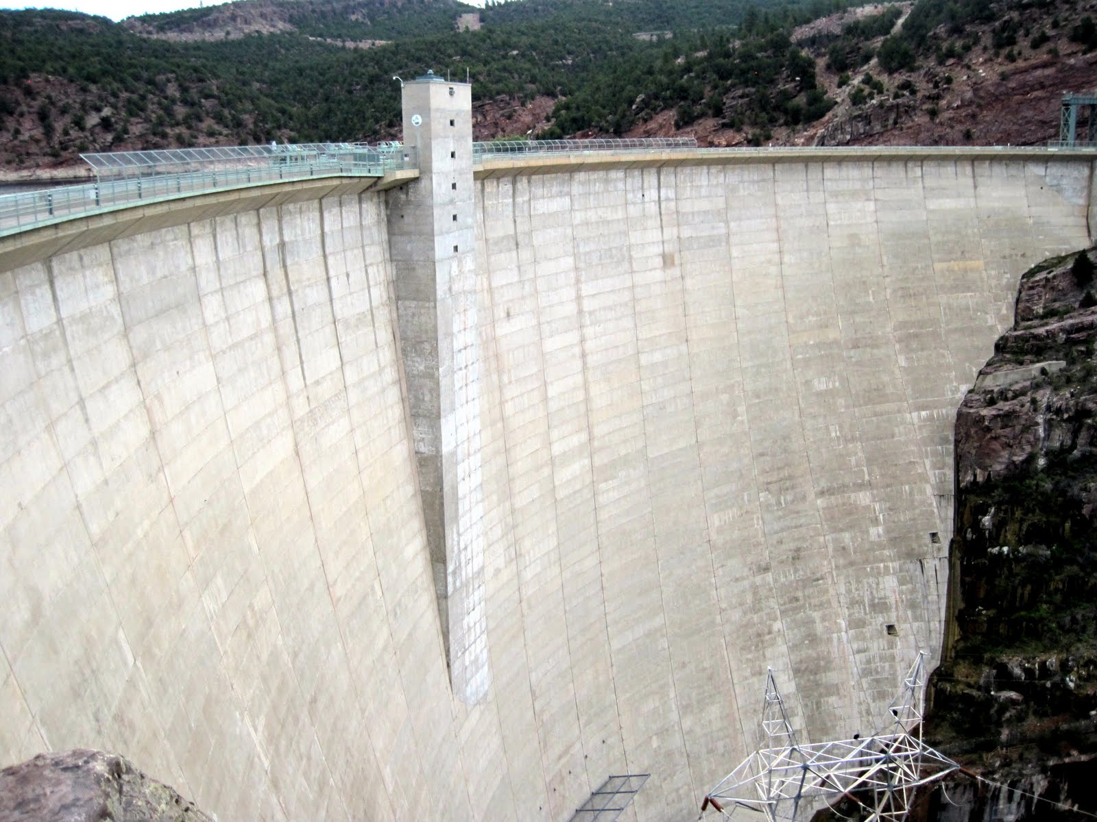 |
| Flaming Gorge Dam |
 |
| Turkey vulture! |
Decided to stop at the Visitor
Center right there are the dam and explore more – including a tour down into
the dam itself! There are huge birds
soaring everywhere and we eventually learn they are turkey vultures. We see an array of them perched on the
electric towers during the tour. Flaming
Gorge dam is nearly 500’ high, with a concrete arched construction similar to
Hoover Dam. We take an elevator down to
the bottom level and the turbines and generators. Then out to feed the fish that congregate at
the water outlets – this is one of the best fishing rivers in the country.
 |
| Aspen trees! |
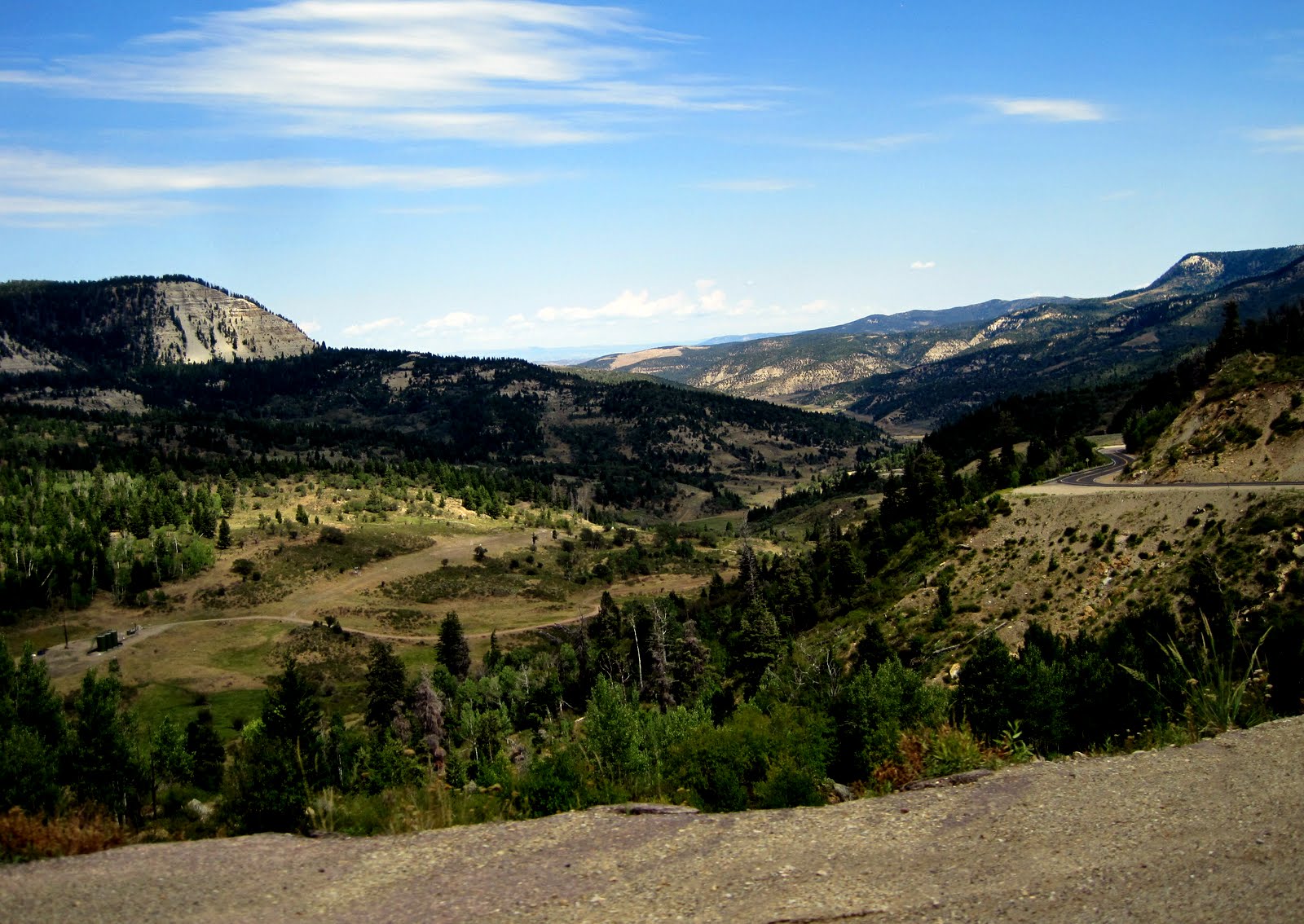
From Flaming Gorge we climb, and
climb – up to the junction with the west side road and then we climb some more….eventually
to an 8400’ pass. Poor Honda, but the
truck plods along great. The west side
of the gorge is much greener with more pines and aspens. At the top of the summit, there are groves
upon groves of aspen trees. A nature
walk through the aspens was also available, but at this point we needed to keep moving! We spent nearly an hour and half at the
dam!
And then, we see a sign indicating
an 8% downhill grade for the next 9 miles of sharp hairpin turns and
switchbacks! Oh boy. At one point Rick has the truck down in first
gear to lay off the brakes. And going
that slow wasn’t too bad since some of the curves said 20 mph!! It was a bear, but at least Ouray won’t seem
so bad now!
 |
| Vernal KOA campsite |
We pulled into the Vernal KOA
around 4:15 amidst a heavy wind storm, dark clouds, and occasional drops of
rain. But nothing more really
developed. We got the trailer set up
except for the back bed – decided to make sure no rain was coming first.
Rick took a short run and then we
both hit the swimming pool for a little cool off and exercise(no danger of lightning
anymore) and then dinner time!
Our special meal is always sourdough bread, crab, cheese, and a bottle
of wine. It tastes great! I couldn’t get the “fancy cheese” I wanted so
I went with “his and hers” cheeses – pepper jack for Rick and Swiss for
me! We’re both happy!
Quiet evening of a little Olympics
on TV and catchup on the computer. Rick
drove all the way today, so he deserves to be a little tired. And some of that road wasn’t the easiest
driving with the trailer!
Saturday, August 11, 2012
 On the road
east on 50 to Black Canyon of the Gunnison National Park, just 20 minutes drive
from the RV Park, but….UP again!!
Fortunately this time the truck is NOT pulling the trailer as we climb
2500 feet again to the top of the mesa.
On the road
east on 50 to Black Canyon of the Gunnison National Park, just 20 minutes drive
from the RV Park, but….UP again!!
Fortunately this time the truck is NOT pulling the trailer as we climb
2500 feet again to the top of the mesa.

Saturday, August 11, 2012
 |
| Vernal flowers |
Whew! An eventful day of four major
happenings! We left the Vernal KOA just
after 8am, as we waited to pick up a few items we saw in the gift shop and we’d
forgotten to go before they closed the night before. Through Vernal to find a gas station,
eventually arriving at a Maverick underselling everyone else by at least 5
cents! Vernal is gorgeous with petunias –
all in white, pink, and purple. Hanging
baskets, sidewalk baskets – all overflowing.
I have never seen anything like it.
Smooth
drive east on 40 to the Colorado border and we head down to Rangely. So far, so good. Around 9:30, just after turning south on 139
to cut down a “black highway” to the interstate 72 miles away, we hear and
clanky clank clank of metal. Rick quickly
pulls over and we find the propane tank, still attached by the hoses, on the
road. Oh dear. Rick turns off the propane. We smell a little leakage and he finds a
small crack in one of the connectors. We
also have to improvise with the tablecloth bungees to hold the tank in place
long enough to return to Rangely. After
checking a couple places, we are sent to the Ace Hardware Store. In this case, “Ace was the place with the
helpful hardware man…named Roger”. For
$15, Roger fixed us up with a new connector, new screws, lock washers, and wing-nuts
to re-secure the tank to its mount (obviously we had lost the other screws – we
think the bumpy road loosen them), and to purchase three bungees for added
security. We lost about an hour and a
half, and a good deal of stress! But,
all fixed up!
 |
| View back down canyon from Douglas Pass |
Midway
between Rangely and Loma we had to go over the 8200’ Douglas Pass. It proved more formidable than yesterday’s
summit as the road was in much worse condition.
Very bumpy. A long drop down the
south side of the pass with steep hairpin turns. More tough driving for Rick.
 |
| Near entry to Colorado National Monument |
We have two
major stops today, both involving National Parks. Near the Interstate 70 junction and the town
of Fruita is the Colorado National Monument – a 23 mile rimrock drive through
spectacular rock formations, 3 tunnels, and some serious elevation
changes. We find the Visitor Center is 4
miles up from the entrance station, key word being UP! Again, Honda has to work to pull the trailer
up to the top of the mesa. At this point
we decide we’ve done the worst of the up, we might as well drive with the
trailer through the park and end up in Grand Junction where we want to be
anyway!
 |
| Add caption |
Since most
of the views were going to be on the driver’s side going in the west to east
direction, I opted to sit right behind Rick so I could take pictures out the
window. Already a bit behind schedule,
we didn’t plan to stop at the pull-outs which was a good decision – there was
no place to park a trailer at any of them anyway! So my pictures are ALL from the window of the
truck as we were on the move! The
descent down into GJ was also filled with hairpin 15 mph turns. Agh!!
Finally,
after gassing up in GJ, we are enroute to Montrose and our Cedar Creek RV
Park. We hope to get to the Black Canyon
National Park visitor center before they close at 6 pm (so I can get my
Passport stamped!) The road from GJ to
Montrose is a steady climb, the stretch from Delta to Montrose much more
interesting with mountain ranges appearing in the distance and GREEN!
We get set
up at our campsite – first time to have cable TV and we probably won’t even be
here much to enjoy it! (Later find out
we didn’t connect very well for some reason, but by then Rick was too tired to
figure it out and went to bed!)
 |
| Black Canyon of the Gunnison |
 On the road
east on 50 to Black Canyon of the Gunnison National Park, just 20 minutes drive
from the RV Park, but….UP again!!
Fortunately this time the truck is NOT pulling the trailer as we climb
2500 feet again to the top of the mesa.
On the road
east on 50 to Black Canyon of the Gunnison National Park, just 20 minutes drive
from the RV Park, but….UP again!!
Fortunately this time the truck is NOT pulling the trailer as we climb
2500 feet again to the top of the mesa.
From all the
horizontal strata of Colorado National Monument, the Black Canyon is marked
with vertical dykes and plugs all over the place. Little red rock, and mostly volcanic gniss,
granite, and black rocks. The canyon is
extremely narrow, like a huge crack in the ground. The Gunnison River has carved it out due to
the extreme volume of water which drops more feet in elevation in its 20 miles
than the Mississippi does in 1500! An
amazing site. Rick wanted to drive down
to the Portal Entrance, where the diversion channel brings the waters of the
Gunnison to Montrose and beyond, but the 7 mile drive was marked by 16% grades
and he decided the Honda brakes had had enough of a workout today! We drop most of the rim drive, stopping to
take many of the short hikes out to the viewpoints. A beautiful evening. We ate a picnic dinner at Pulpit Rock.

Home to the
trailer amid a lightning storm in the distance and a spectacular sunset. I took over 330 pictures today, so the rest
of the evening is spent downloading, uploading, and editing and writing herein
very quickly!! Goodnight!


Sunday, August 12, 2012
Our last
day of travel and we are excited because it is a mountain day!! Up and out of Cedar Creek RV Park, sorry we
didn’t get a chance to take advantage of the mini golf (it was even free!) or
walk along the creek. But we had a great
time at Black Canyon instead.
 |
| From Ridgeway we are headed up this notch. |
Gas,
coffee, and we are on our way. Only 170
miles to Pagosa Springs, but several mountain passes, including one at 11,000
feet. This is a spectacular drive
through the heart of the San Juan Mountains, 13,000 and 14,000 foot peaks,
aspen groves, and years of mining memorabilia.
First stop
is Ridgeway, a gateway town and also a junction making possible a loop road
trip through the mountains. Then just 11
miles to Ouray. We have never approached
Ouray from the north and it suddenly comes up at you. Much different than when you dropped down on
it out of the sky! The main street
slopes to the west. We didn’t stop, as
Rick wanted to get up and over the worst of the road early on this Sunday
morning before traffic picked up. We can
come back over with just the truck later if we choose.
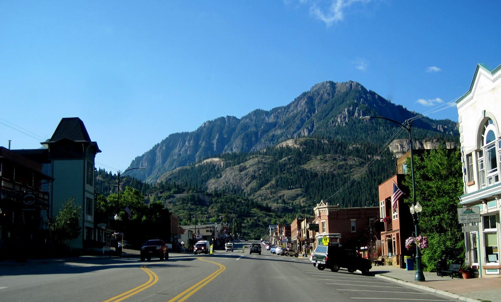 |
| Sloped Main Street of Ouray, CO |
 |
| Red Mountain of Red Mt. Pass fame |
The first
six miles out of Ouray are literally the Million Dollar highway, even though
everyone uses the term for the whole 82 mile route from Ouray to Durango. This section has literally been carved, S
turn by S turn out of the hillside. It
is steep, sharp, and spectacular…..if you are not the one driving!!! Rick said he would look at the pictures
tonight to know what he saw today!
Mostly he had to concentrate on keeping the trailer and truck on the narrow
road (without much of a berm or guardrail and steep drop-offs), whether to
downshift to gear one or two, brake or not to brake, etc. etc. Exhausting work for him!
I, on the
other hand, took pictures from the windows of the truck. All of our pictures today of the mountains
were taken on the move! I don’t know the
names of most of the peaks or passes, but I know the sky was blue and the
clouds puffy white, the peaks an array of grays, blacks, reds, and browns, and
the hillsides covered with aspens, spruce, pines, and firs. Everything was so green. (Fire danger is low in this area right
now!)
 |
| A hillside of aspen trees! |
 |
| Catholic Church in Silverton |
 |
| I loved the old fashioned teller windows at the bank! |
We stopped
in Silverton to stretch our legs. Walked
around the back streets and then Main Street.
Found three little churches to photograph (that was my worship for
today!) and the shrine up on the hillside that the Miners built to Christ. The county courthouse and city hall are gorgeous
old buildings. We were impressed overall
with the Victorian charm and decorations on many of the houses – and a liberal
use of the full spectrum of paint colors!
Stopped along Main Street for an ice cream cone. I think it will be lunch!
Gradually
our blue skies are filling with clouds and by the time we reach Durango, we
have even felt a few drops of rain. Off
and on, and nothing too intense. We only
saw one flash of lightning all afternoon.
We gas up in Durango as we have heard that prices are nearly 15 cents
higher in Pagosa Springs. It should last
for a little bit anyway!
 |
| Our new Pagosa Springs 'home' for the next month. |
Last leg of
our journey down – 62 miles to Pagosa Springs from Durango. High elevation rolling hills, with more and
more forested areas coming into view. We
stop at the main shopping area, which is about 3 miles WEST of town, then a
visit to the Visitor Center to pick up some Monday reading material, and
finally a drive through town and on out to the east about 5 miles to Elk
Meadows Resort – our home for the next month.
Nancy, the
owner who I spoke with on the phone is not available, but another guy finds
where we are to be on the map, and helps us locate our spot. We get settled in and meet Barb and Mike
Smith from near Phoenix, AZ, who are also part of the Habitat group and camped
next to us. This is their second build,
as they came up to Pagosa last summer also.
(Anything to get away from the heat of Phoenix, Mike said!)
After three
tries, I give up trying to find Nancy in the office. I get the internet code from Mike so I can
get started on-line. Nancy can come find
us if she wants any money! Cell phone
coverage is going to be hit or miss, mostly miss. I did get through to both boys, but couldn’t
send a text to them. Couldn’t get
through to moms. Will have to use this
great internet connection for most of our communication.
 |
| Hummingbirds! |
Rick and I
have an early dinner and Rick spends a bit of time in conversation with Mike
while I start downloading pictures for the day.
Then a walk down to the river where we see a deer, a hobo camp (not
really, but it is an odd collection of very old campfires, benches, chairs, and
tables.) A beautiful sky as the sun gets
ready to set. Enroute back we pass a
camp where there are four hummingbird feeders set up (a rather permament
home). There must be 20-25 hummingbirds
zooming around and drinking. They flew
right up to our chests to “check us out”.
Unnerving yet so cool.
The
crickets are chirping, the traffic on the highway is dying down (we are only
100 feet away at best) and the night is cooling off. A great start to a new experience. G’night.
More mountain pictures from today.....or you can click HERE to see all of today's pictures!


No comments:
Post a Comment