SOUTHWEST SPRING SOJOURN 2022
Thursday, March 24
High Country Homestead to Springville, UT
522 miles

the Boise airport for her 12:10 flight back to Sacramento.
Elkhorns are topped with clouds, but the day grows clearer and clearer as we leave Baker Valley and cross Idaho. And it gets warmer and warmer! Midway through Idaho we have to open the windows a little for some fresh air!
We leave the Boise airport around 10:40, then stop in Mountain Home to gas up and switch drivers. I can’t remember the last time I drove the truck with the popup trailer – maybe in 2013!? But you hardly know it is back there, unlike the bigger trailer.
We stop just past the interstate Y for I86 to go on to Pocatello at a rest stop to grab a bite to eat. I then continue to drive into Utah, past Snowville and Tremonton and into Brigham City. A gas stop and then Rick gets the ‘pleasure’ of the Salt Lake City corridor for 95 miles until Springville south of Provo.
And it is definitely NOT a pleasure! We hit this stretch around 3:30 and the traffic just gets worse and worse until about 10 miles before our exit! If it weren't for the views of the Wasatch Mts........ But...Rick perseveres and we arrive safely around 5:15 at the Days Inn.
A short mile walk around the area before we settle into the room for the night. I finish last night’s crab salad while Rick dines on cheese, chips, and carrots and hummus. It works!
I have tried calling Lester, but the line is busy. Sent a text, hoping his phone gets texts! AND sent Annette an email!
The Wasatch Mountains are gorgeous in the late afternoon sunshine!
 |
| Right from the middle of Salt Lake City |
 |
| Nearing our stay for the night in Provo |
 |
| Hard to keep your eyes on the road at times! |
Friday March 25
Springville, UT to Cortez, CO
301 miles
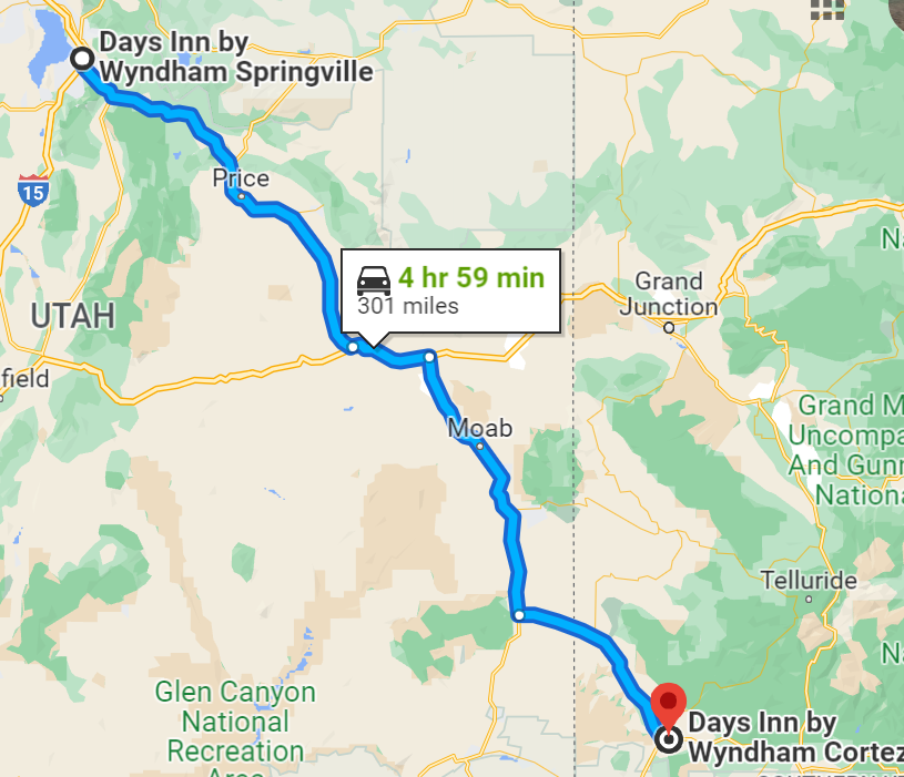
We have a rather relaxed morning as it is a short day – thankfully, after a long one yesterday – and a relatively short drive down to Cortez. Enjoy our breakfast (waffle pickings only really, so we have cold cereal!) and then on the road around 9. It is a beautiful day – and forecast for a warm one for Spring!
We bid goodbye to the Wasatch range and enter the canyon – still pretty much brown and patches of snow! But this is always a pretty drive over the pass to Price. However, that sun is in our eyes!

Moab is a ZOO!! We drive through as quickly as we can!
Into Cortez around 2pm and get set up at the Days Inn there at the east end of town. Time for a walk! We wander toward town and end up in the Walmart, picking up a couple of birthday cards for the boys.
Next
to the hotel is a Mexican restaurant and that is sounding pretty
good! We end up splitting a Queso Fundido, plus a beer for Rick and
a sangria for me – a sangria
that looks very fancy and when we get
the bill discover it cost $9!! Ouch! Oh well!
While in the restaurant I get an email from Annette – it is not going to work out to meet with Lester. :( So, we change plans to cut straight down from Durango to Luke’s and drop off the trailer there. His news is that the boys will only be at Randy’s on Saturday, so we will head out as soon as we can get there.
Quiet evening otherwise and early to bed!
 |
| Leaving the hotel Friday morning |
 |
| Wind farm at the entrance to the Price Route 6 canyon out of Springerville |
 |
| Cliffs near Price UT |
 |
| Found a window in the rocks! |
Saturday March 26
Cortez, CO to Albuquerque, NM
255 miles
We are up around 6:45 – a restless night for us both! - and by 7:25 pulling out of Cortez. Breakfast was ‘Grab and Go’, so Rick found some Little Debbie’s chocolate donuts – a happy man!
 |
| Mesa Verde NP mountain in the morning sun |

procession as they are all in a row even spaced and no one trying to pass. And then….they all turned off on a road which we think headed down to Chaco Canyon. Is there a protest going on for the oil drilling?
Rick takes over the last shift in Cuba and we pull into Luke’s just a couple minutes before noon. Unhitch, unload a little, and by 1pm we are headed east, all packed into Luke’s car, for the drive out to Randy’s.
A fun, slightly chaotic, afternoon with the boys – plenty of trampoline time, hide and seek, pizza and homemade chocolate chip cookies! The boys leave around 5 to head out to Grandma Nicky’s and then we play games for about 3 hours! Great fun with 7 of us around the table. Rick and Randy have some good conversation time.
Home by 9pm and into bed shortly after 10!
 |
| Extra! Charlie FINALLY decides I am ok and lets me pet him! |
 |
| Jed and Jaxon and West on the trampoline |
 |
| Rachael, Ryan, and Patty |
I took more picture than this, but somehow my camera and Google Photos lost them all. Bummer.
Sunday March 27
ABQ – BBQ and Campfire
 |
| Luke checks out at guitars, etc. at the yard sale |
mariachi bands. He has to order strings, but it will be a fun addition to his stringed instruments.
What else did we do? We didn’t go to church! I went shopping with Luke and Kady to pick up a few supplies for the YAV project on Monday – that included a trip to Costco! Jed navigated Rick up to Regan’s barber shop so Rick could get a haircut early afternoon.
Late afternoon Jed, Luke, and I walked over to the nearby neighborhood park and played bocce ball. Luke killed both Jed and I but I did score a few points!
Sunday evening we BBQ’d “Beyond Burgers” (vegetarian and very good) and then later had a campfire out back and enjoyed s’mores and a visit from Lindsey, Jed’s former Socorro roommate.
 |
| My best scoring ball in bocce... I was pink! |
 |
| Lindsey brought over GIANT square marshmallows. A challenge to place on s'more one handed! |
 |
| One of Luke's campfire pictures |
 |
| Jed and Lindsey |
Monday, March 28
ABQ - YAV Glass Etching
Luke and Kady have to go back to work today! But Luke’s work also involves us! After a quick visit to Walmart for contact paper, we drive down to the YAV house for a Glass Etching session! Unfortunately Peter is still in NC following his grandfather’s memorial service, so it is just Savannah and Emma….and the 12 dishes that Luke wants etched with roadrunners!
Jed tackles the roadrunner dishes, altho eventually it is an assembly line as I trace the patterns on to the contact paper, then Rick and Jed are cutting out the stencils, and Luke is the master of the etching cream in the laundry room. The girls had a blast making some of their own designs. I eventually leave the basic materials for them to finish up at their leisure (or buy more glass!) Jed leaves at 12:30 to have lunch with Lindsey, while Rick and I enjoyed a wonderful lunch prepared by Emma out under the patio table umbrella out back.
Rick and I head out around 1:45 so Luke and the gals can get to work on their raised bed project in the back yard. (Mondays are Community Days in the YAV house) We find Jed already back at Luke’s when we return. Then a relaxed

afternoon as Jed finishes up some school work, and then we play a game of ‘What’s Your Point?’ before Luke leaves to teach a group tennis lesson and we take Jed to the airport to fly back to Salem.
Dinner is catch as catch can!
Rick and I move from Luke and Kady’s room into the guest room where Jed was sleeping. They had been on a portable mattress down in the den.
 |
| Explaining the etching process to Emma and Savannah |
 |
| Applying the cream and rinsing in the laundry room |
 |
| Emma serves up a yummy lunch! |
 |
| Starting work on their raised beds. We left! |
Tuesday, March 29
ABQ – Old Town
 |
| Clay nativity I wanted to remember! |
 |
| Luke tries to move the birdhouse as the wind kept blowing it into the window. |
Luke and Kady both home around 3pm. Afternoon doing laundry, playing a game of Trash Panda Trash, and dining on BLTs SW style (eg, with chili peppers included and guac!) Kady had one of her education classes during dinner, so she joined us when class was over.
We also took the time to go through the trailer and remind Luke of its quirks and operation. I think they are excited to take it out, but have to get it licensed, and the electric hookup to Kady’s rig refined (it only partially worked!)
 |
| A new fun game! |
WEDNESDAY March 30
ABQ – Breakfast and Walk
We had a text from Randy last night that they had to be in town early this morning for a doctor appointment on the west side of the city. Would we like to meet for breakfast? Well, YES! Kady left VERY early for a Spin Exercise class and work, but Luke was able to join us for breakfast at Tia B’s Waffletia – all things waffles – both sweet and savory! Rick and Luke veered more toward the SW carne asada style, Patty had biscuits and gravy waffle, and I had a sausage biscuit with cabacinitas (squash) and avocado! Randy went sweet – VERY sweet!
 |
| Probably not our best photos, although Randy looks pretty excited! |
After
breakfast and a second round of goodbye hugs, we head over to a
distributor to pick up beers for the boys and Rick, then drop Luke
off at work.
Around 11:30, Rick and I take off on a walk – I knew it was going to be a little longer than I wanted, but it ended up 5.3 miles!! I’ll feel it tomorrow as it was all on concrete sidewalks! And it started raining again right as we walked out the front door! Glad I put on my heavier hooded sweatshirt, so the rain didn’t really bother. We had some breaks along the way and a little sunshine at times! It is a LONG stretch along Gibson Avenue and Kirkland AFB!
 |
| My feet were sore after the walk, so Luke gave me a massage and then a warm soak! |
Dinner is Naruto Noodles, the place Jed ate at on Monday with Lindsey. We order by phone and then Luke and Kady go to pick it up. More fun things to try! Spite and Malice games until 10, then time to crash!
 |
| A fun new entre for Rick! |
 |
| Ricks dinner |
THURSDAY March 31
ABQ to Ruidoso, NM via Bosque del Apache Wildlife Sanctuary
199 miles

had two tennis lessons this morning. Luke and Kady will take off around 3 this afternoon after they get off work.
The weather is much nicer than yesterday with the skies filled with puffy clouds on the horizons and stretched out clouds high overhead! We stop in San Antonio and eat at the Owl Cafe, world famous for its green chili cheeseburgers! A fun place with owl art everywhere, paintings to metal works to string art. On the walls people pin up dollar bills – over the years the cafe has donated the money (to the tune of $35,000) to various charities, especially those concentrated on children. Last year was $1800 collected off the walls. We stuck up a dollar!
 |
| Lots of owls decorate the walls of the cafe! |
 |
| Money pinned to the walls all goes to charity. |
 |
| The Owl Cafe |
Then on down the road to Bosque del Apache preserve. The visitor center was closed and we didn’t see the big birds as it is too early in the migration season (or too late!) But we enjoyed the arboretum, where over a 100 species of cactus and desert plants are identified. That area was also a cacophony of bird music.


We drove the north loop road which goes around one of the large ponds – earlier this month they prescribe burned a section to help restore the natural vegetation. It was interesting to see and read about the way they maintain the landscape here along the Rio Grande.


Finally
around 1:45 we are ready to head east on Rt 380 tow
ard Carrizozo and
the Lincoln National Forest and Ruidoso. Wide open skies and plateau
country. Just south of us is where the atomic bomb was tested at the
Trinity Site. Just west of Carrizozo we passed
through the Valley of Fire Recreation area which is basically a thick
lava bed strip about 3-4 miles wide and 20 miles long.
 |
| Love New Mexico skies and clouds! |
We are a little disappointed. The cabin is a single wide mobile home in which attempts to upgrade have been made, but not always in very aesthetic ways. The dishes in the washer still have some dirt on them. For all the ‘rules’ we were given, we expected a little more quality. I find dirty foil with food remains in the oven when I go to put in the pizzas.
 |
| Deer frequent the yard around the cabin |
 |
| Quick view of VRBO accommodations |
 |
| Back deck with hot tub! |

On the plus side, there is a working hot tub that appears to be in relatively good shape. An abundance of deer wandering just below the deck. Some games and plenty of books.
Luke and Kady arrive around 5:45 – before I had the first pizza cooked! And the oven appeared to struggle. I think Rick finally finished his off in the microwave! But we got it done! Evening reading through literature, playing games, hot tubbing, and I started a puzzle!
FRIDAY April 1, 2022
Ruidoso: Grindstone Lake Trails and Apache Ski Road
44 miles
A lazy morning! Kady slept late after a restless night – she and Luke had some mattress issues! Otherwise we enjoyed a quiet morning with Pinon Fudge coffee and chocolate donut holes and other good stuff!
Then we head out in the truck for Grindstone Lake and the trails surrounding. A dammed lake that is pretty low at the moment, the winter snows having not been up to par. We wander along the trail that borders the lake up on the hillside. Lots of alligator bark juniper and scrub oak that still has its dead leaves. And pines. Lots of pines. On the far side of the lake we finally get some views of Sierra Blanca peak (just over 11,000’) which still has snow on it. We can’t get across the dam so we wander below and find the 27 hole frisbee golf course – and there are some LONG holes. This isn’t a course for beginners!
The lake is a mecca in the summer time with a swimming area and it boosts a floating waterpark in the summer months. Several families out fishing today.

 |
| Wild horses! |
 |
| Alligator Juniper tree |


And then we need to explore the peak, so we head up to Alto and find the road to the Apache Ski area (one of the only ones totally owned and run by Native Americans – the Mescalero Apaches) Twelve miles of winding hairpin road that climbs and climbs! Early on we passed a herd of wild horses grazing by the road. Pretty cool. The area is known for a number of ‘feral’ horses. We stopped and got out at Windy Point View and could hardly open the truck doors on the passenger side it was blowing so much! But great views out over the land. We could see the Lookout to the NE and still not sure if we will venture there or not.
We dropped over a ridge and into the ski area proper, but it is closed between seasons right now, so we couldn’t go in further. :( In the summer it has bike trails, an 8 passenger gondola to the top, and one of the longest zip lines in the world at over a mile and a half.


DOWN DOWN and back into Ruidoso and the Albertsons to pick up dinner, which we all decide will quickly be eaten once back at the cabin! Chicken and tater salad, garlic bread! It is devoured!
Rest of day spent in the hot tub (twice), games of Catan and Shut the Box and Ravine, and feeding the deer! We gave them some leftover carrots, but they really perked up at the deer pellets we found in a garbage can out back. The time spent in the hot tub at night was gorgeous – clear skies and STARS! Luke had his phone out IN THE TUB to use the Star Gazer App and help identify constellations. The hot tub has different colored lights and little fountains – fun stuff!
A good day together!
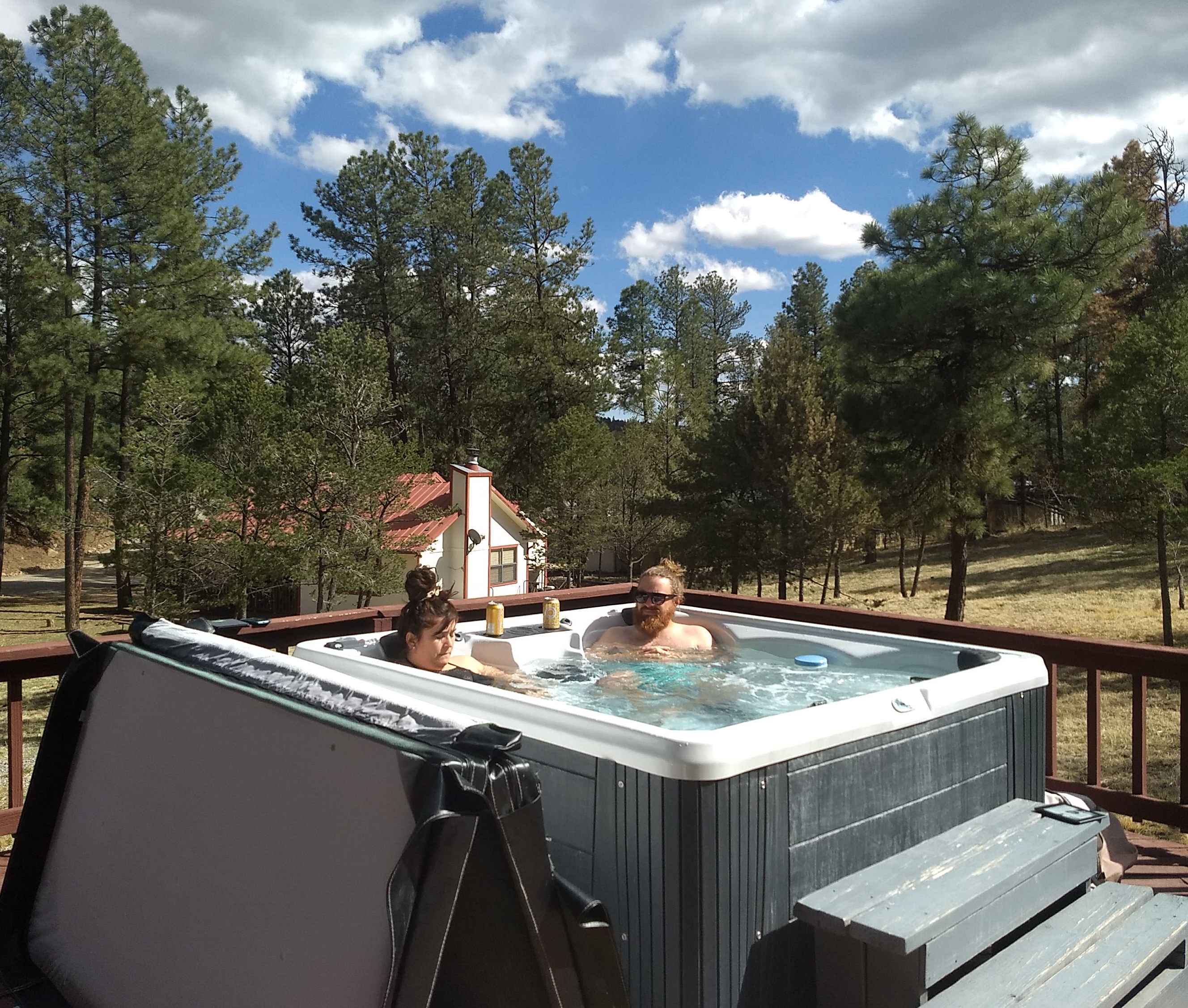 |
| A little hot tub fun |
 |
| We fed the deer HEALTHY foods! |


SATURDAY APRIL 2
Cedar Creek Trails & Downtown
Another beautiful day – forecast even warmer than yesterday! We head up to Cedar Creek and the trail network through the Ponderosa pine and juniper forest (with more Douglas fir trees than expected!) Along the way we finally saw some elk grazing right next to some houses.
We end up hiking about 3 miles, seeing some deer and a horny lizard that scurried across the trail. Otherwise his camouflage was so good we never would have spotted him. The creek was mostly a grassy bog – very little water, but enough to make the grass green in the channel. A few places had little ponds and in one we found some ducks.

 |
| Can you spot the horny lizard? |

 |
| Loved these signs at many trail entrances! |
Back down the road into the ‘downtown’ sector...Luke is once again hungry so we find the Hidden Taproom – a little pub located under one of the main street shops. Beers and blueberry cider all around and some chicken tenders (Rick and I shared). Then we are off to poke around the shops.
Downtown is CROWDED!! And probably one out of every two cars is from Texas, if not more. Ultimately we explore the Mountain Arts Gallery where Rick and I pick up a gift for Luke and Kady and the gal frames an aspen print for us. All very reasonably priced. We grab a couple of t-shirts in another spot and all decide it is time to head back to the cabin! (After another stop at the Albertsons for more water and food for dinner and Canyon de Chelley!)

I get my Crossroads summer classes planned out, Luke, Kady and I play a few more games, and eventually around 8 we head back out to the hot tub – another beautiful evening under the stars. Luke brings out his ‘fancy’ camera to take pictures. He also watches the end of the Duke-NC Semi final BB game on his phone while in the hot tub!
Last night at the cabin!
SUNDAY April 3
Ruidoso, NM to Clifton, AZ via White Sand National Park
311 miles

cars are packed, and we ready to roll! Luke and Kady hope to drive down to the Inn of the Mountain Gods before heading back up to ABQ. Rick and I have to find a garbage dumpster and then we are off westward on US 70 toward Tularosa and Las Cruces.
Up and over a summit and then down down down to the Tularosa Basin and Alamagordo. We wind our way through Alamagordo, staying on 70 toward Las Cruces and on out to White Sands, which has changed from a National Monument to a National Park since our last visit. We take in the Visitor Center and then head out the scenic road which penetrates 8 miles into the dunes. The place is crawling with people on a day forecast for a high of 80 (and the ranger says a humidity of 8%!) Take water! But we are mostly along for the drive, with a short stop to take off our shoes and wander out into the dunes for abit. Fun watching kids try to sled down the dune hills. Lots of picnickers out for the day.


On down toward Las Cruces with increasing views of the Organ Mountains – I love the rocky pillars of these mountains. A stop in Cruces for a cold drink and we switch drivers.
 |
| Organ Mountains from the east side |
I take us across the flats toward Deming, NM. We haven’t traveled this section very often, especially heading west. No loss, as it really isn’t very interesting! Rick drives us from Deming to Lordsburg where we stop cause I need to go! (So we tank up again because it appears to be the cheapest we will see the rest of the trip!)
In Lordsburg, we continue on US 70 northwest toward the Arizona border and the mining towns along the Gila and San Francisco Rivers. Destination – Clifton, the location of one of the largest copper mines in North America (the actual mine is in Morenci – 2 miles up the road and at the top of the plateau)
What a step back in time! Clifton is set along the San Francisco River, which had a major flood in 1983. Our hotel was actually underwater for the first floor. Brick walls, some plastered over, but much brick and stone showing. Vintage OLD! I am sitting as I write in a little ‘common area’ for the first floor rooms. When we get here, we are greeted by a friendly dog, but can’t locate a ‘front desk’ and the bar next door is closed. But as we come back into the hotel entrance, the owner greets us and shows us our room. There is only one other room occupied tonight! She also tells us to head up into Morenci for a grocery store and a possible place to eat.
 |
| Cliff workers while we are stopped in Clifton |
 |
| Clifton Hotel from the park across the road |
So...up the highway just around a big hairpin curve and we find the ‘plaza’ in Morenci, a town that has been upgraded a great deal by Copper money in recent years. A large grocery store – more water and some frozen microwave dinners for tonight!
We eat in the common room of the hotel and then I suggest a short walk to stretch our legs….Ended up an hour and a half because people in Clifton are VERY friendly....and I guess we stick out like 'tourists' big time!
First we ran into a old Navy veteran who has been here for 40 years and was editor of the town newspaper for much of that time. He was just enjoying chewing the fat while his wife was over in the community garden. Told us all sorts of back history and answered some questions. Then a lady out watering the plants in front of a neat old building spoke to us and asked if we were visiting. She recently retired here from LA about 5-6 years ago and LOVES IT! Apparently the building was the former Presbyterian church turned Masonic Lodge, and she has turned it into the Blue Door Sanctuary and hosts events - the chancel area becomes a mini stage for vocal groups! Plus she is REALLY into mosaics and showed me all over what she has done. We got the full tour when Rick told her I was a Presby PK!

 |
| Blue Door church - now private residence and meeting hall |
 |
| Giant mill machine |
Our route tomorrow will be interesting! Have to get an early start as the 75 miles of 191 toward Alpine is reputed to take 3 hours if you are driving carefully! Oh boy!
Back into Arizona and standard time (they don’t observe daylight time) so we set the clocks back an hour….which proved to be a mistake tomorrow.


MONDAY APRIL 4
Clifton, AZ to Canyon de Chelley NM
285 miles

What a day! I sit in the dark in the truck hoping to at least get some of the day’s events down before retiring to our ‘hogan’ for the night.
A somewhat restless night in the hotel, altho the bed was comfy, etc. I kinked my right shoulder blade at some point yesterday and just couldn’t get comfortable. Early morning saw some better sleep, but I got up at 6:15 (as usual) and went out to the common room to draw my prayers, Quordle and Wordle, and play a few rounds of solitaire! Made some coffee in the kerig machine.
But Rick and I are on our way shortly after 9. Our first big visit was to drive through the Morenci Copper Mine, the largest open pit copper mine in North America – spanning some 80 square miles! We just kept winding up and up out of the canyon past layer upon layer of mountain side rock. An outstanding interpretive site looking down into the active pit. The upper viewpoint was none other than one of the dump truck buckets...and a display of the tires used which are the equivalent of 400 regular car tires. Massive in scale all around.


And then it is some 70 miles into Alpine – winding in and around, up and down – the road marked with a multitude of yellow arrow signs and 15mph curve signs! For the first 50 miles I would say we encountered 2 trucks and a motorcycle going the opposite direction, and three motorcycles passed us. As we neared Alpine, traffic was heavier.
We went through juniper forests, then ponderosa pine forests, along ridges, and mountainsides with views to the west especially down to Mt. Graham and to the east to the Mongollon Peak and White Mt Peak in the Gila of New Mexico. A middle stretch of grazing land and lots of grass. Near the north end we stopped at a viewpoint and it began to slushy snow on us – very light, but after getting back on the road it rained/slushed heavier for a short bit. And all through the final 30 miles we encountered the remains of multiple wildfires – some that were ground burns that left the ponderosa pines alive, others that torched whole hillsides and left towers of black.

 |
| We spotted these 'bears' peeking out from a cave |


From Alpine north, through Springerville and St. John’s to the freeway, the highway passed through tracts of grassland, sage, and scattered junipers. A vast EMPTY stretch of land!
We gassed up at the freeway in S…. for $4.35, not sure where the next gas would be available and for what price. I couldn’t get anything on my phone. A short 6 miles on I-40 west, and then back on US 191 north. Quick conversation while I had service with Jed and Liz and got a text off to Karen and Rob (Rick had missed a call on Sunday). Then out of coverage again!
More wide open spaces as we drive through the southern section of the Navajo Nation lands (and a few gas stations for $4.25!!) After Ganado we start seeing rock formations and mesas again, arriving in Chinle around 3:45pm …. which, when we arrived at the Canyon de Chelly Visitor Center at 4:02 and find it closed at 5, we remember the Navajo nation does observe Daylight Time and it is an hour later than we thought! So….watches back ahead, except my Fitbit won’t sync because it is off-line. My phone did, however, reconnect to US Cellular and changed! How confusing!
We drive out the south canyon road toward the end of pavement and our stop for the night at Spider Rock Campground. Wow. Oh wow. Howard, the owner, comes out to greet us – so laid back. He had been in town doing his laundry, so says he needs to get the hogan ready. Do we want to drive out and see Spider Rock in the meantime? Sure, we say. Another 4 miles out the road, but well worth it for the lowering sun on the canyon and the 800’ rock tower in the center. We see some old cliff ruins across the way. The bottom of the canyon is green and fairly lush looking. We never do quite ascertain what is Spider Rock – guess it is the columns!
 |
| Spider Rock columns |

Back to the campground, although we drove right past it and two miles later realized our mistake! We check out the hogan. It is…..primitive to say the least. Patched up with tarps on the SW side (winds blew much off two weeks ago) – a double mattress low to the ground (but off it!) and a single, plus a small table and chair tucked into a corner (and largely inaccessible) and a little wood stove. The oil lamp has no wick. Howard sells us a bundle of wood for the stove which turns out to be enough for about an hour or two of heat! Dirt floor. We discuss our options and decide to just stay the one night, try for a tour in the morning, check out the VC, and then head on in to Chinle or Bluff for the night. Howard gives us the phone number for a couple of tour folks and Rick calls a couple times before getting through and making arrangements for a 9am tour tomorrow morning. It will cost $175 but is a unique opportunity with a native Navajo guide on the canyon floor.
 |
| Our hogan accommodations...primitive to say the least |

Finally pull out some ham, cheese, and carrots for a much needed meal of sustenance. Rick is tired! It was not easy driving today!
A bit of a sunset and then the skies turn dark and the stars come out. A sliver of a moon. Think I will head in and see what the night brings!


 |
| This is a photo of the 'single' person hogan! |


TUESDAY APRIL 5
JEEP TOUR of Canyon de Chelly
Spider Rock CG to Bluff, UT
109 miles

took me an hour to finally conk out, and then lots of tossing and turning, but I think I slept more than imagined!
Up around 6:45 when the call of nature finally overruled staying in my sleeping bag. Walked around the camp for abit and then into the truck to watch the sun rise, do a couple Sudokus, and write. Will be time to rouse Rick shortly. More later….

 |
| Juniper berries abound on the trees |
We leave the campground around 8:15 and drive back down the south rim road to the visitor center. Quick bite to eat and the restroom, and we identify our tour guide in his white bronco. Ben is a Navajo elder – born in September of 1938, which makes him at 83 the oldest canyon guide still operating. His son Adam also operates Antelope Tours.
Our 3 hour tour takes us up the northern canyon of the monument, which is know as Canyon del Muerto – I suspect it was the site of most of the fighting and massacre of the Indians in the 1860’s – a campaign led by Kit Carson at one point. At the entrance to Canyon de Chelly the walls are only 30’ above – by the end of our journey they towered in sheer walls 1000’ over head. The Chinle Creek runs through the South canyon, a creek that Ben forded over and over at the beginning. But we left the creek at the junction of the two forks. Ben pointed out where he was born early on, and the end of our journey is his place called Antelope midway up the north canyon. We saw Anazazi ruins in the canyon slots, and petroglyphs on the walls. Pillars, towers, and sheer walls decorated with streaks of varnish. Cottonwood trees everywhere, but most not in bud yet. Navajo families still till the soil in the summer months on the canyon floor – raising corn, squash, and peaches! We saw a few herds of sheep and goats, and wild horses. The whole trip up...bouncing over ruts and loose soil .. Ben kept up a monologue of canyon history. I caught most of what he said in the back seat, but masks are required on the Navajo lands, so it was a little hard to hear at times! All in all – we thought the tour was well worth the money for a view of the canyon you can’t get from the rim roads.


 |
| End of the tour visit to Ben's family farm |

We grab a little more of the cheap reservation gas (relatively) and then head on up US 191 toward the Utah border. Land is somewhat desolate, but also marked with towering buttes and mesas and some rock formations. As we drop down to cross the San Juan River just over the Utah border, we spy the long line of lime crested hills that form the Bluffs that give the town its name. Impressive.
I had phone service briefly and called Rusty for recommendations as to hotels in Bluff as this is a change of plans. They gave a few suggestions, and we ended up at the Recapture Lodge, an older spot but clean and with a vacancy sign. Evidently this is peak season here! This will date the lodge – it has a tube TV!
We take the half mile walk straight down toward the San Juan River from the lodge. It is totally in the sun, but the view toward the cliffs on the far side of the river is beautiful.
Back to spend the night chillin’ in the room and enjoying a little internet service as well.


WEDNESDAY APRIL 6
Bluff, UT to Mexican Hat, UT
Via Valley of the Gods, Moki Dugway, Muley Point and Monument Valley
103 miles

We enjoyed a GREAT night of sleep, logging well over 8 hours each! The breakfast bar was busy with families prepping for their day of adventure. One little blond boy of 2ish was adorable to watch!
On our way around 8:45 to follow Rusty’s latest directions...we successfully located his new property with its partial framing done! A GORGEOUS chunk of land with views of the red rock. We took some pictures and also talked to Rusty and Anne on the phone while we were there. I sent the photos to Rusty this evening.


And then we are off heading toward Valley of the Gods, just 15 miles or so away for the road turnoff. All the brochures were gone so we just drove and saw what we saw. (http://www.aztecnm.com/fourcorners/utah/valleyofthegods.html)
The above link identifies the many formations we saw. The drive through Valley of the Gods is 17 miles of gravel and dirt. Right off we had to drive through a creek bed/wash with water in it, but overall the road was dry. They do recommend NOT taking it OR the Moki Dugway during rain or snow/mud seasons. We passed a number of cars parked off the road in various turnouts, camping or just enjoying. You can disperse camp anywhere you want. The Valley is often characterized as the little sister of Monument Valley, the sister without all the rules and regulations. (Although they did ask you to not take your vehicle across the desert floor!) We poked our way along, taking once again far more photographs than I will want to edit!


At the end of the Valley road, we hit UT 261 and headed north. This stretch of road has intriqued us for years with its reputation and 5 miles of gravel in the middle of an otherwise paved road! Well, the Moki Dugway literally WINDS its way up 1000’ feet of sandstone wall in a series of sharp hairpin turns – no guard rails, gravel and dirt – and in places the canyon wall protrudes to the fear of big rigs trying to negotiate the turns. We went up and at the top turned on to another dirt road – no signage – that we hoped led out to Muley Point, an overlook of the San Juan River just before it enters Lake Powell and joins the Colorado River. We had to stone hop abit before we could finally see the river – it was hidden well below tiered hillsides. Glad we drove out, but the views weren’t quite what we had hoped.


Then back out to UT261. We turned north and drove about 5 miles toward Bears Ears, finding a spot to pull over with views north to the Abajo Mountains west of Monticello, and snowy peaks to the east that I think was Hesperus east of Cortez and then NE up to the peaks around Telluride. The Cedar Mesa is HIGH and views were tremendous!
Back south and a return to the dugway and the drive back down! We’ll get our money’s worth for this stretch (it was free) as we head back up this way tomorrow! Down wasn’t as scary as I feared, but maybe that was because I amused myself taking more pictures and didn’t concentrate on the road (I left that up to Rick!)

restrictions about what you can and can’t do in the area….like walk off the road! (All tours are led by the Navajo as well, similar to Canyon de Chelly) We took plenty of photos and then turned around to our stay in Mexican Hat. Probably the most expensive night of our trip, but the room is very nice, we overlook the San Juan river, and we could use the hot tub and pool IF the wind wasn’t still blowing so hard! The day was warm in the 60’s, but the wind chill wasn’t anywhere near that!


Good internet and a chance to get caught up on some correspondence as well. We ate dinner from our own supplies and took a few walks around the area. Looking forward to that King Bed tonight!

MEXICAN HAT to GREEN RIVER, UTAH
via Natural Bridges Natl Monument & Little Wildhorse Canyon
253 miles
Another WOW day! We pulled out of Mexican Hat a little earlier than anticipated, which was good, as it allowed us to make an additional stop along the way! (Natural Bridges)

Up Dugway again which is beautiful with the morning sunlight hitting all the rocks in their golden hues. Very little traffic. And then we are back up on the Cedar Mesa and the 20 miles or so to the junction with Hwy 95. The Bears Ears are our landmark most of the way. Rick suggested with our early start that we swing through Natural Bridges. We knew we had been there before, but couldn’t remember when! (I later checked my blogs and found it was in 2013, so it’s been 9 years! My memory was pretty rough with just a vision of hiking to a bridge!
 |
| Looking south as we head up the Dugway again! |
 |
| Bear's Ears |
Natural Bridges is a hidden gem – you would never know it was there looking at the juniper and cedar trees and the ‘flat’ of the mesa area. But in a layer of white soft sandstone rock, a maze of canyons exist BELOW. The loop trail takes you to viewpoints and trails down to the bridges. We were just on a refresher drive, so did not hike, rather stopping and looking several times. A good side trip.

Then on northwest toward the tip of Lake Powell (which no longer comes up this high as water levels are so low) where we cross the Colorado. The road from NBNM to Hite was stellar with deep red rock cliffs and layered mesas and peeks of the Henry Mountains west of the river poking through over and over. It is marked a scenic highway for a very good reason!


Crossed Colorado River, looked out from a viewpoint, then up past Hog Springs toward Hanksville. Last part entering Hanskville not so scenic! Mostly flat areas with sage and grasslands. We passed through Hanksville and then northeast toward Goblin Valley State Park, which is about 7 miles off the highway. Trailer after trailer pulling in and the line waiting to enter was LONG. Add to that the $20 entrance fee, we said NO WAY, especially since Rusty had recommended a slot canyon hike up at Little Wildhorse Canyon. So we headed up that road for 5 miles to the trailhead. It was a crowded parking area, but we slipped into a spot just as another car pulled out.
Mostly, we sang Rusty’s praises for the next 3.8 miles RT as we followed the canyon trail up about 1.9 miles. A loop trail is possible but we didn’t have that much time. The trail took 3 hours as it was! Lots of hikers and families out for spring break. You are on soft gravel/sand for the first part – the ‘wash’ part with scattered trees and bushes. Then the trail divides to Little Wildhorse on the right and Bell Canyon on the left. We turned right and soon the canyon narrowed to a true slot. At times we had a gravel base about 3-4 feet wide, but at other times it was single file only and you had to wait your turn! Toward the end large rocks made the scramble a little tougher, and in one spot the young man in front of me helped me up, with Rick providing help from the rear! But I made it! This was definitely another highlight of our trip home!
On to Green River, a Subway sandwich stop, and Comfort Inn bliss!
GREEN RIVER, UT to BURLEY, ID
414 miles (+extra 14) :(

 |
| Between Duschesne and Heber City |
 |
| Heber City vistas |
 |
| Fun hoodoos along canyon heading toward Ogden |
 |
| Back side of Wasatch near Park City, UR |
But first a mention of our big gratitude for the day. While on I80 eastbound, a metal bar fell out a vehicle in front of us (or they struck it and caused it to bounce up in front). Rick couldn’t avoid and we heard the loud THUNK as it struck the underside of the truck. I kept looking back to see if I saw liquid on the road (gas tank struck?) Rick said truck seemed to handle ok still. He pulled over a short time later and checked underneath. All looked fine. But in Ogden, at the gas station, he saw where there was a perfect square shaped divot in the front fender. Thank you fender for taking the brunt of the hit. No major damage. Relief.
We stop in Snowville around 1:15 and grab a bite to eat at the Ranch House Diner. We ate here once before for brunch years ago. Fun little place, although Rick was so disappointed that they were out of triple berry pie!
On into Idaho and I am still driving – figuring to take us on to Burley and our stop for the night. But….we miss the Best Western sign and end up driving another 5 miles before I find another exit to turn around! Oops!
A nice room and a chance to enjoy the hot tub! Home tomorrow!
SATURDAY APRIL 9
Burley, ID to High Country Lane, Baker City
(with a stop at Ontario Waremart!)
293 miles

and on the road by 7:20am! Good thing for an early departure, however, because the west wind is blowing strong – so a head wind will slow us down (slightly!)
I drive the first hundred miles to the Mountain Home Pilot. We had thought we had enough gas to get to Ontario, but the head wind put a stop to that. So we gassed up as well, knowing now we could make it home. Smooth sailing otherwise!
A beautiful day in terms of sunshine and not THAT cold except for the wind!!
We stop at Ware-mart in Ontario and armed with two separate lists we are quickly done with our shopping! $180 later we shift things around in the truck and Rick takes us the final miles homeward. Arrival around 11:40am – safe and sound!
 |
| Snowly peaks along the way make the drive go faster! |
Odometer Start: 121217
Odometer End: 124426
Total Miles: 3209
Total Expenses: $3071.19 (Or "A Buck a Mile" as Rick said!)
No comments:
Post a Comment