11 miles RT
Thursday, July 16
A glorious day to be out on the trails! We take a longer hike today (preparation for the Elkhorn Crest Trail in three weeks!) and I give the thumbs up to tackle Rock Creek Butte instead of Elkhorn Peak. (ONLY 4 miles further!) Luke takes the day to go with us as we are also checking out the condition of the east side of the Marble Creek Pass, a road with a rather poor reputation. We pick Luke up at 7:45 and head for the mountains!
And....at 8:45 we pull in to park at the top! Yes, it takes an hour to travel about 16 miles from Baker City, but the final 5 miles are VERY slow. It gave me plenty of time from the back seat to check out the flowers growing alongside the road: fireweed, paintbrush, gilia, goldenrod, lupine, etc. I had my flower book with me still going over some flowers from Olive Lake area!
 |
| Back down to Baker Valley |
 |
| First views of Twin Lakes basin. Our destination is the peak at upper right. |
Rick and Luke caught up with me as we rounded the main curve 3/4 mile up the trail where you can no longer see the truck at the pass, and the mountains circling Twin Lakes come into view. Elkhorn Peak and Rock Creek Butte. Our goal! Another mile plus section of trail finally brings us to the corner where Twin Lakes themselves are visible - such beautiful little lakes nestled right at the edge of the steep dropoff.
I had been to the top of Rock Creek Butte only once before, when Jed, Rick and I biked about 3 miles and then hiked the rest. That was back in 2005 or so. Luke hadn't been to the summit since the PYGS went in 1998! It is just enough further than Elkhorn that it isn't the easy day hike that peak provides!
 |
| Mt. goat ram |
 |
| Trail junction |
 |
| Enroute up the flank of Rock Creek Butte |
 |
| Inuk construction |
We probably spent a hour at the top, taking pictures, calling Grandma Mac, and then building an Inuk Suk on the northern lower peak where you can look down to Rock Creek Lake. We remembered Bob's Knob, named by Bryan. We traced the Crest Trail up to Mt. Ruth in the far distance...a reminder of how far the Crest Trail will be in August!
 |
| Inuk guards the valley. |
A GREAT day!!
 |
| Some of the MANY wildflowers! |
 |
| Twin Lakes from near pass through to Rock Cr side |
 |
| Fuzzy, but the three of us on top! |
Lakes Basin Peaks Loop
8 miles RT
Tuesday, July 28
 |
| Lilypad Lake and Gunsight Peak |
Jed and Andy Munn are both in town, so we all head off for a day's adventure together: Rick, Jed, Luke, Rusty, Andy, and myself. Felt bad leaving Grandma R at home on her last day in town, but.....this is one of my favorite hikes!
We took two separate cars and began the hike from the Anthony Lake turnaround at the far edge of the lake. Headed up towards Black Lake and the Elkhorn Crest Trail. A beautiful brisk morning and we are on the trail before 9am, so the sunlight was beautiful on the peaks. Lily Pad Lake was especially pretty in the morning light.
The valley behind the Lakes Basin Peaks is one of my favorites. The far ridge looks like a cityscape as it branches off from Van Patten Butte. The meadows far below are lush; the pond in the middle looking bigger than normal. The hillsides are covered with wildflowers - lupine, pearly everlasting, fireweed, monkshood, sulfur buckwheat and more. But the flowers seem to be at the end of their peak. The season has been early and the hillsides are dry.
 |
| Just below Angel Pass |
 |
| One of the many 'chutes' heading toward ridge |
 |
| Approaching 'lunch spot' |
 |
| Rare gilia flower |
 |
| A little jump action! |
 |
| Explorer's Gentian |
Jed showed me a new feature on the camera phone that helped us catch some spectacular pictures today! Love having tech savy children! All in all, an absolutely fantastic day of hiking!
 |
| The five peaks: Van Patten, Gunsight, Angel, Lees, and Lakes Lookout. We circled all but Van Patten. |
 |
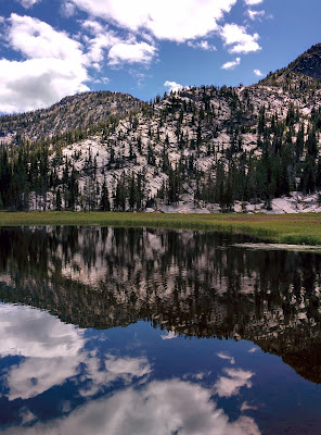
| Hoffer Lake reflections |
 |
| Panorama of Hoffer Lake and surrounding peaks...wonderful reflections! |
No comments:
Post a Comment