 |
| Tucson to Camp Verde! |
BAKER CITY!
View all Homeward Bound Photos
Friday,
April 4
Tucson to Camp
Verde (216 miles)
Loop around Sedona
area (87 miles)
We are on our way northward today!! A quiet morning around the CHRPA resort as we
pack up, unhook, and pull out around 8:15.
I finally gave up and switched the time in the truck back an hour,
figuring we would be back in Pacific time in Nevada anyway. Our only soirée back to Mountain Time will be
our brief drive across southern Idaho on Monday!
 |
| Final shot of downtown Tucson with Catalina Mts. in distance |
Smooth sailing through the morning traffic
of Tucson, enjoying a few downtown views against the Catalina Mts. as we head
north toward Picacho Peak. I need a
bathroom stop at Picacho, which also results in the purchase of a few t-shirts
at the gift shop next to the restrooms.
Ooops!
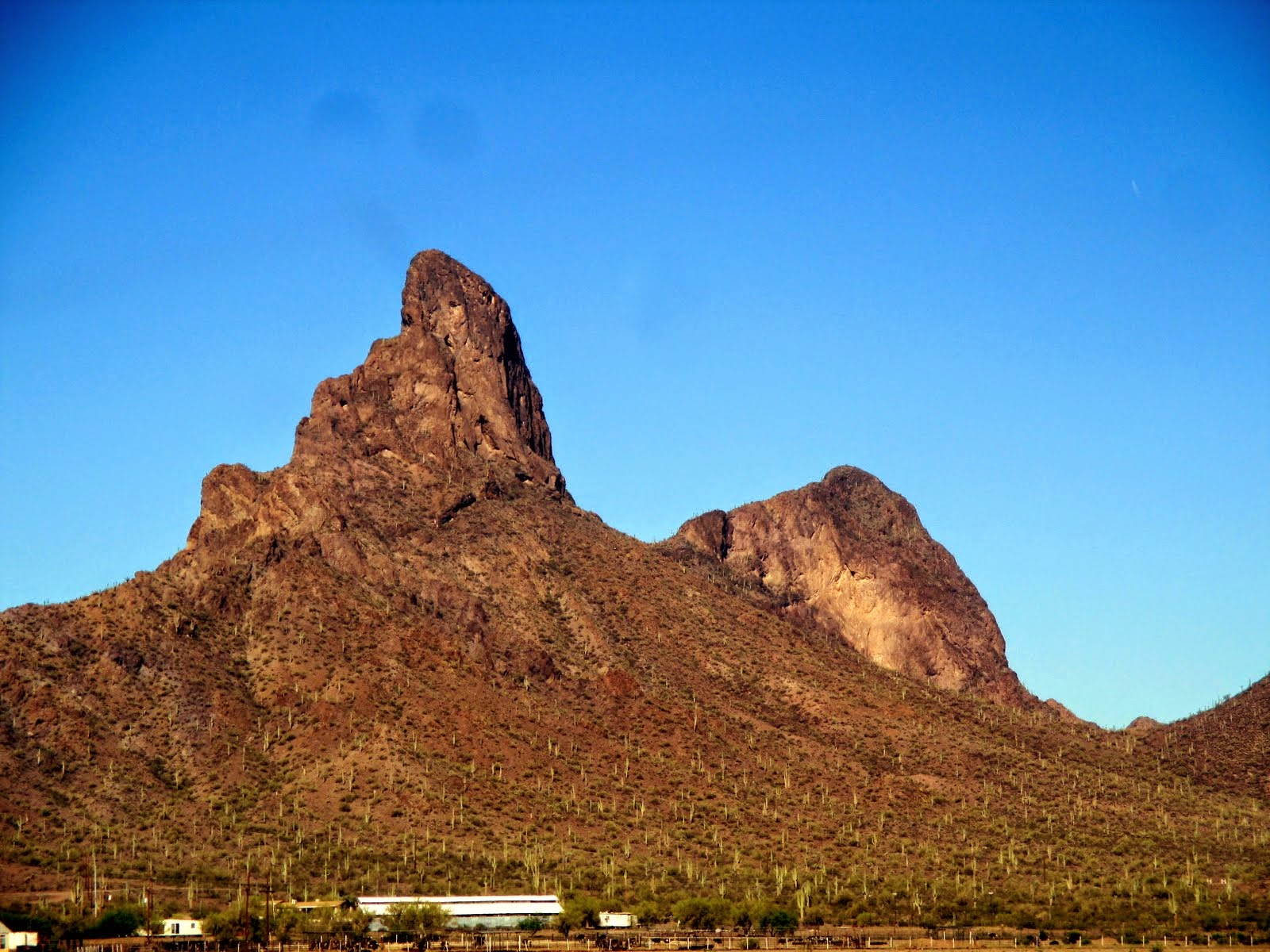 |
| Picacho Peak |
North of Phoenix the landscape changes dramatically. First a gradual reduction of saguaro cactus,
more rocky hills, and then we climbed – up a pass that wasn’t even marked on
the map! (Just west of Aqua Fria
National Monument which was only designated with the road to Bloody Basin.
Intriguing! ) At the top of the pass, we
opened out to a large plateau of ….grassland!!
NOT what we expected!!
A series of ups and downs, and we entered in and out of Prescott and Cocino National Forests. What trees comprise the forest, I’m not sure. All I saw were juniper and occasionally cottonwoods and mesquite!
 |
| ....to this? |
 |
| From this.... |
A series of ups and downs, and we entered in and out of Prescott and Cocino National Forests. What trees comprise the forest, I’m not sure. All I saw were juniper and occasionally cottonwoods and mesquite!
 |
| Dropping down into Verde Valley |
 |
| Our afternoon 'jaunt' |
 |
| The red rocks above the town of Sedona |
 |
| Bridge picture over Oak Creek |

 We then head south on Rte 179 toward
more rock formations and the interstate freeway. We stop to wander up a trail abit to where we
can get a good view back toward all the redrock. Pretty spectacular. By this point, my camera battery had died and
I was taking pictures with the phone!
Later, as I tried to take a few sunset pictures, I discovered I had
reached the max of pictures that the phone can carry! I hadn’t deleted anything all trip from the
phone, even though most of them had been transferred to the dropbox! Once I deleted a few, I was able to take a
picture of the sunset. (It didn’t turn
much in the way of color, anyway!)
We then head south on Rte 179 toward
more rock formations and the interstate freeway. We stop to wander up a trail abit to where we
can get a good view back toward all the redrock. Pretty spectacular. By this point, my camera battery had died and
I was taking pictures with the phone!
Later, as I tried to take a few sunset pictures, I discovered I had
reached the max of pictures that the phone can carry! I hadn’t deleted anything all trip from the
phone, even though most of them had been transferred to the dropbox! Once I deleted a few, I was able to take a
picture of the sunset. (It didn’t turn
much in the way of color, anyway!) |
| Pano from one of the sceniec vista points. |
 |
| Montezuma's Castle National Monument |
We tried to stop at the Casino for their
Happy Hour drinks and appetizers, but the smoke was pretty overwhelming, so we
left. Back to the trailer to scavenge
whatever we could find for some dinner.
I ate more of what I had for lunch: salad with a few tortillas chips and
some of my salsa for dressing!
Had
trouble with the internet this evening, so once again nothing is getting posted. Sorry people!
I would say maybe tomorrow, but I seriously doubt if we have a
connection at the luxurious Alamo RV Park!!
We are just hoping for some gas stations! Discovered it is further from Vegas to Ely
than we thought, and we will need a few more gallons to make it all the
way!
This
is a quiet park. So sirens, helicopters,
or army planes filling the night air with their sounds! Hope I can sleep!! G’night.  |
| Sunset from trailer on mountains beyond Verde Valley |
SATURDAY, APRIL 5
Camp Verde, AZ to Alamo, NV (392 miles)
I had to write this entry once before on an email since when we got to Alamo, the laptop had a 'corrupted user profile' and I couldn't even log on to the computer! I sent a MAYDAY! to Jed and then discovered I also didn't have T-Mobile coverage. Not a good ending to a good day of travel! And the Alamos RV Park was reputed to have good internet! I finally sent Jed an email on Rick's Kindle. Re-reading my Kindle email has been a challenge as Auto-correct really did a number on sections!
 |
| Ponderosa Pines!!! |
 |
| Humphreys Peak |
I had done my research the night before and had our gas stops outlined for the day. First one, Exit 185 just west of Flagstaff. Most of our stops will be at Flying J's or Pilots. From here until Kingman I take the wheel (145 miles!) Rick and I tried to remember the last time we had driven this stretch of highway. Finally figured on one trip back from Jed's and it was late in the evening and most of it was dark,. We spent that night in Kingman. The other time was in 1994 coming out of the Grand Canyon as we headed over toward Needles and the Mohave. So....this was one of the rare times in the daylight!! It is not a flat section of highway! Up and down the ridges as we saw peaks to the south and the canyon plateau to the north. It was a pretty section of road to drive. (Sorry, no picture....I was driving!)
 |
| Dropping down into the Colorado River canyon at Hoover Dam. |
 |
| One state closer to home! |
 |
| Glitz town of Las Vegas |
 |
| Roadside flowers... |
 |
| Nearing Alamo |
I called earlier today to make sure gas was available at Alamo, as we knew we couldn't get from Vegas to Ely on one tank. Yes! At $3.76 gallon, but we didn't care at price here! (Ended up we got free coffee with the fillup so that lowered the price!)
 |
| Our site at Alamo RV...and we did have internet! I just didn't have a computer! |
SUNDAY, APRIL 6
Alamo, NV to Jerome, ID (405 miles)
Up early to the sound of a rooster crowing and the cattle mooing for their morning hay! Ah, life in rural America!! It is 43 degrees in the trailer - glad I put the heater out to take a little of the chill off. We eat and dress quickly and are on our way by 7:30a headed north. Unfortunately, a NNW wind accompanies us much of the day, in varying strength. But at one point, Rick was sure we were going to make it to Ely on our tank of gas! And we only had 145 miles to go!! Between the long uphill haul and the headwind, we probably didn't average more than 7-8 miles per gallon this morning!
 |
| White River Narrows |
 |
| Another Nevada mountain range south of Ely. |
 |
| "Ghost Mt." north of Wells - really is China Mt. but it looked awesome in the clouds! |
A quick stop in Wells for gas and Rick takes over for the final push of the day. Into Jackpot and over the border into Idaho! Lot of snowy mountain peaks and ridges, clouds circling about. Then flat agriculture between the border and Twin Falls. Over the Perrinne Bridge at Twin Falls and the Snake River, gas at the Flying J,and by 4pm we are pulling in to the Jerome KOA. The owner pulls up our file from the computer and we are quickly registered. The wind is blowing at 25-30 mph straight from the west. There is NO consideration of driving at all toward home at this point. We were just glad that it changed to a westerly wind mid way through the day and wasn't a direct head wind ALL day!
I picked up a container of Chicken Pot Pie soup at the Flying J to augment our meager dinners - we are cleaning up the food in the trailer! NOT MUCH LEFT!! A Subway breakfast is looking good....either that or oatmeal!
About 5 hours into Baker City tomorrow!!!
MONDAY, April 7
Final Push into Baker City (248 miles)
Praise God! The winds died down to a 'gentle' 5-8 mph around 10pm last night. It is a beautiful BRISK morning (30's - Yes, I ran the heater last night!) But the sun is shining on the trailer as we pack up, so the fabric isn't as stiff as it was yesterday to fold in. Oh, we ate oatmeal for breakfast! This is an economy run, especially since gas is going to run over budget! (Thank you head winds!)
We are on our way around 7:45, a little later due to the time we took to thorough clean the tub and bathroom and kitchen sink - those places where water going down a drain is very helpful! We want to clean the rest of the trailer so it is ready for Montana when we get home.
This is my stretch of highway in Idaho, so I take the wheel first today. A slight headwind but nothing like yesterday! We wind our way towards Boise, the sun at our backs (thank you!), and snowy mountains of the Sawtooths peaking up from behind the front ridges all the way to our north. At the rest area just east of Boise we stop for a bathroom break and to switch drivers.
Rick steers us through lots of construction traffic in Boise and a stop in Caldwell for gas. Final Wal-Mart stop in Ontario (partially to stock up on trailer supplies needed for Montana) and a quick grab of lunch from the deli in the store. I take my HOME picture of the Elkhorns as we crest the ridge at Pleasant Valley - the mountains are accommodating today and clear in the distance.
Home at 1:15pm. Luke pulls up 5 minutes later and helps us unload! What a guy!
This was definitely a work trip only. A few weekend side-trips, and a one day delay coming home to visit Sedona. Otherwise, as Rick said at one point, "I haven't worked this consistently since I retired! I'm tired!" We put in a total of nearly 300 volunteer hours in 5 weeks. (OK, I realize that is only a 30 hour work week each, but hey, we ARE retired!)
A few trip totals.....just for the record. :)
Total Miles: 3505
Total Trailer Miles: 2882
Highest Gas Price: $3.76, Lowest: $3.19
Total Cost: $2788
Daily Average: $65
Volunteer Hours: 295
Final Push into Baker City (248 miles)
Praise God! The winds died down to a 'gentle' 5-8 mph around 10pm last night. It is a beautiful BRISK morning (30's - Yes, I ran the heater last night!) But the sun is shining on the trailer as we pack up, so the fabric isn't as stiff as it was yesterday to fold in. Oh, we ate oatmeal for breakfast! This is an economy run, especially since gas is going to run over budget! (Thank you head winds!)
We are on our way around 7:45, a little later due to the time we took to thorough clean the tub and bathroom and kitchen sink - those places where water going down a drain is very helpful! We want to clean the rest of the trailer so it is ready for Montana when we get home.
 |
| Getting closer! |
Rick steers us through lots of construction traffic in Boise and a stop in Caldwell for gas. Final Wal-Mart stop in Ontario (partially to stock up on trailer supplies needed for Montana) and a quick grab of lunch from the deli in the store. I take my HOME picture of the Elkhorns as we crest the ridge at Pleasant Valley - the mountains are accommodating today and clear in the distance.
 |
| Homecoming! Our welcome! |
Home at 1:15pm. Luke pulls up 5 minutes later and helps us unload! What a guy!
This was definitely a work trip only. A few weekend side-trips, and a one day delay coming home to visit Sedona. Otherwise, as Rick said at one point, "I haven't worked this consistently since I retired! I'm tired!" We put in a total of nearly 300 volunteer hours in 5 weeks. (OK, I realize that is only a 30 hour work week each, but hey, we ARE retired!)
A few trip totals.....just for the record. :)
Total Miles: 3505
Total Trailer Miles: 2882
Highest Gas Price: $3.76, Lowest: $3.19
Total Cost: $2788
Daily Average: $65
Volunteer Hours: 295
No comments:
Post a Comment