Ah….back to
Lincoln, the trailer, showers, dinner, and an evening of planning, writing, etc.
Click HERE for all of today's pictures.
 |
| Our route for today! |
Friday, October 4, 2013
Sabbaday
Falls Hike and Covered Bridges
Mt.
Washington Auto Toll Road
125
mile loop
What a
difference a little heater makes! We
turned it on last night as soon as we got home and it warmed the trailer
up. This morning it was 38 degrees in
Lincoln, 42 in the trailer. I turned it
up and within an hour we were a toasty 60 degrees and climbing still! It makes a difference when we can keep it
warmer in the evening.
 |
| Colors and mountains from viewpoint |
Anyway,
a lazy morning somewhat. I go up to get
our coffees at 7:15 and we read, etc. until 8 when we really start moving for a
9am departure for today’s adventures. I
had checked the weather and it was to be cloudy, even foggy, at the summit of
Washington until noonish and then improving for even a little sunshine by
2pm. So….we switch plans and decide to
take the long way over to the mountain and take our time getting there! That involves the Kancamagus Highway across
the southern part of the White Mountains.
I drive – time for Rick to have a break!
We stop at several viewpoints, noting that we are now in National Forest
and the bathrooms are closed, etc. due to the Federal shutdown. The colors are still spectacular on this
stretch. Climb up a notch and enter a new
watershed.
 |
| This hillside was way too pretty! |
We stop
at Sabbaday Falls trailhead (at least no recreation parking fee required with
the shutdown!) and walk the short .3 mile up to the falls. This is a series of falls which take a right
turn due to soft basalt and a fault in the rocks. The lower section is like a square
flume. Pretty, and the woods surrounding
are filled with trees and changing foliage.
I even spot a bright cluster of purple flowers!
 |
| Upper part of Sabbaday Falls |
Just
past Sabbaday Falls, we stop at the oldest remaining homestead in the White
Mts: the Russell-Colbath house. It was
built in the early 1800’s. The story
goes the last woman to live there said goodbye to her husband one night as he
said he was going ‘out’. She put the
light on for his return. He didn’t
come. For 39 years, she lit a light
every night to welcome him home. He
returned 42 years later, 3
 |
| Trail colors along Sabbaday trail |
years after she died at the age of 80. He had been wandering the world legend
says. What a jerk I say! I would have been neat to go inside the
house, but….government shut down!
Closed!
We turn north
on the Bear Notch Road, which will cut off a little distance as we drive up to
Mt. Washington. I also wanted to take
this route because it takes us past a covered bridge at Bartlett which houses
the Covered Bridge gift shop! Two in
one!! Did a little Christmas shopping and picked up a little covered bridge
ornament for the tree.
 |
| Covered Bridge Gift Shoppe! |
North on 16,
we stopped at another bridge to the town of Jackson. This covered bridge was very similar to the
one in Bath, only it is actively in use.
The pedestrian sidewalk is much appreciated as the cars came whipping
through the bridge. We tried to stop at
another waterfall, but ….government shut down – they had the road barricaded
for this one! L
Finally,
around 12:30, we arrive at the Mt. Washington Auto Road Toll Booth. We pay our $34 ($26 for car and driver and $8
for each passenger). We get a CD audio
tour, a bumper sticker, and lots of information about roads at high elevations,
no guard rails, fear of heights, etc.
Drivers are advised to use low gear the entire way both ascending and
descending from the summit. It is 7.6
miles up, rising from an elevation of about 1800’ to 6288’. The AVERAGE grade is 12%. The amazing thing about the road is that it
was completed in 1861!! The Civil War
was being fought! Cars hadn’t even been
thought of. And modern engineers, when
given the opportunity to reassess the route, couldn’t find any fault with the
route designed back in the 1850’s! Rick’s
comment for the day (and he said I could quote him!): “That was one bad-ass road!” It is narrow, bumpy in places, with some
sharp turns. There are pull offs which
are especially important in the summer for cooling off engines and brakes. It takes about 25 minute to drive up to the
top. I commented that neither of our
mothers nor Patty Bogart would have like riding on the outside edge of the
truck!
 |
| Lower section of Mt. WA road |
Needless to
say….Rick and I switched drivers at the toll booth! I had NO INTENTION of driving! Hondi
handled the pressure beautifully! It is
fascinating to watch the change in the environment as you climb. First we went through gloriously colored
hardwood forest, then a mixed forest of hardwood and conifers, then stunted
firs, and finally alpine tundra like terrain.
To one side four other peaks of the Presidential range rise up above a
sweeping chasm. Below in the valley, the
red-orange carpet of trees covers everything.
 |
| Cog railroad approaches the summit |
 |
| Rick's long arms so come in handy! |
 |
| The valley colors below. |
We park and
walk up the stairs to the 30 year old State Park visitor center. The top of the mountain is a NH state
park. Restrooms, cafeteria, gift shop,
you name it. Appalachian Trail hikers
come through regularly. This is the site
of the Mt. Wahsington weather observatory.
It is known for the ‘worst weather in the world’. Here the highest recorded wind speed was 231
mph in 1934. It averages hundreds of
inches of snow each winter and the park keeps a crew up there!! Since 60% of the time the summit is in the
clouds, I consider it a good day that we could see for miles! It was cold!
 |
| Tip Top House |
We visit the
Tip Top House, which was built in the late 1800’s as a guest house for the many
visitors who traveled up the road (usually by horseback or wagon in those
days!) A wonderful little museum. We liked the ‘bunk room’ which was a series
of 3 high bunks along a wall. Little
cubicles with a curtain in front. A
blanket and not much in the way of mattress!
A cog
railroad was built at some point to carry people and supplies to the
summit. The access for the railroad is
on the opposite side of the mountain.
While we were there 4 cars came up, depositing 30-40 people each. In peak season the railroad probably helps
relieve the congestion at the top.
 |
| Road heading down, drop ...... |
 |
| You have to love the contrast of the trees! |
We took
pictures, checked out a gift shop for a few postcards and a pin, and headed
back down the mountain around 2:30. The
sun had broken through about a half hour earlier. Guess the weatherman was right for a
change! The trip back down was just as
spectacular, and fortunately, uneventful!
 |
| Another colorful vista! |
 |
| Happy Hour at Woodstock Station! |
Rick
continued to drive and we headed back around a circle to Lincoln via the towns
of Gorham, Twin Mountain, and back through Franconia Notch. Decided to drive right past the campground
and pick up a little dinner in ‘town’.
It was 4 pm. We struck out on the
strip in Lincoln so went to the Woodstock Station Inn right in North Woodstock. It is an old railroad station that was cut in
half and moved to this location. A maze
of rooms and hallways, but we finally got directed to the outdoor bar and
inquired about happy hour! Yes! From 3-5 – appetizers half price! Rick tries the local brewed Pigs Ear Ale and
I have a glass of wine. We order ‘Nasty
Nachos’ and Sweet Potato Raviolis (with a cayenne kick!) – Another great
meal!!
Back to the
trailer to relax for the evening.
Tomorrow? A hike!!! G’night!
Click HERE for today's pictures
Saturday, October 5, 2013
Falling
Waters Trail Hike
Franconia
Notch SP
 Today could be our last decent day in the
mountains, so a hike is in order! After
a not so quiet morning (the campground is filled with some families and young
children, most of whom are NOT very quiet nor did they sleep in very long! We are right on the corner by the ducks and
the playground, so…..’nuf said!
Today could be our last decent day in the
mountains, so a hike is in order! After
a not so quiet morning (the campground is filled with some families and young
children, most of whom are NOT very quiet nor did they sleep in very long! We are right on the corner by the ducks and
the playground, so…..’nuf said!

We are
on our way up Franconia Notch again, this time to stop at a Trailhead Parking
area for the Falling Waters Trail. This
is one of the more popular hikes in the area and the parking lot shows it! Rick and I have to park in a bus parking spot
(when we return later, at least 10 other cars are so parked as well, not to
mention the half mile of cars parked along the side of the interstate!) We somewhat had the feeling at times that we
were hiking up Everest….a long line of people at times on the trail. All sorts of languages heard! Japanese, Indian, French, a Scandinavian,
etc. Amazing. LOTS of young people! College students in many cases. The trail continues up about 3000’ to Little
Haystack Mt. and the Franconia Ridge Trail (and two 5,000' peaks) – it is reportedly a fantastic
hike. Our goal was to hike the thousand
feet up to view a series of three waterfalls.
 |
Ginger climbs up some
rock 'steps' along the trail |
Having
hiked now in the White Mountains, my esteem for those who traversed this
portion of New Hampshire on the Appalachian Trail has risen highly! These are rugged peaks – the trails are
boulders in places, the routes steep.
ACT hikers often are quoted as saying the White Mts. are the most spectacular
of the through hike AND the most difficult with dramatic climbs and drops in
elevation.
 |
| Swiftwater Falls |
About a
scant half mile past the last waterfall, Rick and I stop to ascertain a plan. We realize there are no more
waterfalls, having asked several hikers as they passed by us on the trail. Now rested, I suggest we go a little further
(somewhat not wanting to let go of the hard-earned elevation I had just
gained!)
 |
Rick at the upper part
of Cloudland Falls |
Well…..we
soon got separated as I couldn’t keep up with Rick and more and more people
came between us. Rick eventually climbed
up to a side trail down to what is called Shining Rock – a huge granite slab
with views of the valley. He probably
logged about 2.5 miles one way and 2500’ in elevation. The summit of Haystack was about a half mile
away. I figure I went 2 miles one way and 2000'.
 |
| Colors in the trees |
Not
certain if Rick was ahead of me or behind me (I wondered if he had gone off
trail for a RR break) I continued hiking for about another half mile before
finally stopping. With the message to
several groups of hikers to let him know that I had turned back, I headed back
down the trail, passing a steady stream of people coming up the trail.
Long
story short….At the top waterfall, I left my tie dye bandana as a marker with
the word CAR spelled out in birch sticks. (I didn't think to take a picture!) We were reunited at the bottom of the trail! And Rick returned my bandana to me!
 |
| Cloudland Falls |
So….what
did we see along the way? Lower
elevations of hardwood trees – lots of yellows and golds, scattered patches of
red. Thick woods, mushrooms, and lots of
rocks in the trail! The waterfalls were
more cascades, although the Cloudland Falls is more of a horsetail fall –
narrow at the top and widening with feathery cascades to more than 25 feet at
the bottom. All the pools were filled
with swirling leaves.
 |
| Colors with birch trunk |
After
the falls, the trail wound through thick conifer forest, climbing steadily in a
series of switchbacks. The trees
prevented any views of the valley. Rick
did say it opened up a little up by the junction, but the trees were pretty
thick all the way to the top, reaching treeline shortly before the Haystack
summit.
We then
drove on up to see the Old Man of the Mountain Memorial near Cannon Mt. The citizens of New Hampshire have donated
funds to create this park on the shores of Profile Lake which sits at the base
of the cliff where the Old Man USED to be.
They have done an amazing job of creating a series of black posts, with
a carefully crafted (we are talking major engineering in art here!) to
 |
| These were pretty amazing! |
create
the image of the Old Man when you stand in the exact correct spot according to
your height. It worked!
From
there we drove down the highway to The Basin – a series of pools and mini
waterfalls on the Pemigewasset River. The
Basin itself is a deep pool created by eons of water, round granite walls, with
the water entering in a kind of spigot fashion.
Pretty cool.
 |
| Pemigewasset River above The Basin |
Back to
the trailer around 3pm to shower, relax, and eventually get dinner. Rick is able to pull up a college football
game on the TV!
The
next three days are forecast for 60% chance of rain….we will plan our days
accordingly. The only church in town
other than the Catholic church is the Loon Mt. non-denominational…..take the
gondola to the top of the summit for church.
If the weather was forecast for something better, we might bite on
that. You get a special ‘church rate’ of
half price on the gondola! We need to do
laundry. There are shops to check out
and the Christmas Cottage. Should be
enough to keep us occupied while we hope for a little weather break!
 |
| The Basin in Franconia Notch |
Click HERE for today's pictures
SUNDAY, October 6, 2013
A
Sabbath Day of Rest!
 |
| Entry sign for Country Bumpkins |
Well,
this won’t take long to blog today!
Families are up early, the campground is active, but I still roll over
in my toasty warm bed and read until 8am.
Once up with the heater running, I work on updating my devotional blog
entries, drawing a few scribbles as necessary, most of the morning. Rick takes a long walk along the river while
it is still overcast and dreary, but not WET!
 |
| Moose at entry gate - he is 12' tall! |
The
campground empties quickly around the 11am checkout time and shortly afterwards
I take a walk around the Country Bumpkin acreage. I realized I hadn’t even walked down to see
what kind of river frontage we were on (only tent sites down along the river with
no electricity). We are on a beautiful
junction of Harvard Brook and the Pemiwagasset River! I took a number of pictures, including some
of the campground décor itself. There
are a number of cottages, some very nice. Everything is decorated for
autumn. As I wandered around, one of the
workers (the man I talk to every morning when I go for coffee!) was giving a
toddler a ride on an old red tractor! I
love the big moose wooden sculpture as you enter with a little bear poking
through his legs. Eventually I set my
chair out along the river bank and drew another scribble.
 |
| Along the Pemigawasset River |
We did
our laundry here at the campground as the rain started to fall mid afternoon. Dinner
late afternoon in the trailer as we combined two types of Mexican soup into one
pot and ate chips with it! High
class! Other than the $4.50 for laundry,
today should have helped our budget!
 |
| Red maple leaf |
Around
5 we drive 3 miles toward town, park in the post office parking lot, and make
phone calls to both our moms and Luke (checking on mail and the Pirates!) It was cold and wet….Rick went to the shelter
of the post office awning to talk to Mom R while I sat in the car with Mom
Mac. He returned and turned on the car
and the heater! We both talked with Luke
to check on things at home, back to the trailer for a little TV, end of Pirates
game, and….a game of rummy! Rick
won.
The
little heater can bring the temp up in this trailer 20 degrees in a short
time. Glad we brought it along!!! We also learned this evening that you can’t
run both the microwave and the heater at the same time. The circuit breaker in the strip worked and
everything shut down but the computer!!!
Learned that lesson!
MONDAY, October 7, 2013
Littleton, NH “Main Street USA”
A lazy
morning, listening to the scattered rain showers fall! We finally shower (this campground wins the
award for water pressure AND hot water!) and get ready to face the day around
10:30!! In getting our morning coffee,
the office asked what our plans were for the day and I said shops around
Lincoln. He suggested we drive up to
Littleton, about 25 miles north of here, and check out their Main Street. They have won awards for the revitalization
of their historic district downtown (sound familiar?) Well, it was a good decision in many ways!
I drove
up to Littleton and encountered thick fog as soon as we left Lincoln. Much like driving into the clouds. The rain was more misty than waterdrops. Once we got through the notch, we suddenly
emerged into sunshine! Wow! When we got out of the truck in Littleton, it
was muggy warm!
 |
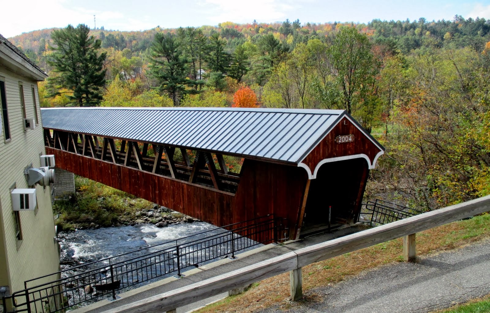
| Pedestrian covered bridge in Littleton |
We
enjoyed Main Street. I think Baker City
has done just as good a job in many ways, but there were a few special aspects
we really enjoyed. They built a covered
bridge to connect the two sides of town across the Ammonoosuc River – a 400’
long bridge!! It is for pedestrian
traffic only, and since it was built in 2004, definitely not very historic. But it spans a very scenic section of river
with multiple ripples and 1-2’ falls, so the viewing was good! There is an old grist mill down along the
riverfront which is still in use.
 |
| River and grist mill in Littleton |
 |
| Congregational Church |
Two
churches, Congregational and Methodist, anchor each end of Main Street with
their white steeples and crosses. The
Post Office/Courthouse was built in 1935 – a beautiful building. Before we leave town, we drove up to High
Street on the hill to see the Catholic church – it was built from rock – all of
it! Really cool.
Rick
got a haircut in Littleton!! Much
improved from the hippie look he was starting to sport, especially when he wore
his hat!
 |
| Rock Catholic Church |
What we
really enjoyed was called The Piano Project.
Scattered along the sidewalks of downtown are at least 4 pianos, covered
with a waterproof tarp, brightly painted, with lettering encouraging anyone to
sit down and play a tune. “All we ask is
you cover us up when you are done!” When
we first encountered a piano, someone was playing it….I was amazed at the paint
job, but not sure exactly what was going on.
Then we uncovered one other to take a peek, and saw two more. There was also a guitar all painted up and
sitting on a chair in a store front alcove.
It also said The Piano Project on it.
This reminded Rick and I of all the transformer boxes that were painted
in Mankato. Maybe Baker City needs to
find it’s niche for the downtown. A good
project for Crossroads to sponsor.
Hmmmmm….what could we paint that would be interactive, fun, and
represent Eastern Oregon??
 |
| The Piano Project....being played! |
Since
we didn’t take very long in Littleton, it wasn’t time to eat yet. So….a drive back down the highway to
Lincoln. We drove right back into the
storm…only worse now!! The fog was super
thick through the notch and the rainfall harder.
 |
| We drive right back into the storm as we near the Notch. |
We visited three stores in Lincoln, made one
small purchase, and by then it was 3pm.
Time for Happy Hour at the Woodstock Brewery!! We ordered another Nasty Nacho and this time
tried the Loon Dip as well. It was
pretty rich with Gorgonzola cheese, peppers, and spinach. I also opted for a Sangria today – served in
a 12 oz glass! Wow. We asked the bartender to change the station
to the Pirates game, which she did.
Unfortunately game didn’t end well.
We left in the 5th inning and made our last stop of the day:
The Christmas Shop. So many little
rooms, I kept getting lost! While we
were inside the storm really picked up again, howling wind and pounding rain. The lights all blinked out for a few seconds
at one point.
 |
| Boards in the morning light...most of the puddle is gone too. |
Now
settled into the trailer for the night. Rick had to put boards out to walk on from the truck to the trailer door. We have a rather large puddle in our campsite!! But now.....the rain seems to have finally stopped…momentarily. It is forecast to end sometime around
midnight, and then begin clearing! Hurray, for we hope to hike tomorrow up to Lonesome Lake.
Click HERE for today's pictures
TUESDAY, October 8, 2013
Lonesome
Lake Hike, Franconia State Park
4-5
miles UP!
 |
| Today's hike |
Sure
enough, around 11 pm last night the world was silenced – no more rain
drops! Glad we left the little heater
running as it cooled off! Today as we arise,
we can see patches of blue sky through the fast moving clouds.
As I
got coffee this morning, I talked with the owner about the nickelodeon piano in
the office/store area. Yesterday as we
picked up ice and asked to have the internet reset after the storm, Amy (office
gal) gave us a quarter to put into the piano so we could hear it play. Wow….what sound came out. Sometimes a little out of key, but…. The front is inset with stained glass, as is
a section cut out above the foot pedals at the bottom. I can’t even remember what song started
playing, but with the second verse it sounded like a whole orchestra. I realized the nickelodeon part is the 7
additional instruments: drum, cymbal, tambourine, organ, etc. Many are housed in the bottom section. Fun to watch.
Anyway, Amy’s dad is quite the antique buff and he collects this stuff
(the store is filled with things). Pretty
fascinating. He has been so gracious
all week as I daily go up to fill our coffee cups.
 |
| Trailhead sign and colors |
On the
road by 9:30ish and as soon as we enter the ‘notch’ the winds are back!!! And although there are still clouds on the
high peaks, mostly the skies are clearing!
We park at the trailhead. It is
still cool outside….2 t-shirts, vest, and windbreaker, plus gloves!
The
storm last night has done a number on the leaves. Whole hillsides are now barren – they look
light gray from a distance. Where has
all the color gone? Into the wind! Still a few golden trees right down in the
campground area, but those coming up for the ‘peak’ this weekend are going to
be disappointed!! The hike up to
Lonesome Lake is about 1.2 miles to the edge of the lake and another .3 to the
Appalachian Mountain Club hut.
 |
| Entry to AMC Hut at Lonesome Lake |
The AMC
maintains a series of 8 huts across the White Mts., each about a day’s hike
apart. The Lonesome Lake hut is open
year round, as are two others. In the
winter season, a caretaker is on duty for 7 days, and then has 7 days off. Two people share the job. This is still ‘summer season’, so the hut was
‘manned’ by three – 2 guys and a gal.
This is their JOB for 2 months: cook, host, lead a few nature classes,
emergency search and rescue, advise hikers.
We each bought one of the cookies available – a giant peanut butter
chocolate chip! Tasted good! The bunkhouses will sleep 48, and while they
were empty the night before, they often run at capacity in the summer months,
charging $98-118 each, which includes breakfast and dinner. It was interesting to talk with the gal.
 |
| Lonesome Lake at outlet |
 |
| Wooden plank walkway in bog |
The
lake sits somewhat in a low lying bog – so the trail is largely a series of
wooden planks around the lake. The
Appalachian Trail itself comes down off Kinsman Mt. to the hut, and then veers
off along Cascade Brook down to the notch floor. We hiked on it for about a 100 yards from one
trailhead to the hut!
 |
| At the lake |
 |
Lonesome Lake
from High Cannon Trail |
Upon leaving
the hut, we hike around the lake (.6 mile) and then take the Dutch Cutoff (.3)
up to High Cannon Trail. From this
junction, the HC Trail climbs….steeply…up the hillside to connect with the
Kinsman Ridge Trail. There was a
viewpoint marked on one of the maps that was our goal as we knew we didn’t have
the time or the supplies to tackle the whole loop. Neither of these last two trails are highly
maintained. We hiked about a half mile, climbing probably
another 500-600’, to where Rick found a rock slab overlooking Lonesome Lake and
the valley floor. In one place the trail
climbed up a ladder to ascend a sheer rock outcropping! Altogether from what I can figure, we went
about 4.6 miles and climbed between 1500 and 1600 feet.
 |
| Ginger ascends ladder section. |
I have
a definite new appreciation for the White Mts. trails again after today. The
mountains may not be high in elevations, but they are rugged. Trails are rarely flat or smooth! Grades are
steep! Especially our latter routes –
rocks, roots, and leaves. Always leaves
right now! And yesterday’s downpour
probably didn’t help the trail at all.
You could tell where rivers of water had poured down the trail, piling
up the leaves behind every rock.
 |
| I-93, Franconia Ridge mts., and our rock slab. |
Back to
the truck by 3pm, to campsite for showers, etc.
I drive over to Lincoln around 4:45 to do a little grocery shopping and
attend the Weight Watcher’s Meeting at 5:30.
(A good weigh-in….down 1.4 pounds!)
We leave in the morning, so we have to do a little thinking ahead as we
will be sleeping indoors for the next four nights! Good thing, because it is forecast for 30
degrees tonight. All layers on this
evening….little heater working hard to keep up in the 50’s!!
Click HERE for today's pictures.
THIS ENDS THE WHITE MOUNTAIN PORTION OF OUR BLOG.....TOMORROW WE ARE BOUND FOR KITTERY, MAINE. WE BEGIN OUR TREK SOUTHWARD!


 Today could be our last decent day in the
mountains, so a hike is in order! After
a not so quiet morning (the campground is filled with some families and young
children, most of whom are NOT very quiet nor did they sleep in very long! We are right on the corner by the ducks and
the playground, so…..’nuf said!
Today could be our last decent day in the
mountains, so a hike is in order! After
a not so quiet morning (the campground is filled with some families and young
children, most of whom are NOT very quiet nor did they sleep in very long! We are right on the corner by the ducks and
the playground, so…..’nuf said! 


No comments:
Post a Comment