
Friday, June 15
Click
HERE to view all pictures from our hike!
Today Rick and I had a clear schedule with clear skies! A great opportunity to take off....but where? We are in the awkward time of the year....too much snow still for the high country, but not quite enough still to snowshoe. We were going to pick up some new maps, but managed to drive around in circles trying to find the relocated Ranger District office, gave up and headed south out of town! Destination now? Sumpter, Bourne, and beyond!
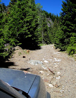 |
The Honda finds a way
through the rocks! |
Rick hiked up much of the road beyond Bourne last year, but this is the first time we have driven the truck up. The well graveled road from Sumpter deteriorates quickly upon entering Bourne, but we threaded our way around the rocks and boulders slowly. I mostly kept my eyes on the side of the road (spotting Forget-me-nots and Shooting Stars!) ..if I didn't watch the road, I didn't worry about whether the truck could handle it or not! Later Rick informed me that the Honda never even shifted from front wheel to four wheel drive! The route passes several old mines, completed with adits and rail tracks for the ore cars. The Cracker Creek canyon gradually narrows as the road climbs another thousand feet to where we parked.
 |
| Ritz Canyon |
Around 2.5 to 3 miles from Bourne, a jeep trail takes off from the left. We parked the Honda there and began our hike to the top of Cracker Creek Saddle. We immediately had to cross the creek, but a handy log spanned the water amid fields of marsh marigolds and buttercups. From there the trail was easy to follow....just follow the water flowing down the jeep road! Nothing like the path of least resistance in the early summer!
For about a half mile or so, the road was relatively clear of snow. Mini-waterfalls and mini-canyons marked the route, in places cutting so deep you could see the yellow-orange clay below. In one of those places, having just read up on the "Black Canyon of the Gunnison" in Colorado, I told Rick it was the "Orange Canyon of the Cracker". He replied, "That must make it Ritz Canyon!" So we called it!
 |
| A steep stretch of snow, but the saddle is in sight! |
The middle third of the hike was through a beautiful spruce forest, a rare sight in Eastern Oregon after the Spruce Budworm kill from 20 years ago. Dense shade made for snow drifts everywhere, with rivulets of water between them all. We got fooled a few times with soft drifts we plunged through, but for the most part the hiking was simple as the route gradually steepened! Finally we opened out to a very steep section of open snow, but with Cracker Creek Saddle visible in the distance!
 |
| Columbia Hill cornices of snow. |
The last section of "trail" crossed the jeep road frequently as we went straight up the open south slope to the saddle. We had to cross a cattle guard and barbed wire. The Elkhorn Crest trail was visible along the side of the mountain as it wound south from the saddle. Cracker Creek summit is the midpoint of the Crest Trail - north to Anthony Lakes 10 miles, south to Marble Creek Pass, 11 miles. From the saddle it is another 1+ mile to Summit Lake. Granted, our 2 mile hike climbed about 1100', but this is a much easier way to backpack into Summit Lake as opposed to the 10 mile trek in from Anthony!
 |
| Mt. Ruth at center right. |
We spent nearly an hour on top, enjoying the panorama view from Mt. Ruth to the north, to the deep cut of the North Fork of the Powder River and the Wallowa Mts in the distance to our east, to Red Mt. above the Summit Lake pocket, south down the Cracker Creek canyon, and Columbia Hill, with its fascinating snow cornices, just to our west.
 |
Memorial Site with Columbia
Hill in distance. |
I looked for flowers up on top, but sadly found just one tiny little clump of a clover like flower....with a bee! There were also some small clusters of lupine leaves emerging.
We found a 2007 grave marker at the top, with incredible views both north and south. Our guess is the deceased wanted his ashes taken to the summit of the Elkhorns. It was pretty neat.
 |
On Cracker Creek Saddle with Summit Lake
mountains behind us. |
Finally, after taking the mandatory picture of the two of us using the tripod, it was time to head down, a jaunt which went considerably quicker than the hike up! I got cocky and was jumping down through the snow and ended up on my face at one point when my left leg when all the way through! By the time we got back to the truck, both of us had wet feet!
This was Rick's Father's Day hike, so we stopped in Sumpter to celebrate with an early dinner at the Scoop and Steamer Restaurant. After a quick phone call, we then enjoyed a wonderful visit with Dean and Sharon Defrees at their ranch. A GREAT DAY in God's creation!!!
 |
Panorama view from top of Cracker Creek Summit
Left to Right: North to Mt. Ruth, east to North Powder River Valley, south toward Bourne, and west to Columbia Hill. |
 |
| Forget-Me-Nots |
BTW....if you look closely at the above panorama, find the "half" tree. Hug-in had trouble stitching together my picture because I moved two feet while taking the individual shots!
 |
| Shooting Stars |
I can't help including a few flower pictures! (There would be more, but they were out of focus!!)
 |
| Marsh Marigolds |
 Friday, June 15


No comments:
Post a Comment