NOTE: This post for the end of our Spring 2017 SW trip is very late due to poor internet while enroute and then a hectic and emotional May-June! (I was waiting to add the photographs!)
Click HERE to see all the Trip Home Photos OR HERE for the WHOLE trip!
Friday, 3.24.17
Click HERE to see all the Trip Home Photos OR HERE for the WHOLE trip!
Friday, 3.24.17
Tucson to Page, AZ
401 miles
What a beautiful day of
driving!!! Might even make me think
Arizona isn’t so ordinary a state after all!
 |
| Cactus! |
 |
| Yellow-orange patches dot the hillsides |
Traffic wasn’t too bad, but then again, I wasn’t driving!! Followed the signs to I-17 and just kept cruising. By 10:15 we were stopping in the tiny town of Anthem – a beautiful setting of green hillsides dotted with saguaros and patches of yellow. Gas, coffee, and then I take the wheel for the stretch north toward Flagstaff.
 We climb out of the Phoenix basin
steadily toward Flagstaff, more gorgeous hillsides of yellow, orange desert
mallow, and saguaros. At the top of a
long pull, we crest to a broad mesa of brown grasslands and far reaching
vistas! Occasionally we catch of glimpse
of Mt. Humphries’ 12,000’ in the far
distance near Flagstaff. Long drop into
Camp Verde where we stayed several years ago for a quick explore of
Sedona. We still plan to return to hike
more of the Sedona area, but not this trip!
At the top of the hill above Sedona, we pull over for a rest stop and a
second chance for me to make contact with the Panguitch CG we hope to stay at
in Utah. At that point, Rick takes the
wheel again. Good move on my part! We instantly pass a sign saying ‘Entering
Winter Driving Conditions’!! And we did
find snow between Sedona and Flagstaff – a steady 5-6” along the roadside. But the highway was totally clear! It was beautiful with the pine trees,
elevation 6,000 feet for much of the way.
We climb out of the Phoenix basin
steadily toward Flagstaff, more gorgeous hillsides of yellow, orange desert
mallow, and saguaros. At the top of a
long pull, we crest to a broad mesa of brown grasslands and far reaching
vistas! Occasionally we catch of glimpse
of Mt. Humphries’ 12,000’ in the far
distance near Flagstaff. Long drop into
Camp Verde where we stayed several years ago for a quick explore of
Sedona. We still plan to return to hike
more of the Sedona area, but not this trip!
At the top of the hill above Sedona, we pull over for a rest stop and a
second chance for me to make contact with the Panguitch CG we hope to stay at
in Utah. At that point, Rick takes the
wheel again. Good move on my part! We instantly pass a sign saying ‘Entering
Winter Driving Conditions’!! And we did
find snow between Sedona and Flagstaff – a steady 5-6” along the roadside. But the highway was totally clear! It was beautiful with the pine trees,
elevation 6,000 feet for much of the way.
 |
| Just north of Flagstaff |
 Then on to Page, 125 miles to the
north! First part of road is rimmed by
mountains with snowy tops, pines, and Joshua trees. Past Waputki Ruins NM and we enter a broad
grassland plateau with the Painted Desert in the distance to the NE. From Cameron and the junction to Grand Canyon
South Rim, the road is bordered by towering red cliffs to the east. We are on Navajo Nation lands at this
point. We traveled this road several years
ago in leaving the South Rim bound for the North Rim of the Grand Canyon (Hwy
89A). This time we plan to stay on Hwy
89 toward Page and circle the north side of the Vermillion Cliffs NM.
Then on to Page, 125 miles to the
north! First part of road is rimmed by
mountains with snowy tops, pines, and Joshua trees. Past Waputki Ruins NM and we enter a broad
grassland plateau with the Painted Desert in the distance to the NE. From Cameron and the junction to Grand Canyon
South Rim, the road is bordered by towering red cliffs to the east. We are on Navajo Nation lands at this
point. We traveled this road several years
ago in leaving the South Rim bound for the North Rim of the Grand Canyon (Hwy
89A). This time we plan to stay on Hwy
89 toward Page and circle the north side of the Vermillion Cliffs NM.  What a surprise we found at the
junction between the two! 89A turns west
and follows at river level below the cliffs.
The main hwy 89 veers sharply UP and OVER those red cliffs we have been
following and thru a narrow gap cut in the rock. Amazing views to the west, but not in a
position to get good pictures there. (No
room in the one scenic pulloff for a truck and trailer!) Once through the ‘slot’ we stayed on a high
plateau and a gentle downhill run all the way to Page!
What a surprise we found at the
junction between the two! 89A turns west
and follows at river level below the cliffs.
The main hwy 89 veers sharply UP and OVER those red cliffs we have been
following and thru a narrow gap cut in the rock. Amazing views to the west, but not in a
position to get good pictures there. (No
room in the one scenic pulloff for a truck and trailer!) Once through the ‘slot’ we stayed on a high
plateau and a gentle downhill run all the way to Page!  Page is NOT the flat desert area we
both envisioned next to the dam.
Sandstone cliffs, hills, and the convoluted fjords and bays at the end
of Lake Powel define the area. We find
our campground, get settled, and then at 4:30pm take off to explore a few
scenic vistas (and walk around a little).
We view the dam from the west at one point, then drive along the south
shore to a point above the lake, then over the dam bridge to the views from the
visitor center on the north side. VC was
closed, so we will check it out tomorrow. We have to check out of the campground by 11,
so our plan is to take a few short hikes in the morning, check out, grab a
brunch at Denneys, hit the VC, and then head north toward Panguitch, about 140
miles north of here.
Page is NOT the flat desert area we
both envisioned next to the dam.
Sandstone cliffs, hills, and the convoluted fjords and bays at the end
of Lake Powel define the area. We find
our campground, get settled, and then at 4:30pm take off to explore a few
scenic vistas (and walk around a little).
We view the dam from the west at one point, then drive along the south
shore to a point above the lake, then over the dam bridge to the views from the
visitor center on the north side. VC was
closed, so we will check it out tomorrow. We have to check out of the campground by 11,
so our plan is to take a few short hikes in the morning, check out, grab a
brunch at Denneys, hit the VC, and then head north toward Panguitch, about 140
miles north of here.
Quick restocking run to the Walmart
and then back to the trailer by 6:15p to relax!! Rick is tired, as he did MOST of the driving
today (I only logged about 85 miles L)
 |
| First two days route |
Page, AZ to
Panguitch, UT
144 miles
Well, we definitely left the warm
nights of Tucson!! Had to get the heavy
sleeping bag back out last night, and will definitely need everything we’ve got
when we get to Panguitch tonight! A
little disturbing sleep last night as we were close to the tent area and a
group was out talking until after midnight.
I can’t fault them, but a little quieter laughter would have been
nice!
 |
| Ging at Horseshoe Bend |
 |

Back to the truck to find the young
couple we encountered when we parked STILL trying to get into their
vehicle. They had locked the keys inside,
along with purse and phone. Very
friendly and personable Native American young adults, the gal was pregnant and
sitting on top of the truck trying to work a wire inside to push on the unlock
button. NOT a simple task. He asked if we had anything else that might
help and Rick looked all through our truck to no avail. I asked if her phone was inside as well. Affirmative.
Do you want to borrow mine to make a call? After struggling a bit more, she accepted the
offer. It was her father’s car and she
knew he was going to be furious, so reluctant to call! In the end, we were only able to make
suggestions and offer little real help. L
 |
| Springtime tree at Visitor Center |
Down to Denneys for brunch. I was hungry!
We ordered by had to patiently wait nearly 40 minutes for our meal to
arrive. Not the fastest Denneys!! But the food tasted good!! Then to the Visitor Center to learn more
about the dam (it was closed by the time we arrived yesterday). A well situated center set on the cliff
between the bridge and the dam – wonderful views down to the river and to the
face of the dam. Answered many of our
questions!
Finally, at 1:30pm we are ready to
head north to Panguitch!! The drive is
beautiful through red rocks, white rocks, juniper forests, and grassy
plateaus. Rick didn’t appreciate the
strong west headwind we had for much of the way, but we lost a lot of traffic after
the dam. A stop in Kanab (Abra-Kanabra!)
for gas and drinks, and then north past the roads to Zion and Cedar Breaks,
past the little campground we stayed at 4 years ago in

Glendale, and up to Panguitch. Arrived around 5:10 (having switched our clocks to Mountain Time when we passed the Utah border). A warm welcome from the host and we got into our site. Hitching Post was one of only a few choices – most everything else is still closed.

 |
| Between Glendale and Panguitch |
Glendale, and up to Panguitch. Arrived around 5:10 (having switched our clocks to Mountain Time when we passed the Utah border). A warm welcome from the host and we got into our site. Hitching Post was one of only a few choices – most everything else is still closed.
Sunday,
3.26.17
Kodachrome Basin
State Park
 |
| Contrails |
 I think this area of Utah is at the
crossroads of all the major airplane routes.
All morning long the only ‘clouds’ I see in the sky are the contrails of
crisscrossing planes, diffused in the upper level winds. You can’t look up at any time without seeing
at least one or two planes. Later in the
day it overcasts with ‘real’ clouds!
I think this area of Utah is at the
crossroads of all the major airplane routes.
All morning long the only ‘clouds’ I see in the sky are the contrails of
crisscrossing planes, diffused in the upper level winds. You can’t look up at any time without seeing
at least one or two planes. Later in the
day it overcasts with ‘real’ clouds! 
 I mentioned to Rick that Kodachrome
Basin looked pretty neat and was something NEW!
So we drive past the entrance to Bryce and another 13 miles to
Cannonville, and then 10 miles down a PAVED side road (a rarity in this part of
Utah once you get off the major highway) to the state park. Named for the wild variety of colors and the
newly invented Kodak color film in the 1950’s, it is a well maintained and
marked state park. A nominal $8 fee per
car to enter. I knew of one 3 mi trail,
but we found several others that we ended up taking first (a good choice to
make, as they were more spectacular than the one in the brochure!). We drove out to Shakespeare Arch, hiking only
the mile RT to the arch. A small feature
nestled at the top of a rock wall, but pretty.
Then back to the main part of the park and the 1.5 mi loop (my pedometer
says a little further!) on the Angel’s Palace trail. This took us up a broad slot to the top of a
layer of rock and a convoluting pattern of figure 8’s out to the end of fins
(on the top of them!), around what Rick described as piles of solid dinaosaur
poop (dark chocolate colored rock!), spires, and such. Always the solid sheer face of the white
gypsum layer beyond with its pinnacles and red stripes.
I mentioned to Rick that Kodachrome
Basin looked pretty neat and was something NEW!
So we drive past the entrance to Bryce and another 13 miles to
Cannonville, and then 10 miles down a PAVED side road (a rarity in this part of
Utah once you get off the major highway) to the state park. Named for the wild variety of colors and the
newly invented Kodak color film in the 1950’s, it is a well maintained and
marked state park. A nominal $8 fee per
car to enter. I knew of one 3 mi trail,
but we found several others that we ended up taking first (a good choice to
make, as they were more spectacular than the one in the brochure!). We drove out to Shakespeare Arch, hiking only
the mile RT to the arch. A small feature
nestled at the top of a rock wall, but pretty.
Then back to the main part of the park and the 1.5 mi loop (my pedometer
says a little further!) on the Angel’s Palace trail. This took us up a broad slot to the top of a
layer of rock and a convoluting pattern of figure 8’s out to the end of fins
(on the top of them!), around what Rick described as piles of solid dinaosaur
poop (dark chocolate colored rock!), spires, and such. Always the solid sheer face of the white
gypsum layer beyond with its pinnacles and red stripes.  Kodachrome Basin is known for its 60
plus spires of debatable origin. Many
are of a different layer of rock than the surrounding features; eg. A gray
pillar set in the midst of redrock.
Geologists are still working that one out.
Kodachrome Basin is known for its 60
plus spires of debatable origin. Many
are of a different layer of rock than the surrounding features; eg. A gray
pillar set in the midst of redrock.
Geologists are still working that one out.  A bite of lunch and then the Panorama
trail – at least the 3 mile loop of this potentially 6 mile trail! A variety of spires – one looked like a
volcanic plug the sides were so smooth (Ballerina Spire) and another nearby
looked like a gnome. We passed the Hat
Shop, but some of the hats had fallen off their pillars. Secret Pass was a short side loop well worth
the mini slot canyon and the beehive shaped pillars. I logged 15,000 plus steps today so we hiked
a few miles!!
A bite of lunch and then the Panorama
trail – at least the 3 mile loop of this potentially 6 mile trail! A variety of spires – one looked like a
volcanic plug the sides were so smooth (Ballerina Spire) and another nearby
looked like a gnome. We passed the Hat
Shop, but some of the hats had fallen off their pillars. Secret Pass was a short side loop well worth
the mini slot canyon and the beehive shaped pillars. I logged 15,000 plus steps today so we hiked
a few miles!!
Quick stop at Visitor Center for water
and a look at the gift shop (I picked up a post card with a cute Kodachrome
Film ‘joke’ on it.


Westward again toward a quick stop at
the Bryce Visitor Center to pick up trail information for tomorrow. By the time we waited in the line to enter
the park, we watched the flag lowered (it was 4:30pm) and just as we got to the
booth, the man shut the window and pulled the blinds. We drove on through, but found the VC had
also closed, so….not brochures! A wasted
side trip!
Back to the trailer in Panguitch for a
restful evening. Rick hooked up the
water earlier before we left so we could take a hot shower in the trailer. (The park has probably the weakest water
pressure we’ve found anywhere around for showers!) A call to Liz and Mom, and photo work (I only
took 175 today!) and bedtime!!

 |
Monday,
3.27.17
Bryce Canyon
National Park
Navajo-Peek-a-Boo
Loop Trails 4.9 miles
Mossy Cave – Tropic
Canal Waterfall .8 mile
 We awaken this morning and find pellet
snow falling to the ground! Not hail,
not flakes, but little tiny balls of snow that ‘clink’ when they hit the top of
the trailer! Forecasts are hard to read
as most of them say rainy later in the day, but the clouds are upon us
now!
We awaken this morning and find pellet
snow falling to the ground! Not hail,
not flakes, but little tiny balls of snow that ‘clink’ when they hit the top of
the trailer! Forecasts are hard to read
as most of them say rainy later in the day, but the clouds are upon us
now!  But we decide to head into Bryce and
do what we can do! We rather hoped the
weather would keep the crowds away, but it IS spring break and people are out
in droves!! Bundled up, but here!
But we decide to head into Bryce and
do what we can do! We rather hoped the
weather would keep the crowds away, but it IS spring break and people are out
in droves!! Bundled up, but here!
A quick stop at the VC to check on
trails, and we decide to take the Navajo-PeekaBoo Loop, a moderately strenuous
(I didn’t quite catch that part at the time!) 5 mile journey. I thought
we had done this trail before, but I sure didn’t remember most of it if we
have! (Fact check. Just reviewed old blogpost from 2012. We did NOT do the Peekaboo Trail that day,
but the Queen’s Garden-Navajo Loop. New
trail!)
 |
 The Peekaboo portion of the trail is a
constant delight of ever changing vistas, little passes. You are changing elevation all the time – up and
through a notch or tunnel, then down again into another mini amphitheater. The skies were overcast, then big patches of
blue with billowy white clouds. It was
like the sun was playing PeekaBoo as well!!
I once again took way too many pictures!! We were forever amazed by the changing colors
of the strata. The top layer with its
big cave-like pock marks. Then the dark
red layer of hoodoos. Then a white
layer, then pink. I took one picture
(but I think I deleted it) of yellow surfur and purple rhiolite colors on the
path – Baker Bulldog colors!!
The Peekaboo portion of the trail is a
constant delight of ever changing vistas, little passes. You are changing elevation all the time – up and
through a notch or tunnel, then down again into another mini amphitheater. The skies were overcast, then big patches of
blue with billowy white clouds. It was
like the sun was playing PeekaBoo as well!!
I once again took way too many pictures!! We were forever amazed by the changing colors
of the strata. The top layer with its
big cave-like pock marks. Then the dark
red layer of hoodoos. Then a white
layer, then pink. I took one picture
(but I think I deleted it) of yellow surfur and purple rhiolite colors on the
path – Baker Bulldog colors!!  The amphitheater is filled with
pockets of snow, especially on the north slopes. Makes for amazing pictures and color
contrasts. Also makes for a wet and
muddy and icy trail in places. Glad we
took our hiking poles with us today!
The amphitheater is filled with
pockets of snow, especially on the north slopes. Makes for amazing pictures and color
contrasts. Also makes for a wet and
muddy and icy trail in places. Glad we
took our hiking poles with us today!
The Wall Street portion of the Navajo
Loop is closed during the winter (just too steep, narrow, and hard to keep
clear from the snow), so we retrace our steps back up the multiple switchbacks
700’ to the rim. I put myself in creeper
gear (once again!) and made it the whole .6 mile without stopping. Was dead at the top!!


 Quick lunch from the tailgate of the
truck and then down 3 miles east to the Mossy Cave/Waterfall Trail. A short one, but a lack of water in the Tropic
Canal means the waterfall was pretty anemic, and the cave had lost all of its
ice except for one ice pinnacle deep on a shady corner.
Quick lunch from the tailgate of the
truck and then down 3 miles east to the Mossy Cave/Waterfall Trail. A short one, but a lack of water in the Tropic
Canal means the waterfall was pretty anemic, and the cave had lost all of its
ice except for one ice pinnacle deep on a shady corner.
Back to the trailer to cuddle up and
get warm and watch the storms descend.
We actually had a few drops of rain at the Mossy Cave Trail, but mostly
wind the rest of the evening. A cold
bitter wind. Will probably fight it all
the way across Utah tomorrow!
 |
| Route home! |
Panguitch, UT to
Wells, NV
357 miles
Once again, there is a dusting of
snow pellets on the ground. Rick had
shut all water down last night so all we had to do this morning was close up
the bed and unplug! Not a fast start,
but we are on our way by 8am. Check with
a trucker at the coffee stop leaving town to find that Bear Valley (Route 20)
across to I-15 is passable, although some snow on the road and slick in
places. ‘Just take it slow’ he
says!
 The snow, however, makes the journey
beautiful! (Of course, I wasn’t driving!) What started as a slightly scratchy throat
last Friday has evolved into a good case of congestion by this morning. Enough so, that I actually take some Daytime
cold medicine in Beaver.
The snow, however, makes the journey
beautiful! (Of course, I wasn’t driving!) What started as a slightly scratchy throat
last Friday has evolved into a good case of congestion by this morning. Enough so, that I actually take some Daytime
cold medicine in Beaver. 
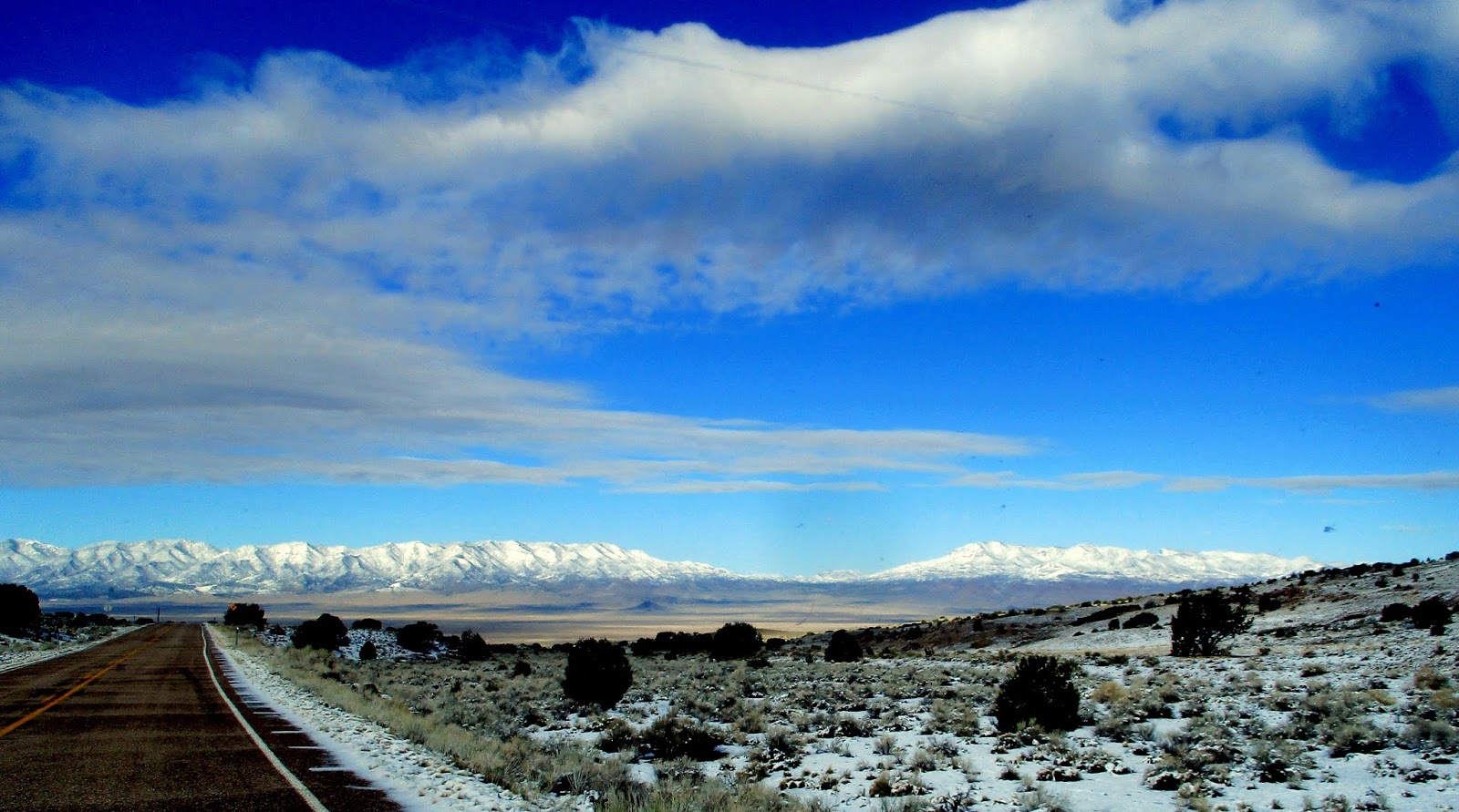
Our drive through the barren reaches
of Southeast Utah on Hwy 21 is gorgeous – the wind not quite as bad as we
feared, although still a definite factor! (We gassed up a lot to make sure we
could get across the big stretch!) Up
and down, over and through snowy mountain passes (not on the road, however…) It
has been 15 years since we traveled this route and we had forgotten how lonely
and beautiful it is. Traffic was
nonexistent other than an occasional truck.
Remote ranches, wild horses, and sheepherder’s wagons…
Past Great Basin National Park and Mt.
Wheeler’s 13,000’ summit, over Conner Pass at 7700’ (the highest on our return
trip), and into Ely, NV by 12:30. A stop
at the Subway for lunch and gas, and then I drive for about 90 miles toward
Wells. I pulled over 40 miles out of town
to let Rick take back over. I was
struggling abit.

We both decided we were tired, so
found Crossroads RV Park in Wells and stopped!
We’ll have 370 miles to go tomorrow, but will also gain an hour!
Read a little on the bed with the
afternoon sun hitting the tent, then showers (the best I have had since Randy’s!!),
and a quiet evening.

Wednesday,
3.29.17
Wells, NV to Baker
City
369 miles
Home!
No pretty snowy mountains welcoming us today, however, as the valley is
socked in with clouds and rain! Bummer!
A little delayed getting out of Wells
as we had trouble draining the sewer system – the hookup didn’t drain. But we figured it out! Rick drove up to Buhl, gassed up, and I
bought some cold medicine! Really
stuffed up. After hitting the freeway, I
drove for about 70 miles, giving Rick a break, - until the rest area just east
of Boise. Rick took us the rest of the
way in. We are both tired.
Didn’t hit the expected high winds
(thank you, God!) and no rain really until we got into Oregon! Better than expected.
Pulled into the driveway to find Patty
walking down street bearing a package with dinner for us and goodies for
Mom! She is amazing….and Wally is in the
Boise hospital dying!
TRIP TOTALS: Facts ‘n’
Figures
Miles
Total:3995 Trailer Only Miles:3107
Nights
Slept in Trailer: 32
Volunteer
Days: 11
Total Expenses:$2105
Housing:$294 Gas: $676
Food:
$751 Misc: $384
No comments:
Post a Comment